Colfax County, Nebraska

Last updated

Colfax County
Colfax County Courthouse (Nebraska) from NE 1.JPG
Colfax County Courthouse in Schuyler
Map of Nebraska highlighting Colfax County.svg
Location within the U.S. state of Nebraska
Nebraska in United States.svg
Nebraska's location within the U.S.
Coordinates: 41°35′N97°05′W / 41.58°N 97.09°W / 41.58; -97.09
CountryFlag of the United States.svg United States
StateFlag of Nebraska.svg  Nebraska
Founded1869
Named for Schuyler Colfax
Seat Schuyler
Largest citySchuyler
Area
  Total417 sq mi (1,080 km2)
  Land412 sq mi (1,070 km2)
  Water4.9 sq mi (13 km2)  1.2%
Population
 (2020)
  Total10,582
  Density25/sq mi (9.8/km2)
Time zone UTC−6 (Central)
  Summer (DST) UTC−5 (CDT)
Congressional district 1st
Website www.colfaxne.com
Colfax County, Nebraska Colfax County.png
Colfax County, Nebraska

Colfax County is a county in the U.S. state of Nebraska. As of the 2020 United States Census, the population was 10,582. [1] Its county seat is Schuyler. [2] The county and its seat are named after US Vice President (1869-1873) Schuyler Colfax. [3]

Contents

In the Nebraska license plate system, Colfax County is represented by the prefix 43 (it had the 43rd largest number of vehicles registered in the county when the license plate system was established in 1922).

History

Colfax County was established by the Nebraska legislature in 1869, as part of the division of Platte County into three parts. The new county was named for Schuyler Colfax, then the vice-president of the United States. The site of Shell Creek Station on the Union Pacific Railroad was chosen as the county seat, and renamed Schuyler also after Colfax. [4] Schuyler was incorporated in 1870, and the county's first courthouse was constructed in 1872. [5] [6]

Colfax County in May 2020 had the sixth-highest per capita COVID-19 infection rate of any American county. About one of every 23 residents has tested positive, with 467 cases. [7] As of October 2020, one in every 13 residents has tested positive, with 798 cases. [8]

Geography

According to the US Census Bureau, the county has an area of 417 square miles (1,080 km2), of which 412 square miles (1,070 km2) is land and 4.9 square miles (13 km2) (1.2%) is water. [9]

Major highways

Transit

Adjacent counties

Demographics

Historical population
CensusPop.Note
1870 1,424
1880 6,588362.6%
1890 10,45358.7%
1900 11,2117.3%
1910 11,6103.6%
1920 11,6240.1%
1930 11,434−1.6%
1940 10,627−7.1%
1950 10,010−5.8%
1960 9,595−4.1%
1970 9,498−1.0%
1980 9,8904.1%
1990 9,139−7.6%
2000 10,44114.2%
2010 10,5150.7%
2020 10,5820.6%
US Decennial Census [10]
1790-1960 [11] 1900-1990 [12]
1990-2000 [13] 2010 [14]

2020 census

Colfax County, Nebraska – Racial and Ethnic Composition
(NH = Non-Hispanic)
Note: the US Census treats Hispanic/Latino as an ethnic category. This table excludes Latinos from the racial categories and assigns them to a separate category. Hispanics/Latinos may be of any race.
Race / EthnicityPop 2000 [15] Pop 2010 [16] Pop 2020 [17] % 2000% 2010% 2020
White alone (NH)7,6176,0315,018
Black or African American alone (NH)549375
Native American or Alaska Native alone (NH)173326
Asian alone (NH)142450
Pacific Islander alone (NH)342
Some Other Race alone (NH)111716
Mixed Race/Multi-Racial (NH)4242102
Hispanic or Latino (any race)2,7324,3154,993
Total10,44110,51510,582100.00%100.00%100.00%

As of the 2000 United States census, [18] there were 10,441 people, 3,682 households, and 2,592 families in the county. The population density was 25 people per square mile (9.7 people/km2). There were 4,088 housing units at an average density of 10 units per square mile (3.9/km2). The racial makeup of the county was 81.73% White, 0.07% Black or African American, 0.19% Native American, 0.20% Asian, 0.14% Pacific Islander, 15.94% from other races, and 1.73% from two or more races. 26.17% of the population were Hispanic or Latino of any race. 28.8% were of German and 24.2% Czech ancestry.

The 2020 United States census said that the county was 47.4% non-Hispanic white, 3.5% black African-American, .5% Asian and 47.2% Hispanic.

There were 3,682 households, out of which 35.60% had children under the age of 18 living with them, 58.90% were married couples living together, 7.10% had a female householder with no husband present, and 29.60% were non-families. 25.70% of all households were made up of individuals, and 15.40% had someone living alone who was 65 years of age or older. The average household size was 2.80 and the average family size was 3.31.

The county population contained 28.90% under the age of 18, 8.50% from 18 to 24, 27.90% from 25 to 44, 18.70% from 45 to 64, and 16.00% who were 65 years of age or older. The median age was 35 years. For every 100 females there were 106.40 males. For every 100 females age 18 and over, there were 105.70 males.

The median income for a household in the county was $35,849, and the median income for a family was $40,936. Males had a median income of $25,656 versus $20,485 for females. The per capita income for the county was $15,148. About 7.20% of families and 10.80% of the population were below the poverty line, including 13.80% of those under age 18 and 7.90% of those age 65 or over.

Communities

Cities

Villages

Politics

Colfax County voters are reliably Republican. In only one national election since 1936 did the county select the Democratic Party candidate.

United States presidential election results for Colfax County, Nebraska [19]
Year Republican Democratic Third party
No.%No.%No.%
2020 2,63670.75%1,02527.51%651.74%
2016 2,17167.55%85926.73%1845.72%
2012 2,05166.83%96931.57%491.60%
2008 2,01863.00%1,12535.12%601.87%
2004 2,58971.26%99027.25%541.49%
2000 2,33870.53%86326.03%1143.44%
1996 1,95455.23%1,06530.10%51914.67%
1992 1,91546.21%1,01124.40%1,21829.39%
1988 2,32959.75%1,54239.56%270.69%
1984 2,99974.68%98124.43%360.90%
1980 3,25973.17%89320.05%3026.78%
1976 2,36457.34%1,66640.41%932.26%
1972 2,79971.66%1,10728.34%00.00%
1968 2,26464.48%93226.55%3158.97%
1964 1,97247.19%2,20752.81%00.00%
1960 2,50455.91%1,97544.09%00.00%
1956 2,84365.07%1,52634.93%00.00%
1952 3,33269.56%1,45830.44%00.00%
1948 1,92850.41%1,89749.59%00.00%
1944 2,31451.51%2,17848.49%00.00%
1940 2,58752.28%2,36147.72%00.00%
1936 1,64432.39%3,21063.25%2214.35%
1932 64813.56%4,07685.29%551.15%
1928 1,43234.14%2,74665.47%160.38%
1924 1,45039.02%1,29334.80%97326.18%
1920 1,99266.29%95731.85%561.86%
1916 89734.78%1,62863.13%542.09%
1912 62029.52%99847.52%48222.95%
1908 1,15946.68%1,26751.03%572.30%
1904 1,18053.03%76834.52%27712.45%
1900 1,03342.63%1,35756.00%331.36%

See also

Related Research Articles

<span class="mw-page-title-main">Colfax County, New Mexico</span> County in New Mexico, United States

Colfax County is a county in the U.S. state of New Mexico. As of the 2020 census, the population was 12,387. Its county seat is Raton. It is south from the Colorado state line. This county was named for Schuyler Colfax (1823–1885), seventeenth Vice President of the United States under U.S. President Ulysses S. Grant.

<span class="mw-page-title-main">Platte County, Nebraska</span> County in Nebraska, United States

Platte County is a county located in the U.S. state of Nebraska. As of the 2020 United States Census, the population was 34,296. Its county seat is Columbus. The county was created in 1855.

<span class="mw-page-title-main">Douglas County, Nebraska</span> County in Nebraska, United States

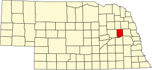
Douglas County is a county located in the U.S. state of Nebraska. As of the 2020 United States Census, the population is 584,526. It is the state's most populous county, home to well over one-fourth of Nebraska's residents. Its county seat is Omaha, the state's largest city. The county was established in 1854 and named after Stephen A. Douglas (1813–1861), who was then serving as Senator from Illinois.

<span class="mw-page-title-main">Dodge County, Nebraska</span> County in Nebraska, United States

Dodge County is a county in the U.S. state of Nebraska. As of the 2020 United States Census, the population was 37,167. Its county seat is Fremont. The county was formed in 1855 and named after Iowa Senator Augustus C. Dodge.

<span class="mw-page-title-main">Cuming County, Nebraska</span> County in Nebraska, United States

Cuming County is a county in the U.S. state of Nebraska. As of the 2020 United States Census, the population was 9,013. Its county seat is West Point.

<span class="mw-page-title-main">Burt County, Nebraska</span> County in Nebraska, United States

Burt County is a county in the U.S. state of Nebraska, bordering the west bank of the upper Missouri River. As of the 2020 United States Census, the population was 6,722. Its county seat is Tekamah. The county was formed in 1854 and named after Francis Burt, the first governor of Nebraska Territory.

<span class="mw-page-title-main">Buffalo County, Nebraska</span> County in Nebraska, United States

Buffalo County is a county located in the U.S. state of Nebraska in the Midwestern United States. As of the 2020 United States Census, the population was 50,084, making it Nebraska's fifth-most populous county. Its county seat is Kearney. The county was created in 1855 and was organized in 1870. It was named after the once-prevalent bison herds of the Great Plains.

<span class="mw-page-title-main">Schuyler County, Missouri</span> County in Missouri, United States

Schuyler County is a county located in the northeastern portion of the U.S. state of Missouri. As of the 2020 census, its population was 4,032, making it the fourth-least populous county in Missouri. Its county seat is Lancaster. The county was organized February 14, 1845, from Adair County, and named for General Philip Schuyler, delegate to the Continental Congress and U.S. Senator from New York.

<span class="mw-page-title-main">Page County, Iowa</span> County in Iowa, United States

Page County is a county located in the U.S. state of Iowa. As of the 2020 census, the population was 15,211. The county seat is Clarinda. The county is named in honor of Captain John Page of the 4th U.S. Infantry, who was mortally wounded in the Battle of Palo Alto.

<span class="mw-page-title-main">Jasper County, Iowa</span> County in Iowa, United States

Jasper County is a county in the U.S. state of Iowa. As of the 2020 census, the population was 37,813. The county seat is Newton. The county was organized in 1846 and is named after Sergeant William Jasper, a Revolutionary War hero.

<span class="mw-page-title-main">Colfax, Indiana</span> Town in Indiana, United States

Colfax is a town in Perry Township, Clinton County, Indiana, United States. The population was 691 at the 2010 census. The town was originally known as Midway since it was a half-way point on the IC&L Railroad between Chicago & Louisville. Railways intersected North/South & East/West making Colfax a popular transfer destination. The town was renamed to honor Vice President Schuyler Colfax in 1857.

<span class="mw-page-title-main">Elm Creek, Nebraska</span> Village in Nebraska, United States

Elm Creek is a village in Buffalo County, Nebraska, United States. It is part of the Kearney, Nebraska Micropolitan Statistical Area. The population was 979 at the 2020 census.

<span class="mw-page-title-main">Gibbon, Nebraska</span> City in Nebraska, United States

Gibbon is a city in Buffalo County, Nebraska, United States. It is part of the Kearney, Nebraska Micropolitan Statistical Area. The population was 1,833 at the 2010 census.

<span class="mw-page-title-main">Clarkson, Nebraska</span> City in Nebraska, United States

Clarkson is a city in Colfax County, Nebraska, United States. The population was 658 at the 2010 census.

<span class="mw-page-title-main">Howells, Nebraska</span> Village in Nebraska, United States

Howells is a village in Colfax County, Nebraska, United States. The population was 561 at the 2010 census.

<span class="mw-page-title-main">Richland, Nebraska</span> Village in Nebraska, United States

Richland is a village in Colfax County, Nebraska, United States. The population was 73 at the 2010 census.

<span class="mw-page-title-main">Rogers, Nebraska</span> Village in Nebraska, United States

Rogers is a village in Colfax County, Nebraska, United States. The population was 95 at the 2010 census.

<span class="mw-page-title-main">Schuyler, Nebraska</span> City in Nebraska, United States

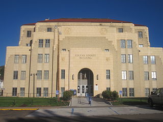
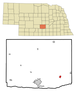
Schuyler is a city in Colfax County, Nebraska, United States. The population was 6,211 at the 2010 census. It is the county seat of Colfax County. The city is named after former Vice President of the United States, Schuyler Colfax.

<span class="mw-page-title-main">Kimball, Nebraska</span> City in and county seat of Kimball County, Nebraska, United States

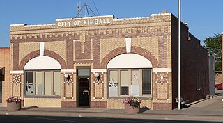
Kimball is a city in and county seat of Kimball County, Nebraska, United States. The population was 2,290 at the 2020 census.

<span class="mw-page-title-main">Colfax, Wisconsin</span> Village in Wisconsin, United States

Colfax is a village in Dunn County, Wisconsin, United States. The population was 1,158 at the 2010 census. The village is surrounded by the Town of Colfax.

References

  1. "Colfax County, Nebraska". United States Census Bureau . Retrieved June 16, 2023.
  2. "Find a County". National Association of Counties. Archived from the original on May 31, 2011. Retrieved June 7, 2011.
  3. Bain, David Haward (2004). The Old Iron Road: An Epic of Rails, Roads, and the Urge to Go West. New York City NY: Penguin Books. pp. 65–6. ISBN   0-14-303526-6.
  4. Bowman, J. R. (1882). Shearer, Frederick E. (ed.). The Pacific tourist. J.R. Bowman's illustrated transcontinental guide of travel from the Atlantic to the Pacific Ocean. New York: J.R. Bowman. p. 26. OCLC   752667534 . Retrieved May 9, 2018.
  5. "Colfax County History". www.colfaxne.com. Retrieved December 8, 2017.
  6. Griepentrog, Harold. "Schuyler: Colfax County".
  7. See "Coronavirus in the U.S.: Latest Map and Case Count" The New York Times May 15, 2020.
  8. "Nebraska Covid Map and Case Count". The New York Times. ISSN   0362-4331 . Retrieved October 4, 2020.
  9. "2010 Census Gazetteer Files". US Census Bureau. August 22, 2012. Archived from the original on November 13, 2013. Retrieved December 6, 2014.
  10. "US Decennial Census". US Census Bureau. Retrieved December 6, 2014.
  11. "Historical Census Browser". University of Virginia Library. Archived from the original on August 11, 2012. Retrieved December 6, 2014.
  12. "Population of Counties by Decennial Census: 1900 to 1990". US Census Bureau. Retrieved December 6, 2014.
  13. "Census 2000 PHC-T-4. Ranking Tables for Counties: 1990 and 2000" (PDF). US Census Bureau. Archived (PDF) from the original on March 27, 2010. Retrieved December 6, 2014.
  14. "State & County QuickFacts". US Census Bureau. Archived from the original on June 7, 2011. Retrieved September 17, 2013.
  15. "P004HISPANIC OR LATINO, AND NOT HISPANIC OR LATINO BY RACE [73] - Colfax County, Nebraska". United States Census Bureau .
  16. "P2 HISPANIC OR LATINO, AND NOT HISPANIC OR LATINO BY RACE - 2010: DEC Redistricting Data (PL 94-171) - Colfax County, Nebraska". United States Census Bureau .
  17. "P2 HISPANIC OR LATINO, AND NOT HISPANIC OR LATINO BY RACE - 2020: DEC Redistricting Data (PL 94-171) - Colfax County, Nebraska". United States Census Bureau .
  18. "U.S. Census website". US Census Bureau. Retrieved January 31, 2008.
  19. Election Results

41°35′N97°05′W / 41.58°N 97.09°W / 41.58; -97.09