Bethel (CDP), Connecticut

Last updated
Bethel, Connecticut
View of Bethel, Conn. LOC 88694060.jpg
1879 sketch of Bethel
Fairfield County Connecticut incorporated and unincorporated areas Bethel (CDP) highlighted.svg
Bethel (CDP), Connecticut
Coordinates: 41°22′15″N73°24′50″W / 41.37083°N 73.41389°W / 41.37083; -73.41389
State Connecticut
County Fairfield
Town Bethel
Area
  Total4.09 sq mi (10.59 km2)
  Land4.09 sq mi (10.59 km2)
  Water0.0 sq mi (0.0 km2)
Elevation
384 ft (117 m)
Population
 (2010)
  Total9,549
  Density2,335/sq mi (901.4/km2)
ZIP Code
06801
FIPS code 09-04790
GNIS feature ID2378335

Bethel is a census-designated place (CDP) in Fairfield County, Connecticut, United States. It comprises the primary village and surrounding residential land within the town of Bethel. As of the 2010 census, the population of the CDP was 9,549, [1] out of 18,584 in the entire town.

Contents

Geography

The Bethel CDP is in the western part of the town of Bethel, and is bordered to the west by the city of Danbury. The CDP extends north to East Swamp Brook and east to Wolf Pit Brook. The southern border of the CDP follows (from east to west) parts of Putnam Park Road, Hoyts Hill, Governors Lane, Whippoorwill Road, Winthrop Road, Spring Hill Lane, Whippoorwill Road again, Chestnut Ridge Road, Nashville Road Exd, Nashville Road, Turkey Plain Road, Grassy Plain Street, 2nd Lane, Francis J Clarke Circle and an unnamed brook back to the Danbury border. [2]

Connecticut Route 53 passes through the west side of the community, leading north into downtown Danbury and south 13 miles (21 km) to Weston. Connecticut Route 302 runs east–west through the center of town, following Greenwood Avenue and part of Milwaukee Avenue. It continues east 6 miles (10 km) to Newtown. Connecticut Route 58 has its northern terminus at Route 302 in the eastern part of the CDP, and leads southeast 18 miles (29 km) to Fairfield at the Bridgeport border.

According to the U.S. Census Bureau, the Bethel CDP has an area of 4.1 square miles (10.6 km2), all of it recorded as land. [3] Brooks in the community flow north to the Still River in Danbury, a north-flowing tributary of the Housatonic River.

Demographics

As of the census of 2010, there were 9,549 people, 3,903 households, and 2,451 families residing in the CDP. The population density was 2,335 inhabitants per square mile (902/km2). There were 4,168 housing units, of which 265, or 6.4%, were vacant. The racial makeup of the CDP was 84.8% White, 2.6% African American, 0.1% Native American or Alaska Native, 5.8% Asian, 4.4% some other race, and 2.3% from two or more races. Hispanic or Latino of any race were 10.4% of the population. [1]

Of the 3,903 households in the community, 32.9% had children under the age of 18 living with them, 46.4% were headed by married couples living together, 11.9% had a female householder with no husband present, and 37.2% were non-families. 31.1% of all households were made up of individuals, and 11.2% were someone living alone who was 65 years of age or older. The average household size was 2.44, and the average family size was 3.09. [1]

22.4% of the CDP population were under the age of 18, 7.8% were from 18 to 24, 28.9% were from 25 to 44, 29.5% were from 45 to 64, and 11.7% were 65 years of age or older. The median age was 39.5 years. For every 100 females, there were 90.9 males. For every 100 females age 18 and over, there were 87.6 males. [1]

For the period 2013–17, the estimated median annual income for a household in the CDP was $76,636, and the median income for a family was $100,938. Per capita income was $41,813. Male full-time workers had a median income of $52,050 versus $31,458 for females. About 1.9% of families and 2.9% of the population were living below the poverty line, including 2.3% of those under age 18 and 4.6% of those age 65 and over. [4]

Related Research Articles

<span class="mw-page-title-main">Broad Brook, Connecticut</span> Census-designated place in Connecticut, United States

Broad Brook is a neighborhood and census-designated place (CDP) in the town of East Windsor, Hartford County, Connecticut, United States. As of the 2010 census, the CDP population was 4,069.

<span class="mw-page-title-main">Thompsonville, Connecticut</span> Census-designated place in Connecticut, United States

Thompsonville is a census-designated place (CDP) in the town of Enfield in Hartford County, Connecticut, United States. The population of the CDP was 8,577 at the 2010 census.

<span class="mw-page-title-main">Weatogue, Connecticut</span> Census-designated place in Connecticut, United States

Weatogue is a village and census-designated place in Simsbury, Hartford County, Connecticut. The population was 2,776 at the 2010 census.

<span class="mw-page-title-main">Northwest Harwinton, Connecticut</span> Census-designated place in Connecticut, United States

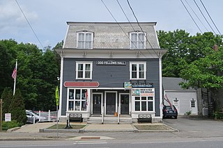
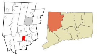
Northwest Harwinton is a census-designated place (CDP) in the town of Harwinton in Litchfield County, Connecticut, United States. The population was 3,158 at the 2020 census, out of 5,484 in the entire town. The CDP contains the town center.

<span class="mw-page-title-main">Simsbury Center, Connecticut</span> Census-designated place in Connecticut, United States

Simsbury Center is a census-designated place (CDP) that consists of the central settlement, and the neighborhoods immediately surrounding it, in the town of Simsbury, Connecticut, in the United States. As of the 2010 census, the CDP had a population of 5,836. The core area of the CDP is listed as the Simsbury Center Historic District on the National Register of Historic Places.

<span class="mw-page-title-main">Bethel, Connecticut</span> Town in Connecticut, United States

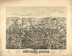
Bethel is a town in Fairfield County, Connecticut, United States. As of the 2020 census, the population of the town was 20,358. The town is part of the Western Connecticut Planning Region. The town includes the Bethel Census-Designated Place.

<span class="mw-page-title-main">Ridgefield (CDP), Connecticut</span> Census-designated place in Connecticut, United States

Ridgefield is a census-designated place (CDP) in Fairfield County, Connecticut, United States. It consists of the primary central village in the town of Ridgefield and surrounding residential areas. As of the 2020 census, the population of the CDP was 7,596, out of 25,053 in the entire town.

<span class="mw-page-title-main">New Milford (CDP), Connecticut</span> Census-designated place in Connecticut, United States

Downtown New Milford is a district/census-designated place (CDP) in Litchfield County, Connecticut, United States. It comprises the main population center within the town of New Milford. As of the 2010 census, the population of Downtown New Milford was 6,523, out of 28,142 in the entire town of New Milford.

<span class="mw-page-title-main">Marlborough (CDP), New Hampshire</span> Census-designated place in New Hampshire, United States

Marlborough is a census-designated place (CDP) and the main village in the town of Marlborough in Cheshire County, New Hampshire, United States. The population of the CDP was 1,066 at the 2020 census, out of 2,096 in the entire town.

<span class="mw-page-title-main">Winchester (CDP), New Hampshire</span> Census-designated place in New Hampshire, United States

Winchester is a census-designated place (CDP) and the main village in the town of Winchester in Cheshire County, New Hampshire, United States. The population of the CDP was 1,606 at the 2020 census, compared to 4,150 in the entire town.

Gorham is a census-designated place (CDP) and the main village in the town of Gorham in Coos County, New Hampshire, United States. The population of the CDP was 1,851 at the 2020 census, out of 2,698 people in the entire town of Gorham.

Hanover is a census-designated place (CDP) and the main village in the town of Hanover in Grafton County, New Hampshire, United States. The population of the CDP was 9,078 at the 2020 census, out of 11,870 in the entire town. The CDP includes the campus of Dartmouth College.

Lisbon is a census-designated place (CDP) and the main village in the town of Lisbon in Grafton County, New Hampshire, United States. The population of the CDP was 965 at the 2020 census, out of 1,621 in the entire town.

<span class="mw-page-title-main">Londonderry (CDP), New Hampshire</span> Census-designated place in New Hampshire, United States

Londonderry is a census-designated place (CDP) within the town of Londonderry in Rockingham County, New Hampshire, United States. The population of the CDP was 11,645 at the 2020 census, out of 25,826 in the entire town.

<span class="mw-page-title-main">Charlestown (CDP), New Hampshire</span> Census-designated place in New Hampshire, United States

Charlestown is a census-designated place (CDP) and the main village in the town of Charlestown, Sullivan County, New Hampshire, United States. The population of the CDP was 1,078 at the 2020 census, out of 4,806 in the entire town.

<span class="mw-page-title-main">Bethlehem Village, Connecticut</span> Census-designated place in Connecticut, United States

Bethlehem Village is a census-designated place (CDP) within the town of Bethlehem in Litchfield County, Connecticut, United States. The CDP includes the Bethlehem Green Historic District at the town center, as well as surrounding residential and rural land. As of the 2010 census, the CDP had a population of 2,021, out of a population of 3,607 for the entire town of Bethlehem.

<span class="mw-page-title-main">Troy (CDP), New Hampshire</span> Census-designated place in New Hampshire, United States

Troy is a census-designated place (CDP) and the main village in the town of Troy in Cheshire County, New Hampshire, United States. The population of the CDP was 1,108 at the 2020 census, compared to 2,130 in the entire town. The center of the CDP is the Troy Village Historic District.

<span class="mw-page-title-main">Manchester (CDP), Connecticut</span> Census-designated place in Connecticut, United States

Manchester is a census-designated place (CDP) in Hartford County, Connecticut, United States, comprising the urban center of the town of Manchester. As of the 2010 census, the population of the CDP was 30,577, out of 58,241 in the entire town.

<span class="mw-page-title-main">Watertown (CDP), Connecticut</span> Census-designated place in Connecticut, United States

Watertown is a census-designated place (CDP) in Litchfield County, Connecticut, United States. It comprises the central village of the town of Watertown. As of the 2010 census, the population of the CDP was 3,574, out of 22,514 in the entire town. As of the 2020 Census, the population was 22,105.

<span class="mw-page-title-main">Norfolk (CDP), Connecticut</span> Census-designated place in Connecticut, United States

Norfolk is a census-designated place (CDP) in Litchfield County, Connecticut, United States. It is the central village within the town of Norfolk. As of the 2010 census, the population of the CDP was 553, out of 1,709 in the entire town.

References

  1. 1 2 3 4 "Profile of General Population and Housing Characteristics: 2010 Census Summary File 1 (DP-1), Bethel CDP, Connecticut". American FactFinder. U.S. Census Bureau. Archived from the original on February 13, 2020. Retrieved November 1, 2019.
  2. "TIGERweb: Bethel CDP, Connecticut". U.S. Census Bureau Geography Division. Retrieved November 5, 2019.
  3. "U.S. Gazetteer Files: 2019: Places: Connecticut". U.S. Census Bureau Geography Division. Retrieved November 5, 2019.
  4. "Bethel CDP, Connecticut: ACS 5-Year Estimates Subject Tables (2017)". data.census.gov. Retrieved November 5, 2019.