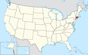
Connecticut is the southernmost state in the New England region of the Northeastern United States. It borders Rhode Island to its east, Massachusetts to its north, New York to its west, and Long Island Sound to its south. Its capital is Hartford, and its most populous city is Bridgeport. Historically, the state is part of New England as well as the tri-state area with New York and New Jersey. The state is named for the Connecticut River which approximately bisects the state. The word Connecticut is derived from various anglicized spellings of Quinnetuket, a Mohegan-Pequot word for "long tidal river". As of the 2020 United States census, Connecticut was home to over 3.6 million residents, its highest decennial count ever, growing every decade since 1790.

Fairfield County is a county in the southwestern corner of the U.S. state of Connecticut. It is the most populous county in the state and was also its fastest-growing from 2010 to 2020. As of the 2020 census, the county's population was 957,419, representing 26.6% of Connecticut's overall population. The closest to the center of the New York metropolitan area, the county contains four of the state's top 7 largest cities—Bridgeport (1st), Stamford (2nd), Norwalk (6th), and Danbury (7th)—whose combined population of 433,368 is nearly half the county's total population.

New Haven County is a county in the south central part of the U.S. state of Connecticut. As of the 2020 census, the population was 864,835, making it the third-most populous county in Connecticut. Two of the state's top 5 largest cities, New Haven (3rd) and Waterbury (5th), are part of New Haven County.

In the United States, a county or county equivalent is an administrative or political subdivision of a U.S. state or other territories of the United States which consists of a geographic area with specific boundaries and usually some level of governmental authority. The term "county" is used in 48 states, while Louisiana and Alaska have functionally equivalent subdivisions called parishes and boroughs, respectively. The specific governmental powers of counties vary widely between the states, with many providing some level of services to civil townships, municipalities, and unincorporated areas. Certain municipalities are in multiple counties; New York City is uniquely partitioned into five counties, referred to at the city government level as boroughs. Some municipalities have been consolidated with their county government to form consolidated city-counties, or have been legally separated from counties altogether to form independent cities. Conversely, those counties in Connecticut, Rhode Island, eight of Massachusetts's 14 counties, and Alaska's Unorganized Borough have no government power, existing only as geographic distinctions.
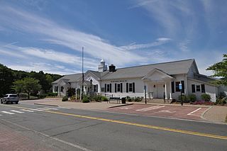
New Fairfield is a town in Fairfield County, Connecticut, United States. The population was 13,579 at the 2020 census. New Fairfield is one of five towns that surround Candlewood Lake, the largest lake in Connecticut. The town is located 55 miles (89 km) northeast of New York City, making it part of the New York metropolitan area. The town is part of the Western Connecticut Planning Region.
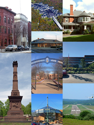
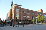
Danbury is a city in Fairfield County, Connecticut, located approximately 50 miles (80 km) northeast of New York City. Danbury's population as of 2020 was 86,518. It is the third-largest city in Western Connecticut, and the seventh-largest city in Connecticut.

Stamford-Bridgeport-Norwalk is a metropolitan area in the U.S. state of Connecticut. The area is located in Southwestern Connecticut. In its most conservative form the area consists of the city of Bridgeport and five surrounding towns—Easton, Fairfield, Monroe, Stratford, and Trumbull. This definition of the Stamford area has a population of more than 305,000 and is within the Stamford -Bridgeport-Norwalk-Danbury metropolitan statistical area, which consists of all of Fairfield County, Connecticut. The estimated 2015 county population was 948,053. The area is numbered as part of the New York-Newark Combined Statistical Area NY-NJ-CT-PA by the United States Census Bureau.
Connecticut shares with the five other New England states a governmental structure known as the New England town. From 1666 to 1960, Connecticut had a system of county governments, which each had limited powers given to it by the General Assembly. They were abolished by Public Act 152 in 1960. Connecticut also had a system of sheriffs' offices until October 2000, when those were also abolished.

Greater Danbury, also known as the Housatonic Valley Region, is a region in the state of Connecticut centered on the city of Danbury. It consists of the city of Danbury and adjacent towns in the areas around the Housatonic River and the Still River. The area is also home to Candlewood Lake, the largest lake in the New York metropolitan area.
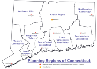
In Connecticut, councils of governments, also known as COGs, are regional planning organizations that bring together the chief elected officials or professional managers from member municipalities in Connecticut. Since 2015 and 2022, the Connecticut planning regions served by COGs have been recognized as county equivalents under state and federal law respectively, superseding the eight legacy counties in the state for most federal funding and statistical purposes.

The Northeastern Connecticut Planning Region is a planning region and county-equivalent in Connecticut. It is served by the coterminous Northeastern Connecticut Council of Governments (NECCOG). In 2022, planning regions were approved to replace Connecticut's counties as county-equivalents for statistical purposes, with full implementation occurring by 2024.

The Capitol Planning Region is a planning region and county-equivalent in Connecticut. It is served by the coterminous Capitol Region Council of Governments (CRCOG). In 2022, planning regions were approved to replace Connecticut's counties as county-equivalents for statistical purposes, with full implementation occurring by 2024.

The Greater Bridgeport Planning Region is a planning region and county-equivalent in Connecticut. It is served by the coterminous Connecticut Metropolitan Council of Governments (MetroCOG). In 2022, planning regions were approved to replace Connecticut's counties as county-equivalents for statistical purposes, with full implementation occurring by 2024.

The Lower Connecticut River Valley Planning Region is a planning region and county-equivalent in Connecticut. It is served by the coterminous Lower Connecticut River Valley Council of Governments (RiverCOG). In 2022, planning regions were approved to replace Connecticut's counties as county-equivalents for statistical purposes, with full implementation occurring by 2024.

The Naugatuck Valley Planning Region is a planning region and county-equivalent in Connecticut. It is served by the coterminous Naugatuck Valley Council of Governments (NVCOG). In 2022, planning regions were approved to replace Connecticut's counties as county-equivalents for statistical purposes, with full implementation occurring by 2024.

The Northwest Hills Planning Region is a planning region and county-equivalent in Connecticut, United States. It is served by the coterminous Northwest Hills Council of Governments (NHCOG). In 2022, planning regions were approved to replace Connecticut's counties as county-equivalents for statistical purposes, with full implementation occurring by 2024.

The South Central Connecticut Planning Region is a planning region in the Councils of governments in Connecticut and a county-equivalent in Connecticut. It is served by the coterminous South Central Regional Council of Governments (SCRCOG). In 2022, planning regions were approved to replace Connecticut's counties as county-equivalents for statistical purposes, with full implementation occurring by 2024.

The Southeastern Connecticut Planning Region is a planning region and county-equivalent in Connecticut. It is served by the coterminous Southeastern Connecticut Council of Governments (SCCOG). In 2022, planning regions were approved to replace Connecticut's counties as county-equivalents for statistical purposes, with full implementation occurring by 2024.