North Branford, Connecticut

Last updated

North Branford, Connecticut
Town of North Branford
North Branford Town Hall 099.JPG
North Branford Town Hall
N Branford CT lg.PNG
North Branford, Connecticut
Coordinates: 41°21′25″N72°46′05″W / 41.35694°N 72.76806°W / 41.35694; -72.76806
CountryFlag of the United States.svg  United States
U.S. state Flag of Connecticut.svg  Connecticut
County New Haven
Region South Central CT
Incorporated1831
Government
  Type Council-manager
  Town managerMichael Downes
  Town councilJeffrey Macmillen, Mayor
Thomas Zampano, Deputy Mayor
Bruce Abelson
Rose Marie Angeloni
Marie Diamond
Nick Palladino
Walter Goad
Vincent Mase Sr.
Ronald Pelliccia Jr.
Area
  Total26.7 sq mi (69.2 km2)
  Land24.9 sq mi (64.5 km2)
  Water1.7 sq mi (4.5 km2)
Elevation
107 ft (35 m)
Population
 (2020)
  Total13,544
  Density510/sq mi (200/km2)
Time zone UTC-5 (Eastern)
  Summer (DST) UTC-4 (Eastern)
ZIP code
06471, 06472
Area code(s) 203/475
FIPS code 09-53890
GNIS feature ID0213477
Website www.northbranfordct.gov

North Branford is a town in New Haven County, Connecticut, United States. The town is part of the South Central Connecticut Planning Region. The population was 13,544 at the 2020 census. [1] The town is primarily known for agriculture and for other points of interest including Lake Gaillard and Northford Ice Pavilion. Wallingford, Durham, and North Haven border it to the north- East Haven to the west, Guilford to the east, and Branford to the south.

Contents

The town has the neighborhoods of Totoket, Wood Chase, Sea Hill, Twin Lakes, Ashley Park, and Doral Farms. North Branford also includes the village of Northford.

History

This early mill and farming community incorporated from Branford in 1831. [2] The year prior, Maltby Fowler had opened a button-making shop. Its success along with the inventiveness of his six sons—who devised a range of machines to produce such things as screws, embossed silk, pins, and horseshoe nails—saw the rise of new manufactures along the town's Farm River. By the early 1900s, North Branford's abundant supply of trap rock, a material used for making roadways, made quarrying a growth industry. Today, the town's manufacturing sector is concentrated in electronics and electronic components.

Geography

According to the United States Census Bureau, the town has a total area of 26.6 square miles (69.0 km2), of which 24.9 square miles (64.5 km2) is land and 1.7 square miles (4.5 km2) (6.49%) is water. Neighboring towns are Wallingford and Durham to the north, Guilford to the east, Branford to the south, and North Haven and East Haven to the west.

Much of the town's acreage is dominated by Totoket Mountain, part of the Metacomet Ridge, a mountainous trap rock ridgeline that stretches from Long Island Sound almost to the Vermont border. The north side of Saltonstall Mountain is also located in North Branford. Totoket Mountain contains Lake Gaillard, a reservoir, formed in 1926, managed by the South Central Connecticut Regional Water Authority (SCCRWA). The SCCRWA maintains a network of hiking trails on Totoket Mountain in the Big Gulph area of Northford. The SCCRWA is said to own one-third of the town's area.

Totoket Mountain, 720 feet high, is the highest point of the town in the Northford neighborhood.

Demographics

Historical population
CensusPop.Note
1850 998
1860 1,0505.2%
1870 1,035−1.4%
1880 1,025−1.0%
1890 825−19.5%
1900 814−1.3%
1910 8332.3%
1920 1,11033.3%
1930 1,32919.7%
1940 1,4388.2%
1950 2,01740.3%
1960 6,771235.7%
1970 10,77859.2%
1980 11,5547.2%
1990 12,99612.5%
2000 13,9067.0%
2010 14,4073.6%
2020 13,544−6.0%
U.S. Decennial Census [3]

As of the census [4] of 2000, there were 13,906 people (6,303 of which reside in the village of Northford), 5,132 households, and 3,869 families residing in the town. The population density was 558.0 inhabitants per square mile (215.4/km2). There were 5,246 housing units at an average density of 210.5/sq. mi. (81.3/km2). The racial makeup of the town was 96.50% White, Hispanic or Latino of any race were 1.80% of the population, 1.19% African American, 0.92% Asian, 0.84% from two or more races, 0.06% Native American, and 0.02% Pacific Islander.

There were 5,132 households, of which 35.4% had children under the age of 18 living with them, 64.2% were married couples living together, 8.0% had a female householder with no husband present, and 24.6% were nonfamilies. 20.5% of all households were made up of individuals, and 10.2% had someone living alone who was 65 years of age or older. The average household size was 2.70, and the average family size was 3.15.

In the town, the population was spread out, with 25.6% under the age of 18, 5.7% from 18 to 24, 29.5% from 25 to 44, 25.5% from 45 to 64, and 13.7% who were 65 years of age or older; the median age was 39 years. For every 100 females, there were 94.2 males; for every 100 females age 18 and over, there were 90.9 males.

The median income for a household in the town was $64,438, and the median income for a family was $71,813. Males had a median income of $46,852 versus $33,469 for females. The per capita income for the town was $28,542. About 1.2% of families and 1.6% of the population were below the poverty line, including 0.9% of those under age 18 and 3.7% of those age 65 or over.

The Totoket, an Algonkian speaking native tribe, lived in the Branford and North Branford area.

Education

The high school in town is North Branford High School; their athletic teams are known as the North Branford Thunderbirds. The middle school is North Branford Intermediate School; it has just recently undergone a new construction project which renovated an existing structure and added approximately 35,000 square feet (3,300 m2) to the school. Their teams are known as the North Branford Thunderbirds. There are two elementary schools, Jerome Harrison (JHS) and Totoket Valley (TVES). In mid- 2010, the decision was made to rearrange grades and close the Stanley T. Williams elementary school in Northford.

Historical preservation

Headquartered in town is the Totoket Historical Society, Inc. Founded in 1958 as the Northford Historical Institute, the society runs four historic buildings in town: the Reynolds Beers House (the main museum and office), the Miller Barn, the "Little White Gas Station", and the Little Red Schoolhouse. THS has a collection of local historical artifacts, many now being digitized. The Society's vast collection includes items such as historical photographs, business documents and ledgers, and documents relating to land transfer and the incorporation of the town, as well as many more assorted documents. In the Miller Barn is a collection of vintage farm equipment.

The Reynolds-Beers House is open regularly, and other Society buildings are opened to the public on predetermined dates or by appointment.

Notable locations

Commerce

North Branford contains many commercial offices, such as Tilcon, Fire-Lite Alarms, and many more businesses located on major roads in North Branford and Northford.

Notable people

Related Research Articles

<span class="mw-page-title-main">Middlesex County, Connecticut</span> County in Connecticut, United States

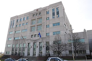
Middlesex County is a county in the south central part of the U.S. state of Connecticut. As of the 2020 census, the population was 164,245. The county was created in May 1785 from portions of Hartford County and New London County.

<span class="mw-page-title-main">New Haven County, Connecticut</span> County in Connecticut, United States

New Haven County is a county in the south central part of the U.S. state of Connecticut. As of the 2020 census, the population was 864,835, making it the third-most populous county in Connecticut. Two of the state's top 5 largest cities, New Haven (3rd) and Waterbury (5th), are part of New Haven County.

<span class="mw-page-title-main">Berlin, Connecticut</span> Town in Connecticut, United States

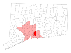
Berlin is a town in the Capitol Planning Region, Connecticut, United States. The population was 20,175 at the 2020 census. It was incorporated in 1785. The geographic center of Connecticut is located in the town. Berlin is residential and industrial, and is served by the Amtrak station of the same name. Berlin also has two hamlets: Kensington and East Berlin.

<span class="mw-page-title-main">Plainville, Connecticut</span> Town in Connecticut, United States

Plainville is a town in Hartford County, Connecticut, United States. The town is part of the Capitol Planning Region. The population was 17,525 at the 2020 census.

<span class="mw-page-title-main">Bantam, Connecticut</span> Borough in Connecticut, United States

Bantam is a borough in Litchfield County, Connecticut, United States. The population was 759 at the 2010 census.

<span class="mw-page-title-main">New Hartford, Connecticut</span> Town in Connecticut, United States

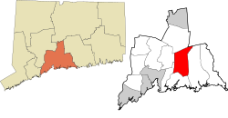
New Hartford is a town in Litchfield County, Connecticut, United States. The population was 6,658 at the 2020 census. The town is part of the Northwest Hills Planning Region. The town center is defined by the U.S. Census Bureau as the New Hartford Center census-designated place (CDP). The town is mainly a rural community consisting of farms, homes, and parks. Brodie Park and Ski Sundown are located in New Hartford.

<span class="mw-page-title-main">Branford, Connecticut</span> Town in Connecticut, United States

Branford is a shoreline town located on Long Island Sound in New Haven County, Connecticut, United States, about 6 miles (10 km) east of downtown New Haven. The town is part of the South Central Connecticut Planning Region. Branford borders East Haven on the West,Guilford on the East and to the north is North Branford. Branford is home to one of the Best 8th grade youth football teams in the SYFC.The population was 28,273 at the 2020 census.

<span class="mw-page-title-main">Guilford, Connecticut</span> Town in Connecticut, United States

Guilford is a town in New Haven County, Connecticut, United States, that borders Madison, Branford, North Branford and Durham, and is situated on I-95 and the Connecticut seacoast. The town is part of the South Central Connecticut Planning Region. The population was 22,073 at the 2020 census.

<span class="mw-page-title-main">Oxford, Connecticut</span> Town in Connecticut, United States

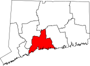
Oxford is a residential town located in western New Haven County, Connecticut, United States. The town is part of the Naugatuck Valley Planning Region. The population was 12,706 at the 2020 Census. Oxford is the 26th-wealthiest town in the state by median household income. Distinct settled areas in the town include Oxford Center, Quaker Farms, and Riverside. Oxford belongs to the Bridgeport–Stamford–Norwalk Metropolitan Statistical Area, a subregion of the New York metropolitan area.

<span class="mw-page-title-main">Wallingford, Connecticut</span> Town in Connecticut, United States

Wallingford is a town in New Haven County, Connecticut, United States, centrally located between New Haven and Hartford, and Boston and New York City. The town is part of the South Central Connecticut Planning Region. The population was 44,396 at the 2020 census. The community was named after Wallingford, in England.

<span class="mw-page-title-main">Bozrah, Connecticut</span> Town in Connecticut, United States

Bozrah is a town in New London County, Connecticut, United States. The town is part of the Southeastern Connecticut Planning Region. The population was 2,429 at the 2020 census. Bozrah contains three villages: Fitchville, the town center; Leffingwell, a crossroads on Route 82; and Gilman, a mill village along Fitchville Road.

<span class="mw-page-title-main">Branford Center, Connecticut</span> United States historic place

Branford Center is a neighborhood and census-designated place (CDP) in the town of Branford, Connecticut, United States. The CDP encompasses the traditional town center area and the area known as Branford Point. The population of the CDP was 5,819 at the 2010 census.

<span class="mw-page-title-main">Burke, Vermont</span> Town in Vermont, United States

Burke is a town in Caledonia County, Vermont, United States. The population was 1,651 at the 2020 census. The town contains the villages of East Burke, West Burke and Burke Hollow. The town is home to Burke Mountain and Burke Mountain Academy.

<span class="mw-page-title-main">Maidstone, Vermont</span> Town in Vermont, United States

Maidstone is a town in Essex County, Vermont, United States. As of the 2020 census, the town had a population of 211. It is part of the Berlin, NH–VT Micropolitan Statistical Area. There is no town center or gas station, but there is a town office building in the southern part of the town.

<span class="mw-page-title-main">Peach Lake, New York</span> CDP in New York, United States

Peach Lake is a hamlet located mostly in the town of Southeast in Putnam County, New York, United States; a portion of the CDP is in the town of North Salem in Westchester County. As of the 2010 census, the population was 1,629.

<span class="mw-page-title-main">Durham, Connecticut</span> Town in Connecticut, United States

Durham is a town in Middlesex County, Connecticut, United States. Durham is a former farming village on the Coginchaug River in central Connecticut. The town is part of the Lower Connecticut River Valley Planning Region. The population was 7,152 at the 2020 census. Every autumn, the town hosts the Durham Fair, the largest volunteer agricultural fair in New England.

<span class="mw-page-title-main">Totoket Mountain</span> Traprock massif near New Haven, Connecticut

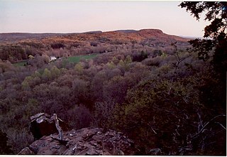
Totoket Mountain, with a high point of (est.) 720 ft (220 m) above sea level, is a traprock massif with several distinct summits, located 7 mi (11 km) northeast of New Haven, Connecticut. It is part of the Metacomet Ridge that extends from the Long Island Sound near New Haven, north through the Connecticut River Valley of Massachusetts to the Vermont border. Totoket Mountain is known for its 500 ft-high (150 m) scenic cliffs, microclimate ecosystems, rare plant communities, and for Lake Gaillard, a 2.5 mi-wide (4.0 km) public reservoir nearly enclosed by the mountain. The north ridge of Totoket Mountain is traversed by the 50 mi (80 km) Mattabesett Trail and a significant network of shorter trails. The name "Totoket Mountain" applies to both the entire mountain and to a subordinate northwestern peak.

<span class="mw-page-title-main">Saltonstall Mountain</span> Traprock mountain ridge in the American state of Connecticut

Saltonstall Mountain, also known as Saltonstall Ridge, with a high point of (est.) 320 feet (98 m) above sea level, is a traprock mountain ridge located 3 miles (5 km) east of New Haven, Connecticut and 1.75 miles (2.8 km) north of Long Island Sound. It is part of the Metacomet Ridge that extends from Long Island Sound near New Haven, Connecticut, north through the Connecticut River Valley of Massachusetts to the Vermont border. Saltonstall Mountain is known for its 100 foot (30 m) scenic cliff faces and sharp ridgeline, unique microclimate ecosystems, rare plant communities, and for Lake Saltonstall, a 3 miles (5 km) long by 0.3 miles (400 m) wide municipal reservoir nearly enclosed by the mountain. Saltonstall Mountain is traversed by a number of hiking trails managed by the South Central Connecticut Regional Water Authority (SCCRWA) and Branford Land Trust.

<span class="mw-page-title-main">Clinton, Connecticut</span> Town in Connecticut, United States

Clinton is a town in Middlesex County, Connecticut, United States. The town is part of the Lower Connecticut River Valley Planning Region. The population of the town was 13,185 at the 2020 census. The town center along the shore line was listed as a census-designated place (CDP) by the U.S. Census Bureau in the 2020 census.

Lake Gaillard in North Branford, Connecticut, began during the 1920s, when the New Haven Water Company started buying land in North Branford from the area of Totoket Mountain to what is now known as Sea Hill Road, with the intention of building a reservoir. "The regional water authority currently owns 34.9% of the land within North Branford, most of these holdings surrounds Lake Gaillard, the largest reservoir within the Regional Water Authority’s water supply."

References

  1. "Census - Geography Profile: North Branford town, New Haven County, Connecticut" . Retrieved December 18, 2021.
  2. The Connecticut Magazine: An Illustrated Monthly. Connecticut Magazine Company. 1903. p. 333.
  3. "Census of Population and Housing". Census.gov. Retrieved June 4, 2015.
  4. "U.S. Census website". United States Census Bureau . Retrieved January 31, 2008.