Chaplin, Connecticut

Last updated

Chaplin, Connecticut
Town of Chaplin
Goodell Lincoln General Store, Chaplin CT.jpg
Goodell Lincoln General Store
ChaplinCTseal.JPG
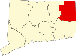
Windham County Connecticut incorporated and unincorporated areas Chaplin highlighted.svg
Chaplin, Connecticut
Coordinates: 41°48′N72°8′W / 41.800°N 72.133°W / 41.800; -72.133
CountryFlag of the United States.svg  United States
U.S. state Flag of Connecticut.svg  Connecticut
County Windham
Region Northeastern CT
Incorporated1822
Government
  Type Selectman-town meeting
  First selectmanJuan Roman III (R)
  SelectmanKenneth Fortier (R)
  SelectmanJoe Pinto (D)
Area
  Total19.6 sq mi (50.8 km2)
  Land19.4 sq mi (50.3 km2)
  Water0.1 sq mi (0.3 km2)
Elevation
390 ft (119 m)
Population
  Total2,151
  Density110/sq mi (42/km2)
Time zone UTC-5 (EST)
  Summer (DST) UTC-4 (EDT)
ZIP code
06235
Area code(s) 860/959
FIPS code 09-13810
GNIS feature ID0213405
Website chaplinct.org

Chaplin is a town in Windham County, Connecticut, United States. The town is part of the Northeastern Connecticut Planning Region. The town was named for Deacon Benjamin Chaplin, an early settler. [1] The population was 2,151 at the 2020 census. [2]

Contents

Points of interest

Geography

According to the United States Census Bureau, the town has a total area of 19.6 square miles (51 km2), of which, 19.4 square miles (50 km2) is land and 0.1 square miles (0.26 km2) (0.66%) is water.

Principal communities

Demographics

Historical population
CensusPop.Note
1850 796
1860 781−1.9%
1870 704−9.9%
1880 627−10.9%
1890 542−13.6%
1900 529−2.4%
1910 435−17.8%
1920 385−11.5%
1930 4147.5%
1940 48918.1%
1950 71245.6%
1960 1,23072.8%
1970 1,62131.8%
1980 1,79310.6%
1990 2,04814.2%
2000 2,2509.9%
2010 2,3052.4%
2020 2,151−6.7%
U.S. Decennial Census [4]

At the 2000 census there were 2,250 people, 858 households, and 614 families living in the town. The population density was 115.8 inhabitants per square mile (44.7/km2). There were 897 housing units at an average density of 46.2 per square mile (17.8/km2). The racial makeup of the town was 97.29% White, 0.71% African American, 0.27% Native American, 0.36% Asian, 0.31% from other races, and 1.07% from two or more races. Hispanic or Latino people of any race were 1.96%. [5]

Of the 858 households 33.6% had children under the age of 18 living with them, 58.6% were married couples living together, 9.1% had a female householder with no husband present, and 28.4% were non-families. 20.4% of households were one person and 5.7% were one person aged 65 or older. The average household size was 2.62 and the average family size was 3.03.

The age distribution was 24.6% under the age of 18, 7.6% from 18 to 24, 34.5% from 25 to 44, 25.1% from 45 to 64, and 8.1% 65 or older. The median age was 37 years. For every 100 females, there were 102.3 males. For every 100 females age 18 and over, there were 99.8 males.

The median household income was $51,602 and the median family income was $55,263. Males had a median income of $39,300 versus $30,430 for females. The per capita income for the town was $22,101. About 2.9% of families and 2.9% of the population were below the poverty line, including 0.9% of those under age 18 and 11.0% of those age 65 or over.

Voter registration and party enrollment as of October 29, 2019 [6]
PartyActive votersInactive votersTotal votersPercentage
Republican 487649330.91%
Democratic 4391245128.28%
Unaffiliated 6121963139.56%
Minor parties 200201.25%
Total1,558371,595100%
Presidential Election Results [7] [8]
Year Democratic Republican Third Parties
2020 46.4% 59851.3%6622.3% 30
2016 37.8% 43454.4%6247.8% 89
2012 54.4%58443.4% 4662.2% 24
2008 59.0%66339.2% 4401.8% 20
2004 52.0%59044.5% 5053.5% 30
2000 49.8%51638.9% 40311.3% 118
1996 45.5%41830.0% 27624.5% 225
1992 39.2%41725.9% 27634.9% 371
1988 49.7%42049.1% 3151.2% 10
1984 37.7% 29462.1%4840.2% 1
1980 33.9% 26149.0%37817.1% 132
1976 47.2% 33452.3%3700.5% 3
1972 45.4% 33954.2%4040.4% 3
1968 46.9% 30548.8%3174.3% 28
1964 69.5%46030.5% 2020.00% 0
1960 41.1% 28958.9%3660.00% 0
1956 28.8% 14271.2%3650.00% 0

Notable people

Related Research Articles

<span class="mw-page-title-main">Deep River, Connecticut</span> Town in Connecticut, United States

Deep River is a town in Middlesex County, Connecticut. The town is part of the Lower Connecticut River Valley Planning Region. The population was 4,415 at the 2020 census. The town center is designated by the U.S. Census Bureau as a census-designated place (CDP). Deep River is part of what the locals call the "Tri-town Area", made up of the towns of Deep River, Chester, and Essex.

<span class="mw-page-title-main">Westbrook, Connecticut</span> Town in Connecticut, United States

Westbrook is a town in Middlesex County, Connecticut, United States. The town is part of the Lower Connecticut River Valley Planning Region. The population was 6,769 at the 2020 census. The town center is classified by the U.S. Census Bureau as a census-designated place (CDP).

<span class="mw-page-title-main">Franklin, Connecticut</span> Town in Connecticut, United States

Franklin is a town in New London County, Connecticut, United States. The town is part of the Southeastern Connecticut Planning Region. The population was 1,863 at the 2020 census. The town includes the village of North Franklin.

<span class="mw-page-title-main">Voluntown, Connecticut</span> Town in Connecticut, United States

Voluntown is a town in New London County, Connecticut, United States. The town is part of the Northeastern Connecticut Planning Region. The population was 2,570 at the 2020 census. Voluntown was part of Windham County from 1726 to 1881.

<span class="mw-page-title-main">Andover, Connecticut</span> Town in Connecticut, United States

Andover is a rural town in the Capitol Planning Region, Connecticut, United States, roughly 10 miles east of Hartford. The population was 3,151 at the 2020 census. Andover is home to Andover Elementary School for grades K–6 while grades 7–12 go to R.H.A.M. middle and high schools. Andover elementary scores above average on standardized testing and student development as well as having a notably low student to teacher ratio of 8:1.

<span class="mw-page-title-main">Columbia, Connecticut</span> Town in Connecticut, United States

Columbia is a town in the Capitol Planning Region, Connecticut, United States. The population was 5,272 at the 2020 census. Originally a part of Lebanon, known as the North Society or Lebanon's Crank, Columbia was incorporated in May 1804. The town was named for patriotic reasons after the national symbol "Columbia". Columbia offers pre-kindergarten through 8th grade education in town at Horace W. Porter School, while high school students have a choice of attending four nearby high schools; E.O Smith High School, Bolton High School (Connecticut), Coventry High School, and Windham Technical High School, part of the Connecticut Technical High School System).

<span class="mw-page-title-main">Hebron, Connecticut</span> Town in Connecticut, United States

Hebron is a town in Tolland County, Connecticut, United States. The town is part of the Capitol Planning Region. The population was 9,098 at the 2020 census. Hebron was incorporated May 26, 1708. In 2010, Hebron was rated #6 in Top Towns in Connecticut with population between 6,500 and 10,000, according to Connecticut Magazine.

<span class="mw-page-title-main">Willington, Connecticut</span> Town in Connecticut, United States

Willington is a town in Tolland County, Connecticut, United States. The town is part of the Capitol Planning Region. The population was 5,566 at the 2020 census.

<span class="mw-page-title-main">Ashford, Connecticut</span> Town in Connecticut, United States

Ashford is a town in Windham County, Connecticut, United States. The town is part of the Northeastern Connecticut Planning Region. The population was 4,191 at the 2020 census. It was founded in 1714. Eastford was a part of Ashford until 1847, when the former split off to organize its own town. For this reason North Ashford is located in northeast Eastford.

<span class="mw-page-title-main">Brooklyn, Connecticut</span> Town in Connecticut, United States

Brooklyn is a town in Windham County, Connecticut, United States. The town is part of the Northeastern Connecticut Planning Region. The population was 8,450 at the 2020 census. The town center village is listed by the U.S. Census Bureau as a census-designated place. The district of East Brooklyn is listed as a separate census-designated place.

<span class="mw-page-title-main">Canterbury, Connecticut</span> Town in Connecticut, United States

Canterbury is a town in Windham County, Connecticut, United States. The town is part of the Northeastern Connecticut Planning Region. The population was 5,045 at the 2020 census.

<span class="mw-page-title-main">Eastford, Connecticut</span> Town in Connecticut, United States

Eastford is a town in Windham County, Connecticut, United States. The town is part of the Northeastern Connecticut Planning Region. The population was 1,649 at the 2020 census.

<span class="mw-page-title-main">Hampton, Connecticut</span> Town in Connecticut, United States

Hampton is a town in Windham County, Connecticut, United States. The town is part of the Northeastern Connecticut Planning Region. The population was 1,728 at the 2020 census.

<span class="mw-page-title-main">Killingly, Connecticut</span> Town in Connecticut, United States

Killingly is a town in Windham County, Connecticut, United States. Killingly is the largest town by population in the Northeastern Connecticut Planning Region. The population was 17,752 at the 2020 census. It consists of the borough of Danielson and the villages of Attawaugan, Ballouville, Dayville, East Killingly, Rogers, and South Killingly.

<span class="mw-page-title-main">Plainfield, Connecticut</span> Town in Connecticut, United States

Plainfield is a town in Windham County, Connecticut, United States. The town is part of the Northeastern Connecticut Planning Region. The population was 14,973 at the 2020 census. The town comprises four villages: Plainfield, Moosup, Wauregan, and Central Village. Each village has their own respective United States Post Office and fire department. The entire town is serviced by the 860 area code.

<span class="mw-page-title-main">Scotland, Connecticut</span> Town in Connecticut, United States

Scotland is a town in Windham County, Connecticut. The town is part of the Northeastern Connecticut Planning Region. As of the 2020 census, the town population was 1,576. Scotland is a predominantly rural town with agriculture as the principal industry. Scotland is the least populated town in Windham County.

<span class="mw-page-title-main">Sterling, Connecticut</span> Town in Connecticut, United States

Sterling is a town in Windham County, Connecticut, United States. The town is part of the Northeastern Connecticut Planning Region. The population was 3,578 at the 2020 census.

<span class="mw-page-title-main">Windham, Connecticut</span> Town in Connecticut, United States

Windham is a town in Windham County, Connecticut, United States. It contains the former city of Willimantic as well as the boroughs of Windham Center, North Windham, and South Windham. Willimantic, an incorporated city since 1893, was consolidated with the town in 1983. The town is part of the Southeastern Connecticut Planning Region. The population was 24,428 at the 2020 census.

<span class="mw-page-title-main">Durham, Connecticut</span> Town in Connecticut, United States

Durham is a town in Middlesex County, Connecticut, United States. Durham is a former farming village on the Coginchaug River in central Connecticut. The town is part of the Lower Connecticut River Valley Planning Region. The population was 7,152 at the 2020 census. Every autumn, the town hosts the Durham Fair, the largest volunteer agricultural fair in New England.

<span class="mw-page-title-main">Canaan, Connecticut</span> Town in Connecticut, United States

Canaan is a town in Litchfield County, Connecticut, United States. The population was 1,080 at the 2020 census, down from 1,234 at the 2010 census. The town is part of the Northwest Hills Planning Region. The town of Canaan is often referred to locally by the name of its principal settlement, Falls Village.

References

  1. The Connecticut Magazine: An Illustrated Monthly. Connecticut Magazine Company. 1903. p. 331.
  2. "Census - Geography Profile: Chaplin town, Windham County, Connecticut" . Retrieved November 27, 2021.
  3. Parsons, Greg. "Diana's Pool - Connecticut". New England Waterfalls. Retrieved April 29, 2017.
  4. "Census of Population and Housing". Census.gov. Retrieved June 4, 2015.
  5. "U.S. Census website". United States Census Bureau . Retrieved January 31, 2008.
  6. "Registration and Party Enrollment Statistics as of October 29, 2019" (PDF). Connecticut Secretary of State. Retrieved March 22, 2020.
  7. "General Election Statements of Vote, 1922 – Current". CT Secretary of State. Retrieved December 20, 2020.
  8. "Election Night Reporting". CT Secretary of State. Retrieved December 20, 2020.
  9. 'Illinois Blue Book 1906-1906,' Biographical Sketch of Charles H. Backus, pg. 266-267