Plainfield Village, Connecticut

Last updated

Plainfield Village, Connecticut
Town Hall, Plainfield CT.jpg
Plainfield Town Hall
Windham County Connecticut incorporated and unincorporated areas Plainfield Village highlighted.svg
Location in Windham County and the state of Connecticut.
Coordinates: 41°42′02″N71°53′41″W / 41.7006°N 71.8947°W / 41.7006; -71.8947
CountryUnited States
State Connecticut
Town Plainfield
Area
  Total1.7 sq mi (4 km2)
  Land1.6 sq mi (4 km2)
  Water0.04 sq mi (0.1 km2)
Elevation
171 ft (52 m)
Population
 (2010)
  Total2,557
  Density1,500/sq mi (580/km2)
Time zone UTC−5 (Eastern (EST))
  Summer (DST) UTC−4 (EDT)
ZIP code
06374
Area code 860
FIPS code09-60090
GNIS feature ID2377851 [1]

Plainfield Village is a village and census-designated place (CDP) in the town of Plainfield, Connecticut in the United States. The population was 2,557 at the 2010 census. It is located in the southwest part of town, in the area west of I-395 and south of Route 14. The village is also the core of the Plainfield, CT urban cluster.

Contents

Geography

According to the United States Census Bureau, the CDP has a total area of 1.7 square miles (4.4 km2), of which, 1.6 square miles (4.1 km2) of it is land and 0.04 square miles (0.10 km2) of it (1.80%) is water.

Demographics

As of the census [2] of 2000, there were 2,638 people, 959 households, and 648 families residing in the CDP. The population density was 1,605.5 inhabitants per square mile (619.9/km2). There were 1,007 housing units at an average density of 612.9 per square mile (236.6/km2). The racial makeup of the CDP was 94.66% White, 1.48% African American, 0.80% Native American, 0.57% Asian, 1.21% from other races, and 1.29% from two or more races. Hispanic or Latino of any race were 2.35% of the population.

There were 959 households, out of which 36.7% had children under the age of 18 living with them, 45.0% were married couples living together, 14.3% had a female householder with no husband present, and 32.4% were non-families. 24.7% of all households were made up of individuals, and 11.7% had someone living alone who was 65 years of age or older. The average household size was 2.58 and the average family size was 3.03.

In the CDP, the population was spread out, with 25.8% under the age of 18, 8.7% from 18 to 24, 30.4% from 25 to 44, 18.9% from 45 to 64, and 16.3% who were 65 years of age or older. The median age was 36 years. For every 100 females, there were 90.5 males. For every 100 females age 18 and over, there were 85.9 males.

The median income for a household in the CDP was $33,268, and the median income for a family was $40,081. Males had a median income of $29,219 versus $23,261 for females. The per capita income for the CDP was $14,836. About 7.5% of families and 9.2% of the population were below the poverty line, including 13.1% of those under age 18 and none of those age 65 or over.

Related Research Articles

<span class="mw-page-title-main">Dudleyville, Arizona</span> CDP in Pinal County, Arizona

Dudleyville is a census-designated place (CDP) in Pinal County, Arizona, United States. The population was 959 at the 2010 census.

<span class="mw-page-title-main">Mountain View, Contra Costa County, California</span> Census designated place in California, United States

Mountain View is a census designated place (CDP) in Contra Costa County, California, United States. The population was 2,372 at the 2010 census.

<span class="mw-page-title-main">Mayflower Village, California</span> Census-designated place in California, United States

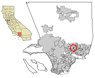
Mayflower Village is a census-designated place (CDP) in the San Gabriel Valley, in Los Angeles County, California, United States. The population was 5,515 at the 2010 census, up from 5,081 at the 2000 census. The ZIP Codes serving the community are 91006, which is served by Arcadia and 91016, which is served by Monrovia.

<span class="mw-page-title-main">Parksdale, California</span> Census-designated place in California, United States

Parksdale is a census-designated place (CDP) in Madera County, California, United States. It is part of the Madera Metropolitan Statistical Area. The population was 3,234 at the 2020 census, up from 2,621 in 2010.

Heritage Village is a census-designated place (CDP) in the town of Southbury in New Haven County, Connecticut, United States. The population was 3,736 at the 2010 census.

<span class="mw-page-title-main">Moosup, Connecticut</span> Village in Connecticut, United States

Moosup is a village and census-designated place (CDP) in the town of Plainfield, Connecticut in the United States. The population was 3,231 at the 2010 census.

<span class="mw-page-title-main">Crystal Lawns, Illinois</span> Census designated place

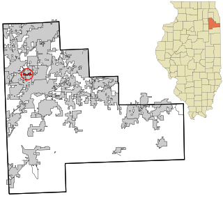
Crystal Lawns is a census-designated place (CDP) in Will County, Illinois, United States. The population was 1,830 at the 2020 census.

<span class="mw-page-title-main">Lakeland Village, California</span> Census-designated place in California, United States

Lakeland Village is a census-designated place (CDP) in Riverside County, California, United States. The population was 11,541 at the 2010 census, more than double the 5,626 reported at the 2000 census.

<span class="mw-page-title-main">Weidman, Michigan</span> Census-designated place & unincorporated community in Michigan, United States

Weidman is an unincorporated community in Isabella County, Michigan, United States. It is a census-designated place (CDP) for statistical purposes, but has no independent municipal authority. The population of the CDP was 959 at the 2010 census, up from 879 at the 2000 census.

<span class="mw-page-title-main">Grand Rapids Charter Township, Michigan</span> Charter township in Michigan, United States

Grand Rapids Charter Township is a charter township of Kent County in the U.S. state of Michigan. The population was 18,905 at the 2020 census.

<span class="mw-page-title-main">Northview, Michigan</span> Census-designated place & unincorporated community in Michigan, United States

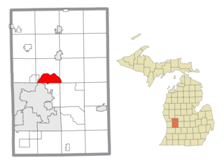
Northview is an unincorporated community and census-designated place (CDP) in Kent County in the U.S. state of Michigan. The population was 14,541 at the 2010 census. The community is located mostly within Plainfield Township with a very small portion extending into Grand Rapids Township to the south.

<span class="mw-page-title-main">Plainfield, Ohio</span> Village in Ohio, United States

Plainfield is a village in Coshocton County, Ohio, United States, along Wills Creek. The population was 141 at the 2020 census.

<span class="mw-page-title-main">Covedale, Ohio</span> Census-designated place in Ohio, United States

Covedale is a census-designated place (CDP) in Green Township, Hamilton County, Ohio, United States. The population was 6,472 at the 2020 census. The CDP represents the part of the former village of Covedale that was not annexed by the city of Cincinnati in 1930.

<span class="mw-page-title-main">Mount Healthy Heights, Ohio</span> Census-designated place in Ohio, United States

Mount Healthy Heights is a census-designated place (CDP) in Hamilton County, Ohio, United States. The population was 2,918 at the 2020 census.

<span class="mw-page-title-main">Colver, Pennsylvania</span> Census-designated place in Pennsylvania, United States

Colver is an unincorporated community and census-designated place (CDP) in Cambria County, Pennsylvania, United States. The population was 959 at the 2010 census.

<span class="mw-page-title-main">Plainfield, Pennsylvania</span> Census-designated place in Pennsylvania, United States

Plainfield is a census-designated place (CDP) in Cumberland County, Pennsylvania, United States. The population was 399 at the 2010 census. It is part of the Harrisburg–Carlisle metropolitan statistical area.

<span class="mw-page-title-main">Belfast, Pennsylvania</span> CDP in Pennsylvania, United States

Belfast is a census-designated place (CDP) in Plainfield Township in Northampton County, Pennsylvania, United States. It is part of the Lehigh Valley metropolitan area, which had a population of 861,899 and was the 68th-most populous metropolitan area in the U.S. as of the 2020 census. As of the 2010 census, the village's population was 1,257.

Plainfield is a town in Waushara County, Wisconsin, United States. The population was 533 at the 2000 census. The village of Plainfield is surrounded by the town. The ghost town of West Plainfield is located in the town.

<span class="mw-page-title-main">Plainfield, Wisconsin</span> Village in Wisconsin, United States

Plainfield is a village in Waushara County, Wisconsin, United States. The village is located almost entirely within the Town of Plainfield. A tiny portion extends into adjacent Town of Oasis. The population was 897 at the 2010 census.

Plainfield is a census-designated place (CDP) and the namesake village in the town of Plainfield, Sullivan County, New Hampshire, United States. The population of the CDP was 178 at the 2020 census, out of 2,459 in the entire town.

References

  1. U.S. Geological Survey Geographic Names Information System: Plainfield Village
  2. "U.S. Census website". United States Census Bureau . Retrieved January 31, 2008.