Bethesda, Arkansas

Last updated

Bethesda, Arkansas
USA Arkansas location map.svg
Red pog.svg
Bethesda
Bethesda's position in Arkansas
Usa edcp location map.svg
Red pog.svg
Bethesda
Bethesda (the United States)
Coordinates: 35°47′21″N91°47′57″W / 35.78917°N 91.79917°W / 35.78917; -91.79917
Country United States
State Arkansas
County Independence
Township Washington
Elevation
[1]
551 ft (168 m)
Population
 (2020)
  Total199
Time zone UTC-6 (Central (CST))
  Summer (DST) UTC-5 (CDT)
Area code 870
GNIS feature ID2805623 [1]

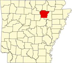
Bethesda was an unincorporated community and census-designated place (CDP) in western Independence County, Arkansas, United States. [1] It was first listed as a CDP in the 2020 census with a population of 199. [2]

Contents

It is connected to the Arkansas Highway System via Highway 106S and is approximately eight miles west of Batesville. [3]

Demographics

Historical population
CensusPop.Note
2020 199
U.S. Decennial Census [4]
2020 [5]

2020 census

Bethesda CDP, Arkansas – Demographic Profile
(NH = Non-Hispanic)
Note: the US Census treats Hispanic/Latino as an ethnic category. This table excludes Latinos from the racial categories and assigns them to a separate category. Hispanics/Latinos may be of any race.
Race / EthnicityPop 2020 [5] % 2020
White alone (NH)17688.44%
Black or African American alone (NH)00.00%
Native American or Alaska Native alone (NH)00.00%
Asian alone (NH)10.50%
Pacific Islander alone (NH)00.00%
Some Other Race alone (NH)00.00%
Mixed Race/Multi-Racial (NH)157.54%
Hispanic or Latino (any race)73.52%
Total199100.00%

Related Research Articles

Magnet Cove is a census-designated place (CDP) and former town in Hot Spring County, Arkansas, United States. It is located in the Ouachita Mountains southeast of Hot Springs, on Arkansas Highway 51 north of U.S. Highway 270. As of the 2020 census, the town of Magnet Cove had a population of 692.

<span class="mw-page-title-main">New Blaine, Arkansas</span> Census-designated place in Arkansas, United States

New Blaine is an unincorporated community and census-designated place (CDP) in Logan County, Arkansas, United States. Per the 2020 census, the population was 173.

Salado is an Incorporated community and census-designated place (CDP) in Independence County, Arkansas, United States. It was first listed as a CDP in the 2020 census with a population of 472.

Midway is a census-designated place in Baxter County, Arkansas, United States. Midway is 5.5 miles (8.9 km) northwest of Mountain Home. Per the 2020 census, the population was 1,036. Midway has a post office with ZIP code 72651.

<span class="mw-page-title-main">Kingston, Arkansas</span> Census-designated place in Arkansas, United States

Kingston is an unincorporated community and census-designated place (CDP) in northeast Madison County, Arkansas, United States. It was first listed as a CDP in the 2020 census with a population of 97.

<span class="mw-page-title-main">Pencil Bluff, Arkansas</span> Census-designated place in Arkansas, United States

Pencil Bluff is an unincorporated community and census-designated place (CDP) in Montgomery County, Arkansas, United States. Pencil Bluff is located at the junction of U.S. Route 270 and Arkansas Highway 88, 7.5 miles (12.1 km) northwest of Mount Ida. It was first listed as a CDP in the 2020 census with a population of 72.

<span class="mw-page-title-main">Evansville, Arkansas</span> Census-designated place in Arkansas, United States

Evansville is an unincorporated community and census-designated place (CDP) in southwest Washington County, Arkansas, United States. It was first listed as a CDP in the 2020 census with a population of 102.

<span class="mw-page-title-main">Yarborough Landing, Arkansas</span> Census-designated place in Arkansas, United States

Yarborough Landing is a census-designated place in Little River County, Arkansas, United States. Per the 2020 census, the population was 457.

Newhope is an unincorporated community and census-designated place (CDP) in Pike County, Arkansas, United States. Newhope is located at the junction of U.S. Route 70 and Arkansas Highway 369, 8 miles (13 km) west of Daisy. Newhope has a post office with ZIP code 71959.

Wesley is an unincorporated community and census-designated place (CDP) in western Madison County, Arkansas, United States. Wesley is located at the junction of Arkansas highways 74 and 295, 13 miles (21 km) by road west-southwest of Huntsville. Wesley has a post office with ZIP code 72773. It was first listed as a CDP in the 2020 census with a population of 161.

<span class="mw-page-title-main">Ponca, Arkansas</span> Census-designated place in Arkansas, United States

Ponca is an unincorporated community and census-designated place (CDP) in Newton County, Arkansas, United States. Ponca is located on Arkansas Highway 43, 10 miles (16 km) west of Jasper. Ponca has a post office with ZIP code 72670.

Wayton is an unincorporated community and census-designated place (CDP) in Newton County, Arkansas, United States. Wayton is located on Arkansas Highway 327, 8 miles (13 km) south-southwest of Jasper.

Lawson is an unincorporated community and census-designated place (CDP) in Union County, Arkansas, United States. Lawson was founded by Lawson Smith, who was born in 1813 and died in 1899. Lawson is located on Arkansas Highway 129, 10.5 miles (16.9 km) east of El Dorado. Lawson has a post office with ZIP code 71750. It was first listed as a CDP in the 2020 census with a population of 260.

Mellwood is an unincorporated community and census-designated place (CDP) in Phillips County, Arkansas, United States. Mellwood is located on Arkansas Highway 44, 8.5 miles (13.7 km) southwest of Elaine. Mellwood has a post office with ZIP code 72367. It was first listed as a CDP in the 2020 census with a population of 21.

Hattieville is an unincorporated community and census-designated place (CDP) in Conway County, Arkansas, United States. It was first listed as a CDP in the 2020 census with a population of 132. Hattieville is located on Arkansas Highway 213, 9.5 miles (15.3 km) north-northwest of Morrilton. Hattieville has a post office with ZIP code 72063.

Monroe is an unincorporated community and census-designated place (CDP) in Monroe County, Arkansas, United States. The unincorporated community extends beyond the CDP slightly into Lee County. It was first listed as a CDP in the 2020 census with a population of 51.

Batavia is an unincorporated community and census-designated place (CDP) in Boone County, Arkansas, United States. It was first listed as a CDP in the 2020 census with a population of 328.

Mount Olive is an unincorporated community and census-designated place (CDP) in Izard County, Arkansas, United States. Mount Olive is located on the White River, 11.1 miles (17.9 km) west-southwest of Melbourne.

Lacey is an unincorporated community and census-designated place (CDP) in Drew County, Arkansas, United States. Lacey is located at the junction of U.S. Route 425 and Arkansas Highway 133, 12.4 miles (20.0 km) south-southwest of Monticello. It was first listed as a CDP in the 2020 census with a population of 139.

Aplin is an unincorporated community and census-designated place (CDP) in Perry County, Arkansas, United States. It was first listed as a CDP in the 2020 census with a population of 100. The community is located along Arkansas Highway 60, 10.3 miles (16.6 km) west-southwest of Perryville.

References

  1. 1 2 3 U.S. Geological Survey Geographic Names Information System: Bethesda, Arkansas
  2. "Bethesda CDP, Arkansas". United States Census Bureau . Retrieved April 7, 2022.
  3. Arkansas Atlas & Gazetteer, DeLorme, 2nd ed., 2004, p. 34 ISBN   0-89933-345-1
  4. "Decennial Census of Population and Housing by Decades". US Census Bureau.
  5. 1 2 "P2 HISPANIC OR LATINO, AND NOT HISPANIC OR LATINO BY RACE – 2020: DEC Redistricting Data (PL 94-171) – Bethesda CDP, Arkansas". United States Census Bureau .