Desha, Arkansas | |
|---|---|
 Desha  Desha | |
| Coordinates: 35°43′50″N91°41′08″W / 35.73056°N 91.68556°W | |
| Country | United States |
| State | Arkansas |
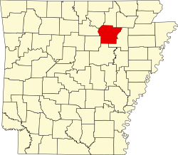
| County | Independence |
| Elevation | 299 ft (91 m) |
| Population (2020) | |
• Total | 715 |
| Time zone | UTC-6 (Central (CST)) |
| • Summer (DST) | UTC-5 (CDT) |
| ZIP code | 72527 |
| Area code | 870 |
| GNIS feature ID | 2805636 [1] |
Desha is an unincorporated community and census-designated place (CDP) in Independence County, Arkansas, United States. It was first listed as a CDP in the 2020 census with a population of 715. [2]
Contents
Desha is located along Arkansas Highway 25, 3 miles (4.8 km) southwest of Batesville. Desha has a post office with ZIP code 72527. [3]
Batesville School District operates area public schools. The Desha School District merged into the Batesville district on July 1, 1985. [4]