Bexhill West railway station

Last updated

Bexhill West
West Station, 16 Terminus Road, Bexhill.jpg
General information
Location Bexhill-on-Sea, Rother, East Sussex
England
Grid reference TQ736076
Platforms3
Other information
StatusDisused
History
Original company Crowhurst, Sidley and Bexhill Railway
Pre-grouping South Eastern and Chatham Railway
Post-grouping Southern Railway
Southern Region of British Railways
Key dates
1 June 1902 [1] Opened as Bexhill
1 January 1917Closed
1 March 1919Reopened
1920Renamed Bexhill-on-Sea
9 July 1923Renamed Bexhill (Eastern)
November 1929Renamed Bexhill West
9 September 1963 [2] Goods facilities withdrawn
15 June 1964Closed to passengers

Bexhill West is a closed station in Bexhill-on-Sea in East Sussex. It was the terminus of the Bexhill West branch of the Hastings Line. It was opened by the South Eastern and Chatham Railway and was operated by the Southern Region of British Railways on closing. The station building still survives as an antiques house. The trackbed and site of the now demolished platforms are now occupied by commercial industrial buildings.

Contents

History

A 4.5-mile (7.2 km) branch line was ceremonially opened between Crowhurst and Bexhill on 31 May 1902 by the nominally independent Crowhurst, Sidley & Bexhill Railway Company which had been promoted by the Earl De La Warr together with other local businessmen and landowners. The line had the backing of the South Eastern Railway which ran services to the nearby Hastings and St Leonards stations. [3] The branch would offer a quicker route to Bexhill than that already provided by the London, Brighton and South Coast Railway whose own Bexhill station on the Hastings to Brighton line had opened more than fifty years earlier. The new Bexhill terminus would be 62 miles (100 km) from Charing Cross, while the LB&SCR's station was 71.75 miles (115.47 km) from Victoria. [4] The branch was absorbed by the South Eastern and Chatham Railway in 1905. [5]

The new Bexhill station was situated in a valley on the west side of Bexhill which had not yet been developed. It was approached by a new road named "Terminus Road" to distinguish it from the "Station Road" which served the LB&SCR's station. A lavish station building was constructed which reflected the SER's ambitions for the line. Designed by C.S. Barry and C.E. Mercer, it was built of yellow and red brick and Bath Stone dressing. Welsh slate was used on the roof which is crowned by a clocktower, and the main entrance features a block-moulded pediment which was carved in situ. The symmetrical building comprised a large and airy booking hall, ticket and parcels offices, a waiting room and ladies toilet, as well as the stationmaster's and inspector's offices. At a right angle to the building stands a smaller block which contained a refreshment room, gents' toilet, porters' and lamp rooms. [6] Two 700-foot-long (210 m) and 30-foot-wide (9.1 m) island platforms were provided, those to the east (nos. 1 and 2) covered by a glass canopy extending to a distance of 400 feet (120 m) and also covering the concourse between the tracks and building. The uncovered platforms 3 and 4 were rarely used; platform 4 never in fact received any track and platform 3 was soon covered by grass. The station buildings were lit by electricity, whereas the platforms by gas. A goods depot was opened on London Road opposite the York Hotel, where a brick shed measuring 133 feet 6 inches (40.69 m) by 30 feet (9.1 m) was erected. [7]

Despite the shorter route to London and the impressive station buildings, passengers continued to prefer the LB&SCR's more centrally-located station. In 1917, the Railway Executive Committee ordered the closure of the branch from January 1917. Although goods services began again from November 1917, full passenger services were not restored until March 1919. The 1923 grouping led to the SE&CR becoming part of the Southern Railway which renamed the LB&SCR station "Bexhill Central" whilst the SER's station became simply "Bexhill" and finally "Bexhill West" in November 1929. [8] The Southern arranged for most main line services through Crowhurst to include three corridor coaches for Bexhill West to avoid the need to change trains, but this still failed to tempt passengers on to the branch. In 1930, consultants engaged by Bexhill Town Council recommended the construction of a link line between the two lines, but nothing came of this nor of the proposal in 1937 to electrify the line at the same time as the Hastings Line. Although now very much referred to as a branch, the line temporarily took on main line status when services on the Hastings Line were temporarily diverted to Bexhill West between 27 November 1949 and 5 June 1950 while Bo-peep tunnel was closed for partial reconstruction. Emergency bus services ran from Crowhurst to St Leonards, Hastings and Bexhill West. Services on the East Coastway Line terminated at St Leonards West Marina. [9] The line's push-pull trains were replaced in June 1958 by two-car diesel-electric units which connected with the London to Hastings diesel-electric units at Crowhurst. Sunday services were withdrawn from January 1960. The line's demise was confirmed by its inclusion in the Beeching Report, and it finally closed to all traffic from 15 June 1964. [10] [11]

Preceding station Disused railways Following station
Terminus  British Rail
Southern Region

Bexhill West Branch Line
  Sidley

Present day

The track was lifted in 1965 and the bridge over Down Road and Little Common Road demolished in 1967. Bexhill West station building has survived and is now occupied by Sivyers Antique Emporium and Auction, along with Brief Encounters Cafe. The adjoining former refreshment rooms are now a pub and restaurant, and the engine shed forms part of the light industrial estate now occupying the former trackbed to the rear of the station along Beeching Road. [12] The platforms have been demolished.

The building was listed at Grade II by English Heritage on 27 February 2013. [13] This status is given to "nationally important buildings of special interest". [14]

Photographs

Related Research Articles

<span class="mw-page-title-main">London Victoria station</span> London Underground and railway station

Victoria station, also known as London Victoria, is a central London railway terminus and connected London Underground station in Victoria, in the City of Westminster, managed by Network Rail. Named after the nearby Victoria Street, the main line station is a terminus of the Brighton Main Line to Gatwick Airport and Brighton and the Chatham Main Line to Ramsgate and Dover via Chatham. From the main lines, trains can connect to the Catford Loop Line, the Dartford Loop Line, and the Oxted line to East Grinstead and Uckfield. Southern operates most commuter and regional services to south London, Sussex and parts of east Surrey, while Southeastern operates trains to south-east London and Kent, alongside limited services operated by Thameslink. Gatwick Express trains run direct to Gatwick. The Underground station is on the Circle and District lines between Sloane Square and St James's Park, and the Victoria line between Pimlico and Green Park. The area around the station is an important interchange for other forms of transport: a local bus station is in the forecourt and Victoria Coach Station is nearby.

<span class="mw-page-title-main">London, Brighton and South Coast Railway</span> British pre-grouping railway company

The London, Brighton and South Coast Railway was a railway company in the United Kingdom from 1846 to 1922. Its territory formed a rough triangle, with London at its apex, practically the whole coastline of Sussex as its base, and a large part of Surrey. It was bounded on its western side by the London and South Western Railway (L&SWR), which provided an alternative route to Portsmouth. On its eastern side the LB&SCR was bounded by the South Eastern Railway (SER)—later one component of the South Eastern and Chatham Railway (SE&CR)—which provided an alternative route to Bexhill, St Leonards-on-Sea, and Hastings. The LB&SCR had the most direct routes from London to the south coast seaside resorts of Brighton, Eastbourne, Worthing, Littlehampton and Bognor Regis, and to the ports of Newhaven and Shoreham-by-Sea. It served the inland towns and cities of Chichester, Horsham, East Grinstead and Lewes, and jointly served Croydon, Tunbridge Wells, Dorking and Guildford. At the London end was a complicated suburban and outer-suburban network of lines emanating from London Bridge and Victoria, and shared interests in two cross-London lines.

<span class="mw-page-title-main">East Croydon station</span> National rail station and Tramlink tram stop in London

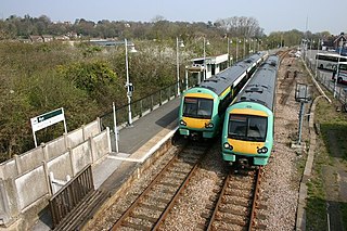
East Croydon is a railway station and tram stop in Croydon, Greater London, England, and is located in Travelcard Zone 5. At 10 miles 28 chains from London Bridge, it is one of the busiest non-terminal stations in London, and in the United Kingdom as a whole. It is one of three railway stations in the London Borough of Croydon with Croydon in their name, the others being West Croydon and South Croydon. A Tramlink tram stop is located immediately outside the main station entrance.

<span class="mw-page-title-main">South Eastern Railway (England)</span> British pre-grouping railway company

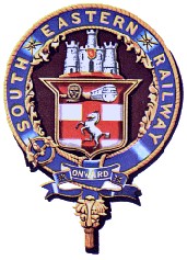
The South Eastern Railway (SER) was a railway company in south-eastern England from 1836 until 1922. The company was formed to construct a route from London to Dover. Branch lines were later opened to Tunbridge Wells, Hastings, Canterbury and other places in Kent. The SER absorbed or leased other railways, some older than itself, including the London and Greenwich Railway and the Canterbury and Whitstable Railway. Most of the company's routes were in Kent, eastern Sussex and the London suburbs, with a long cross-country route from Redhill in Surrey to Reading, Berkshire.

<span class="mw-page-title-main">Oxted line</span> National Rail line in southern England

The Oxted line is a railway in southern England and part of the Southern franchise. The railway splits into two branches towards the south and has direct trains throughout to London termini.

<span class="mw-page-title-main">Marshlink line</span> Railway line in South East England

The Marshlink line is a railway line in South East England. It runs from Ashford, Kent via Romney Marsh, Rye and the Ore Tunnel to Hastings where it connects to the East Coastway line towards Eastbourne. Services are provided by Southern.

<span class="mw-page-title-main">East Coastway line</span> Railway line in Sussex, England

The East Coastway line is a railway line along the south coast of Sussex to the east of Brighton, England. Trains to the west of Brighton operate on the West Coastway line. Together with the West Coastway and the Marshlink line to the east, the line forms part of a continuous route from Havant to Ashford. The Brighton Main Line route to Eastbourne and Hastings, via Plumpton and Cooksbridge, shares the East Coastway line east of Lewes station.

<span class="mw-page-title-main">Crowhurst railway station</span> Railway station on the main London - Tunbridge Wells - Hastings line in East Sussex in England

Crowhurst railway station is on the Hastings line in the south of England and serves the village of Crowhurst, East Sussex. It is 57 miles 50 chains (92.7 km) down the line from London Charing Cross. The station and all trains serving it are operated by Southeastern.

<span class="mw-page-title-main">Eastbourne railway station</span> Railway station in East Sussex, England

Eastbourne railway station serves the seaside town of Eastbourne in East Sussex, England. It is on the East Coastway Line. The station is managed by Southern, who operate all trains serving it. It is one of two railway stations in the town, the other being Hampden Park Station. There are also two other stations in the Eastbourne area, one being Pevensey & Westham, in nearby Westham, the other being Polegate.

<span class="mw-page-title-main">Tunbridge Wells West railway station</span> Station in Kent, England

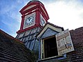
Tunbridge Wells West is a railway station located in Royal Tunbridge Wells, Kent. It is one of two railway stations in Tunbridge Wells constructed by rival companies. The other, Tunbridge Wells Central was opened in 1845 by the South Eastern Railway (SER). Tunbridge Wells West was closed to mainline passenger services in 1985, but part of it still remains as a heritage railway line. Opened in 1996, it stands next to the original engine shed. The line is called the Spa Valley Railway.

<span class="mw-page-title-main">Tongham railway station</span> Former English railway station

Tongham railway station was a railway station serving the village of Tongham, Guildford, Surrey in England which opened in 1856 and closed in 1937.

<span class="mw-page-title-main">Dungeness railway station (South Eastern Railway)</span> Former railway station in England

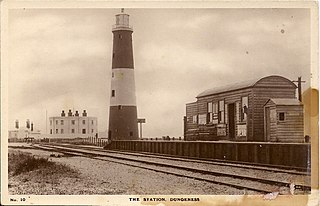
Dungeness was a railway station which served the Dungeness headland in Kent, England. Opened in 1883 by The Lydd Railway Company, it closed to passengers in 1937. Part of the line which served the station is converted to the main access road as a means of transporting atomic waste from nearby Dungeness nuclear power station.

<span class="mw-page-title-main">St Leonards West Marina railway station</span> Disused railway station in East Sussex, England

St Leonards West Marina is a disused railway station in the West St Leonards area of the borough of Hastings, East Sussex. Opened by the Brighton, Lewes and Hastings Railway in 1846 as part of what became the East Coastway Line, it was the first permanent station to serve the area and became part of a feud between two rival railway companies over access to nearby Hastings. Although ultimately inconvenient for local services, the station became an important goods railhead and the location of a motive power depot for locomotives working express services to London. The station was closed in 1967 and subsequently demolished, although in 2011 remnants of the down platform could still be seen.

Bulverhythe was a temporary railway station on the Brighton Lewes and Hastings Railway in Bulverhythe, now part of Hastings, East Sussex.

<span class="mw-page-title-main">Brookland Halt railway station</span> Disused railway station in England

Brookland Halt was a railway station which served the village of Brookland in Kent, England. The station opened in 1881 and closed in 1967.

<span class="mw-page-title-main">Hartington Road Halt railway station</span> Former railway station in England

Hartington Road Halt railway station was a stop on the Kemp Town branch railway line between Brighton station and Kemp Town, Brighton, East Sussex. It was open only briefly between 1906 and 1911. The line it stood on was closed permanently in 1971 and has now been demolished.

<span class="mw-page-title-main">New Romney and Littlestone-on-Sea railway station</span> Former railway station in England

New Romney and Littlestone-on-Sea was a railway station which lay in between the villages of New Romney and Littlestone-on-Sea in Kent, England. The station opened in 1884 and closed in 1967.

<span class="mw-page-title-main">Junction Road Halt railway station</span> Railway station in Bodiam, Rother, England

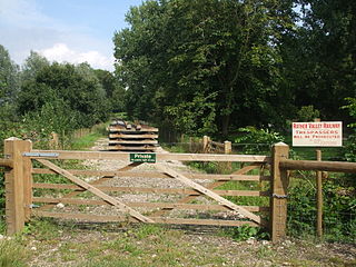
Junction Road Halt, also known as Junction Road (for Hawkhurst), was a halt station on the Kent and East Sussex Railway. It was located on the eastern side of the level crossing across the B2244 Junction Road near the hamlet of Udiam in East Sussex, England. Closed for passengers in 1954 and freight in 1961 with the line, The line through Junction Road Halt may yet be revived as the Rother Valley Railway, a preservation society, is proposing to reopen the line from Robertsbridge to Bodiam.

<span class="mw-page-title-main">Bexhill West branch line</span>

The Bexhill West branch line was a short double-track branch line which was opened on 1 June 1902. It was built by the Crowhurst, Sidley & Bexhill Railway under the patronage of the South Eastern Railway. The Chief Engineer to the project was Lt Col Arthur John Barry. Diverging from the Hastings Line at Crowhurst, an intermediate station at Sidley was served before the terminus was reached at Bexhill West. The line was closed under the Beeching Axe on 15 June 1964.

<span class="mw-page-title-main">Bricklayers Arms railway station</span> Disused railway station in England

Bricklayers Arms was a railway station in Southwark opened by the London and Croydon Railway and the South Eastern Railway in 1844 as an alternative to the London and Greenwich Railway's terminus at London Bridge. The station was at the end of a short branch line from the main line to London Bridge and served as a passenger terminus for a few years before being converted to a goods station and engineering facility. The goods station closed in 1981.

References

  1. Butt, R.V.J. (1995). The Directory of Railway Stations, Patrick Stephens Ltd, Sparkford, ISBN   1-85260-508-1, p. 33.
  2. Clinker, C.R. (October 1978). Clinker's Register of Closed Passenger Stations and Goods Depots in England, Scotland and Wales 1830-1977. Bristol: Avon-AngliA Publications & Services. p. 12. ISBN   0-905466-19-5.
  3. Harding, Peter A. (2002). The Bexhill West branch line. Woking: Peter A. Harding. pp. 4–5. ISBN   0-9523458-6-2.
  4. White, H.P. (1986). Forgotten Railways: South-East England (Forgotten Railways Series). Newton Abbot, Devon: David & Charles. p. 102. ISBN   0-946537-37-2.
  5. White, H.P. (1992). A Regional History of the Railways of Great Britain: Southern England (Vol. 2). Nairn, Scotland: David St John Thomas. p. 36. ISBN   0-946537-77-1.
  6. Harding, P., pp. 23-24.
  7. Course, Edwin (1974). The Railways of Southern England: Secondary and Branch Lines. London: B.T. Batsford Ltd. p. 200. ISBN   0-7134-2835-X.
  8. Course, E. (1974), p. 202.
  9. Course, Edwin (1973). The Railways of Southern England: the Main Lines. London: B.T. Batsford Ltd. pp. 111–112. ISBN   0-7134-0490-6.
  10. Harding, P., pp. 16-17.
  11. Oppitz, Leslie (2001). Lost Railways of Sussex (Lost Railways). Newbury, Berks: Countryside Books. p. 147. ISBN   1-85306-697-4.
  12. White, H.P. (1986), p. 175.
  13. Historic England. "Former Bexhill West Station, 15 Terminus Road, Bexhill on Sea, East Sussex (Grade II) (1412228)". National Heritage List for England . Retrieved 28 February 2013.
  14. "Listed Buildings". English Heritage. 2012. Archived from the original on 26 January 2013. Retrieved 28 February 2013.

Coordinates: 50°50′27″N0°27′48″E / 50.840871°N 0.463369°E / 50.840871; 0.463369