St Leonards West Marina railway station

Last updated

St Leonards West Marina
West Marina Station.jpg
West Marina Station
General information
Location West St Leonards, Hastings, East Sussex
England
Grid reference TQ787089
Platforms2
Other information
StatusDisused
History
Original company Brighton, Lewes and Hastings Railway
Pre-grouping London, Brighton and South Coast Railway
Post-grouping Southern Railway
Southern Region of British Railways
Key dates
7 November 1846Opened as Hastings & St Leonard's
13 February 1851Renamed St Leonards
5 December 1870Renamed St Leonards West Marina
1 June 1889Rebuilt on adjacent site to the east
10 November 1962Closed to goods traffic
10 July 1967Closed to passengers
Railway stations
in Hastings
BSicon CONTg.svg
BSicon HST.svg
Ore
BSicon TUNNEL1.svg
Mount Pleasant Tunnel (
230 yd
210 m
)
BSicon ACC.svg
Hastings
BSicon tSTRa.svg
Hastings Tunnel (
788 yd
721 m
)
BSicon CONTg.svg
BSicon tSTR.svg
BSicon STR.svg
BSicon tHSTACCea.svg
St Leonards Warrior Square
BSicon HST.svg
BSicon tSTR.svg
West St Leonards
BSicon STR.svg
BSicon tSTRe.svg
Bopeep Tunnel (
1318 yd
1205 m
)
BSicon STRl.svg
BSicon ABZgr.svg
BSicon eBHF.svg
St Leonards West Marina
BSicon eHST.svg
Bulverhythe
BSicon eHST.svg
Glyne Gap Halt
BSicon CONTf.svg

St Leonards West Marina is a disused railway station in the Bopeep area of the borough of Hastings, East Sussex. Opened by the Brighton, Lewes and Hastings Railway in 1846, it was the first permanent station to serve the area and became part of a feud between two rival railway companies over access to nearby Hastings. Although not very convenient for local services, the station became an important goods rail-head and the location of a Motive Power Depot for steam locomotives working non electrified services, including those to London. The station was closed in 1967 and the buildings subsequently demolished, although in 2023 the down platform could still be seen.

Contents

History

Opening

On 27 June 1846, the Brighton Lewes & Hastings Railway (BL&H) opened from Bexhill to a temporary station at Bulverhythe. [1] [2] [3] [4] The short delay was caused by the diversion of the River Asten / Combe Haven and the subsequent bridgework having to be completed. Bulverhythe Temporary Station was replaced on 7 November 1846 by a permanent station named Hastings & St Leonards which was situated approximately 1 Mile east. [5] [6] [4] [2]

LB&SCR and SER feud

The BL&H had powers to extend the line to a junction with the South Eastern Railway (SER) at Ashford, thereby creating a coastal route from Brighton to Dover of strategic military importance to the government. [2] [7] [8] The SER took advantage of the government's desire for the line by offering to construct the section between Hastings and Ashford in return for powers to build the North Kent Line, which resulted in the government agreeing to authorise the Hastings-Ashford line provided the SER extended its Tonbridge-Tunbridge Wells line to Hastings. [9] In view of the low revenue earning potential of a Hastings-Ashford line with Rye the largest settlement to be served, the BL&H agreed to transfer ownership of the section to the SER whilst retaining the right to exercise running powers as far as Hastings. [10] [9] [11]

The BL&H had been taken over by the London, Brighton and South Coast Railway (LB&SCR) on 27 July 1846, [12] which decided to exercise the right to run as far as Hastings. [13] This would give it a route from London Bridge to St Leonards of 76.5 miles (123.1 kilometres), somewhat shorter than the SER's circuit of 93 miles (150 kilometres) travelling via Redhill and Tonbridge and then Ashford. [13] [8] A crisis was therefore triggered when the SER's line to Hastings and the short stretch from St Leonards opened simultaneously on 13 February 1851. [14] [15] The SER made it difficult for LB&SCR services to use the new line by holding up a train for so long at Bo-peep junction that it was obliged to return to St Leonards and unload its passengers. [8] [16] Later, the SER tore up track at Bo-Peep and obstructed the line with wagons filled with earth. [17] [18] [19] [20]

A 1914 Railway Clearing House map of lines around St Leonards. Hastings & St Leonards RJD 100 - excerpt.jpg
A 1914 Railway Clearing House map of lines around St Leonards.

An injunction obtained by the LB&SCR ensured the reopening of the line and the two companies began to share traffic receipts, culminating in an agreement in 1866 by which St Leonards Warrior Square, the SER's intermediate station between Hastings and the LB&SCR's St Leonards station, became a joint station and facilities were provided here and at Hastings to allow joint SER/LB&SCR operation of the line. [21] [19] LB&SCR services were nevertheless not allowed to call at Warrior Square until December 1870, at which point the LB&SCR changed the name of its own St Leonards station to St Leonards West Marina. [22] [5] [6]

Post-feud to closure

West Marina was inconveniently situated for local traffic but as it was the only station in the area under the LB&SCR's exclusive control, the station was retained and even developed to become a rail-head for goods traffic. [3] The LB&SCR tried to improve access in 1882 when a new station was built on an adjacent site to the east. [6] [5] [23] [24] The station was provided with a coal yard with sidings, freight sheds and a 49 ft 11 in (15.21 m) turntable. [25] [26]

The stations' importance fell after the 1921 grouping, although it retained a certain importance until the late 1950s as a locomotive depot. [3] Following electrification of the East Coastway line in 1935 by the Southern Railway, the service pattern introduced from May saw express trains from London Victoria call at all stations except West Marina. [27] Nevertheless, the station became the terminus for London services in November 1949 when it was necessary to close Bopeep Tunnel for repairs; buses ferried passengers from West Marina to St Leonards Warrior Square. [28] [29] Normal services through the tunnel resumed on 5 June 1950. [28] Remarkably the now dilapidated station remained open to passengers until 10 July 1967, [6] [22] [19] [30] the station's goods yard already having closed on 26 November 1962. [31] For several years after closure the station platforms remained available for use of railway staff requiring access to the depot.

Motive power depot

Platform remains in 2007. Site of West Marina Station - geograph.org.uk - 526216.jpg
Platform remains in 2007.
Site of West Marina Station in the distance. The right hand track curves around the remains of the down platform. St Leonards West Marina Railway Station.jpg
Site of West Marina Station in the distance. The right hand track curves around the remains of the down platform.

A motive power depot was established at the station by the LB&SCR in 1846 on the Down side of the line to the west of the Bo-Peep tunnel. [3] [32] [33] The depot served the Hastings area and was a small two-road shed, constructed in brick with a turntable on the northern side. [32] This was replaced by a second larger 4-road shed in 1872, which was enlarged in 1898 and again by British Railways in 1949. [34] [33] In 1926, the shed had 62 staff including 20 drivers and firemen. [35] Following the demolition of the ex-SER shed at Hastings, West Marina shed grew in importance as it took over the former shed's entire allocation in 1929. [32] [36] A new wheel drop facility was fitted in the same year to assist with the increased workload, as were additional carriage sidings. [32] [36] The first of 12 SR V Schools class locomotives arrived in 1931, adding to the shed's 20-odd 4-4-0s, F1s, Ls and a handful of tank and 0-6-0s. [32] The Schools class were used to work Hastings Line expresses to London. [3] As of January 1947, its allocation consisted of 30 locomotives: 20 4-4-0s, 5 0-4-4Ts and 5 0-6-0s. [37]

Following nationalisation, the shed was given the code 74E [38] and it received a new asbestos roof with brick gables. [32] However, by 1957 the depot's role was much reduced as a result of the first stages of dieselisation which had led to the closure of the servicing point at Hastings station and the withdrawal of most of St Leonards' engines. [32] Further dieselisation resulted in the depot's effective closure in June 1958, although engines continued to be serviced and stabled until 10 November 1967. [34] [32] [31] The bulk of the shed's remaining allocation was transferred to Ashford, Brighton, Tonbridge and Tunbridge Wells West. [33] The depot has now been completely demolished. [32] A new diesel depot was opened to the west of the old steam motive power depot. [3]

Preceding station Historical railways Following station
Glyne Gap Halt
Line open, station closed
  London, Brighton and South Coast Railway
East Coastway Line
  St Leonards Warrior Square
Line and station open

Present day

The station buildings were demolished following closure and the site is now the car park of a TK Maxx warehouse store. [3] Where the engine sheds stood, is now a train washing facility which was built in 1958; [19] [33] TK Maxx and a row of houses now stand where the coal yard and freight sheds once stood. The remains of both platforms can also still be seen. [24] [25]

Related Research Articles

<span class="mw-page-title-main">New Cross Gate railway station</span> London Overground station

New Cross Gate is a railway station in New Cross, London, on the Brighton Main Line and the London Overground. It is 2 miles 70 chains down the line from London Bridge and is about 600 m (660 yd) west of New Cross station. It is in Travelcard Zone 2, and is operated by London Overground.

<span class="mw-page-title-main">London, Brighton and South Coast Railway</span> British pre-grouping railway company

The London, Brighton and South Coast Railway was a railway company in the United Kingdom from 1846 to 1922. Its territory formed a rough triangle, with London at its apex, practically the whole coastline of Sussex as its base, and a large part of Surrey. It was bounded on its western side by the London and South Western Railway (L&SWR), which provided an alternative route to Portsmouth. On its eastern side the LB&SCR was bounded by the South Eastern Railway (SER)—later one component of the South Eastern and Chatham Railway (SE&CR)—which provided an alternative route to Bexhill, St Leonards-on-Sea, and Hastings. The LB&SCR had the most direct routes from London to the south coast seaside resorts of Brighton, Eastbourne, Worthing, Littlehampton and Bognor Regis, and to the ports of Newhaven and Shoreham-by-Sea. It served the inland towns and cities of Chichester, Horsham, East Grinstead and Lewes, and jointly served Croydon, Tunbridge Wells, Dorking and Guildford. At the London end was a complicated suburban and outer-suburban network of lines emanating from London Bridge and Victoria, and shared interests in two cross-London lines.

<span class="mw-page-title-main">South Eastern Railway (England)</span> British pre-grouping railway company

The South Eastern Railway (SER) was a railway company in south-eastern England from 1836 until 1922. The company was formed to construct a route from London to Dover. Branch lines were later opened to Tunbridge Wells, Hastings, Canterbury and other places in Kent. The SER absorbed or leased other railways, some older than itself, including the London and Greenwich Railway and the Canterbury and Whitstable Railway. Most of the company's routes were in Kent, eastern Sussex and the London suburbs, with a long cross-country route from Redhill in Surrey to Reading, Berkshire.

The London and Croydon Railway (L&CR) was an early railway in England. It opened in 1839 and in February 1846 merged with other railways to form the London Brighton and South Coast Railway (LB&SCR).

<span class="mw-page-title-main">Marshlink line</span> Railway line in South East England

The Marshlink line is a railway line in South East England. It runs from Ashford, Kent via Romney Marsh, Rye and the Ore Tunnel to Hastings where it connects to the East Coastway line towards Eastbourne. Services are provided by Southern.

<span class="mw-page-title-main">Hastings railway station</span> Railway station in East Sussex, England

Hastings railway station is the southern terminus of the Hastings line in the south of England and is one of four stations that serve the town of Hastings, East Sussex. It is also on the East Coastway Line to Eastbourne and the Marshlink line to Ashford International. It is 62 miles 33 chains (100.4 km) from London Charing Cross measured via Chelsfield and Battle; and 82 miles 33 chains (132.6 km) from Charing Cross via Chelsfield and Ashford.

<span class="mw-page-title-main">East Coastway line</span> Railway line in Sussex, England

The East Coastway line is a railway line along the south coast of Sussex to the east of Brighton, England. Trains to the west of Brighton operate on the West Coastway line. Together with the West Coastway and the Marshlink line to the east, the line forms part of a continuous route from Havant to Ashford. The Brighton Main Line route to Eastbourne and Hastings, via Plumpton and Cooksbridge, shares the East Coastway line east of Lewes station.

<span class="mw-page-title-main">Ashford International railway station</span> Railway station in Kent, England

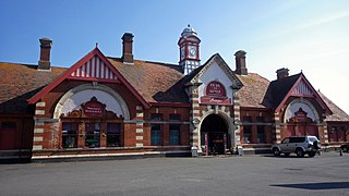
Ashford International railway station is a National Rail station in Ashford, Kent, England. It connects several railway lines, including High Speed 1 and the South Eastern Main Line. Services are operated by Southeastern and Southern.

<span class="mw-page-title-main">Queenborough railway station</span> Railway station in Kent, England

Queenborough railway station is on the Sheerness Line, on the Isle of Sheppey in northern Kent, and serves the town of Queenborough. It is 49 miles 22 chains (79.3 km) down the line from London Victoria.

<span class="mw-page-title-main">Robertsbridge railway station</span> Railway station in East Sussex, England

Robertsbridge railway station is on the Hastings line in the south of England and serves the village of Robertsbridge, East Sussex. It is 49 miles 47 chains (79.8 km) down the line from London Charing Cross. The station and all trains serving it are operated by Southeastern.

<span class="mw-page-title-main">Rye railway station (East Sussex)</span> Railway station in East Sussex, England

Rye railway station is a Grade II listed station, serving Rye, East Sussex, England. It is on the Marshlink line between Hastings and Ashford International and is the principal station between those two terminals. The station is a passing place between two single track sections. Services are provided by Southern, usually between Eastbourne and Ashford with an additional shuttle from Rye to Ashford at peak times.

<span class="mw-page-title-main">Eastbourne railway station</span> Railway station in East Sussex, England

Eastbourne railway station serves the seaside town of Eastbourne in East Sussex, England. It is on the East Coastway Line. The station is managed by Southern, who operate all trains serving it. It is one of two railway stations in the town, the other being Hampden Park Station. There are also two other stations in the Eastbourne area, one being Pevensey & Westham, in nearby Westham, the other being Polegate.

<span class="mw-page-title-main">Redhill railway station</span> Railway station in Surrey, England

Redhill railway station serves the town of Redhill, Surrey, England. The station is a major interchange point on the Brighton Main Line, 22 miles 40 chains (36.2 km) measured from London Charing Cross. It is managed by Southern, and is also served by Thameslink and GWR.

<span class="mw-page-title-main">East Grinstead railway station</span> Railway station in West Sussex, England

East Grinstead railway station is one of the two southern termini of the Oxted line in the south of England and serves East Grinstead in West Sussex. It is 30 miles 4 chains from London Bridge, although trains mostly run to and from London Victoria. The station is managed by Southern.

<span class="mw-page-title-main">South Eastern Main Line</span> Major long-distance railway line in south-east England

The South Eastern Main Line is a major long-distance railway route in South East England, UK, one of the three main routes crossing the county of Kent, going via Sevenoaks, Tonbridge, Ashford and Folkestone to Dover. The other routes are the Chatham Main Line which runs along the north Kent coast to Ramsgate or Dover via Chatham and High Speed 1 which runs through the centre of Kent to the coast at Folkestone where it joins the Channel Tunnel.

<span class="mw-page-title-main">Bexhill West railway station</span> Disused railway station in Rother, East Sussex

Bexhill West is a closed station in Bexhill-on-Sea in East Sussex. It was the terminus of the Bexhill West branch of the Hastings Line. It was opened by the South Eastern and Chatham Railway and was operated by the Southern Region of British Railways on closing. The station building still survives as an antiques house. The trackbed and site of the now demolished platforms are now occupied by commercial industrial buildings.

<span class="mw-page-title-main">Reading Southern railway station</span> Former railway station in the English town of Reading

Reading Southern railway station was opened as the western terminus of the South Eastern Railway's route from Redhill, a junction station at the time of opening known as Reigate Junction in south-east Surrey, having direct links thence to Dover port, Brighton and London Bridge. The station was referred to for exactly one century by an identical name to its neighbour, 'Reading', until 1949. Seven years after its opening the station expanded its uses by becoming the terminus of a new company's Waterloo to Reading line from London Waterloo station. This mid-length line added to the town's connections with more intermediate stops, beyond nearby Wokingham and mid-south parts of Surrey which had been directly served by the station and added a competing service, approximately one third longer in distance to a London terminus than the adjacent Great Western Railway.

<span class="mw-page-title-main">St Lawrence for Pegwell Bay railway station</span> Disused railway station in Kent, England

St Lawrence for Pegwell Bay railway station was a railway station at Ramsgate, Kent, United Kingdom that was opened by the South Eastern Railway in 1864 and closed in 1916.

<span class="mw-page-title-main">Bricklayers Arms railway station</span> Disused railway station in England

Bricklayers Arms was a railway station in Southwark opened by the London and Croydon Railway and the South Eastern Railway in 1844 as an alternative to the London and Greenwich Railway's terminus at London Bridge. The station was at the end of a short branch line from the main line to London Bridge and served as a passenger terminus for a few years before being converted to a goods station and engineering facility. The goods station closed in 1981.

<span class="mw-page-title-main">Portsmouth and Ryde Joint Railway</span>

The Portsmouth and Ryde Joint Railway was a group of three railway lines in Southern England that were jointly owned and operated by the London and South Western Railway and the London, Brighton and South Coast Railway. The main line was between Cosham and Portsmouth Harbour; there was a branch from Fratton to East Southsea; and a line between Ryde Pier Head and Ryde St John's Road. The last-named section was isolated from the others, being on the Isle of Wight. The first section of line opened in 1847 and the last in 1885; the Southsea branch closed in 1914 but all of the other routes have since been electrified and remain open.

References

Notes

  1. White 1992, p. 84.
  2. 1 2 3 Dendy Marshall & Kidner 1963a, p. 204.
  3. 1 2 3 4 5 6 7 Course 1973, p. 149.
  4. 1 2 Turner 1977, p. 223.
  5. 1 2 3 Butt 1995, p. 204.
  6. 1 2 3 4 Quick 2009, p. 341.
  7. Course 1973, pp. 109–110.
  8. 1 2 3 White 1992, p. 34.
  9. 1 2 Course 1973, p. 109.
  10. Turner 1977, p. 222.
  11. White 1992, pp. 33–34.
  12. Awdry 1990, p. 180.
  13. 1 2 Course 1973, p. 110.
  14. Turner 1977, p. 226.
  15. Dendy Marshall & Kidner 1963b, p. 302.
  16. Body 1989, pp. 106–107.
  17. Course 1973, pp. 110–111.
  18. White 1992, pp. 34–35.
  19. 1 2 3 4 Body 1989, p. 107.
  20. Turner 1978, p. 272.
  21. Course 1973, p. 111.
  22. 1 2 White 1992, p. 35.
  23. Clinker 1978, pp. 60, 163.
  24. 1 2 Morrison & Beer 1994, p. 73.
  25. 1 2 "Disused Stations". Subterranea Britannica.
  26. Hawkins & Reeve 1979, p. 144.
  27. Moody 1979, p. 51.
  28. 1 2 Moody 1979, p. 117.
  29. Course 1973, pp. 111–112.
  30. Moody 1979, p. 171.
  31. 1 2 Clinker 1978, p. 60.
  32. 1 2 3 4 5 6 7 8 9 Hawkins & Reeve 1979, p. 73.
  33. 1 2 3 4 Morrison & Beer 1994, p. 74.
  34. 1 2 Griffiths & Smith 1999, p. 73.
  35. Hawkins & Reeve 1979, p. 146.
  36. 1 2 Course 1973, p. 112.
  37. Hawkins & Reeve 1979, p. 154.
  38. Hawkins & Reeve 1979, p. 150.

Sources

50°51′07″N0°32′14″E / 50.85201°N 0.53734°E / 50.85201; 0.53734