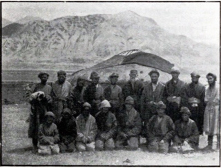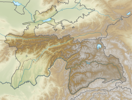
Taxkorgan Tajik Autonomous County is an autonomous county of Kashgar Prefecture in Western Xinjiang,China. The county seat is the town of Tashkurgan. The county is the only Tajik Autonomous County in China.

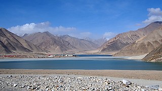
The Kulma Pass or Qolma Pass,also referred to as Karasu Pass,is a mountain pass across the Pamir Mountains on the border between Murghob District,Gorno-Badakhshan Autonomous Region in Tajikistan and Taxkorgan Tajik Autonomous County,Kashgar Prefecture,Xinjiang Uygur Autonomous Region in China. Asian Highway AH66 runs through the pass,which provides for the only modern day overland border crossing along the 450 km boundary between the two nations.

Hotan County is a county in the southwest of the Xinjiang Uyghur Autonomous Region and is under the administration of the Hotan Prefecture. Almost all the residents of the county are Uyghurs and live around oases situated between the desolate Taklamakan Desert and Kunlun Mountains. Hotan County is the southernmost county-level division of Xinjiang. The county borders Karakax/Moyu County to the northwest,Hotan City and Lop County to the northeast,Qira County to the east,Pishan County to the west,and Rutog County,Tibet to the southeast. Hotan County administers most of Aksai Chin,an area disputed between China and India. The Line of Actual Control divides the India-controlled part of Ladakh union territory from the Aksai Chin area administered as part of southwest Hotan County.

Dafdar or Davdar or Daftar or via Mandarin Chinese as Dabuda'er,is a township in the Taghdumbash Pamir located in Tashkurgan Tajik Autonomous County,Kashgar Prefecture,Xinjiang Uyghur Autonomous Region,China. The township is located on the China–Pakistan border. The southern part of the township is located in the Trans-Karakoram Tract claimed by India.
Kokyar is a township headquartered at a small oasis at the base of the Kunlun Mountains in southern Kargilik County,Kashgar Prefecture,southwestern Xinjiang,China.

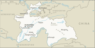
The China–Tajikistan border is 477 km (296 mi) in length and runs from the tripoint with Kyrgyzstan following a roughly north–south line across various mountain ridges and peaks of the Pamir range down to the tripoint with Afghanistan. The border divides Murghob District,Gorno-Badakhshan Autonomous Region in Tajikistan from Akto County,Kizilsu Kyrgyz Autonomous Prefecture and Taxkorgan Tajik Autonomous County,Kashgar Prefecture in Xinjiang Uygur Autonomous Region,China.
Chalachigu Valley or Karachukur Valley is a valley in Taxkorgan Tajik Autonomous County,Kashgar Prefecture,Xinjiang,China. It borders Afghanistan to the west,Tajikistan to the north and Pakistan to the south. It borders Taghdumbash Pamir to the east,Gojal to the south,and Little Pamir to the north and west. The name of the valley is from Kyrgyz meaning "black cave".
The Nezatash Pass or Neza-Tash Pass is a mountain pass in the Sarikol Range between Gorno-Badakhshan Autonomous Province in Tajikistan and Tashkurgan Tajik Autonomous County in Xinjiang,China. It is situated at an elevation of 4,476 metres (14,685 ft). The name of the path means "spear stone" in Kyrgyz as it is named after a rock near the location.

The Muzart Pass,Muz-art Pass,or Muzat Pass is a high mountain pass that crosses the Tian Shan mountains in Xinjiang,China. It connects the city of Aksu in Tarim Basin with the city of Yining (Kulja) in the upper Ili River valley. It is located on the county boundary between Zhaosu County in Ili Prefecture and Baicheng County in Aksu Prefecture. The route over Muzart Pass is more commonly referred to as Xiate Trail by the Chinese,Xiate being the name of the village in Tekes River valley at the base on the northern side of the route.

Tegermansu Pass or Tigarman Su Pass is a closed mountain pass on the border between Afghanistan and China in Wakhan Corridor,in the Hindu Kush —Pamir mountain range. It is located between the Tegermansu Valley on the eastern end of the Little Pamir and Chalachigu Valley in Xinjiang,China. Historically,it was one of the three routes between China and Wakhan.
Boritokay Township is a township of Wuqia County in Kizilsu Kyrgyz Autonomous Prefecture,Xinjiang Uygur Autonomous Region,China. Located in the south of the county,the township covers an area of 4,221 square kilometers (1,630 sq mi) with a population of 6,977. It has 5 villages under its jurisdiction. Its seat is at Dongengiz (墩艾额孜).

Bulungkol Township is a township of Akto County in Xinjiang Uygur Autonomous Region,China. Located in the middle west of the county,the township covers an area of 4,585 square kilometers with a population of 7,133. It has 5 administrative villages under its jurisdiction. Its seat is at Bulungkol Village (布伦口村).
Ujme / Ojma is a township of Akto County in Xinjiang Uygur Autonomous Region,China. Located in the northeast of the county,the township covers an area of 194 square kilometers with a population of 26,107. It has 15 administrative villages under its jurisdiction. Its seat is at Hoylaerik Village (霍伊拉艾日克村).

Koxtag is a town in Pishan/Guma County,Hotan Prefecture,Xinjiang,China.
Muji is a town in Pishan/Guma County,Hotan Prefecture,Xinjiang,China.

Langru is a township in Hotan County,Hotan Prefecture,Xinjiang,China.
Hanerik is a town in Hotan County,Hotan Prefecture,Xinjiang,China.
Toyboldi,also Toy Boldi;or from Mandarin Tuoyi Baoledi is a town in Xayar County,Aksu Prefecture,Xinjiang,China.
Waxxari is a town in Ruoqiang / Qakilik County,Bayingolin Mongol Autonomous Prefecture,Xinjiang,China.


