
Year 756 (DCCLVI) was a leap year starting on Thursday of the Julian calendar, the 756th year of the Common Era (CE) and Anno Domini (AD) designations, the 756th year of the 1st millennium, the 56th year of the 8th century, and the 7th year of the 750s decade. The denomination 756 for this year has been used since the early medieval period, when the Anno Domini calendar era became the prevalent method in Europe for naming years.

Shaanxi is an inland province in Northwestern China. It borders the province-level divisions of Shanxi, Henan (E), Hubei (SE), Chongqing (S), Sichuan (SW), Gansu (W), Ningxia (NW), and Inner Mongolia (N).

Luoyang is a city located in the confluence area of the Luo River and the Yellow River in the west of Henan province. Governed as a prefecture-level city, it borders the provincial capital of Zhengzhou to the east, Pingdingshan to the southeast, Nanyang to the south, Sanmenxia to the west, Jiyuan to the north, and Jiaozuo to the northeast. As of December 31, 2018, Luoyang had a population of 6,888,500 inhabitants with 2,751,400 people living in the built-up area made of the city's five out of six urban districts and Yanshi District, now being conurbated. By the end of 2022, Luoyang Municipality had jurisdiction over 7 municipal districts, 7 counties and 1 development zone. The permanent population is 7.079 million.

The Chu–Han Contention (楚漢相爭), also known as the Chu–Han War (楚漢戰爭), was an interregnum period in Imperial China between the fall of the Qin dynasty and the establishment of the Western Han dynasty. After the third and last Qin ruler, Ziying, unconditionally surrendered to rebel forces in 206 BCE, the former Qin Empire was divided by rebel leader Xiang Yu into the Eighteen Kingdoms, which were ruled by various rebel leaders and surrendered Qin generals. A civil war soon broke out, most prominently between two major contending powers – Xiang Yu's Western Chu and Liu Bang's Han. Some of the other kingdoms also waged war among themselves but these were largely insignificant compared to the main conflict between Chu and Han. The war ended in 202 BCE with a Han victory at the Battle of Gaixia, during which Xiang Yu committed suicide after making a last stand. Liu Bang subsequently proclaimed himself emperor and established the Western Han dynasty.

The Wei River is a major river in west-central China's Gansu and Shaanxi provinces. It is the largest tributary of the Yellow River and very important in the early development of Chinese civilization. In ancient times, such as in the Records of the Grand Historian, the river was called Wei Shui.

Hanzhong is a prefecture-level city in the southwest of Shaanxi province, China, bordering the provinces of Sichuan to the south and Gansu to the west.

Hangu Pass or Hanguguan is a pass separating the upper Yellow River and Wei valleys—the cradle of Chinese civilization and seat of its longtime capital Xi'an—from the fertile North China Plain. It lies on the south bank of the Yellow River just east of its eastward bend out of the Ordos Loop at Tong Pass in Shaanxi. It was the site of many battles during the Warring States and early imperial eras, when it was the chokepoint shielding Qin, Guanzhong, or Luoyang from outside attack. The term Hangu Pass refers to two locations: the Qin dynasty Hangu Pass in Hanguguan Town, Lingbao county, Sanmenxia city, Henan and secondly, the Han dynasty Hangu Pass in Xin’an county, Luoyang city, Henan. In 2014, the archeological site was recognized by UNESCO as part of the “Silk Roads: the Routes Network of Chang'an-Tianshan Corridor” World Heritage Site.

The Feast at Swan Goose Gate, also known as the Banquet at Hongmen, Hongmen Banquet, Hongmen Feast and other similar renditions, was a historical event that took place in 206 BC at Swan Goose Gate outside Xianyang, the capital of the Qin dynasty. Its location in present-day China is roughly at Hongmenbao Village, Xinfeng Town, Lintong District, Xi'an, Shaanxi. The main parties involved in the banquet were Liu Bang and Xiang Yu, two prominent leaders of insurgent forces who rebelled against the Qin dynasty from 209 BC to 206 BC.

The Three Qins refer to three of the Eighteen Kingdoms, the short-lived power-sharing arrangement formed in 206 BC after the collapse of the Qin dynasty. The three kingdoms were located in Guanzhong Plain, the heartland of the Qin Empire.

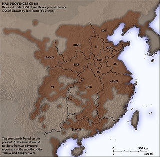
Guanzhong region, also known as the Guanzhong Basin, Wei River Basin, or uncommonly as the Shaanzhong region, is a historical region of China corresponding to the crescentic graben basin within present-day central Shaanxi, bounded between the Qinling Mountains in the south, and the Huanglong Mountain, Meridian Ridge and Long Mountain ranges in the north. The central flatland area of the basin, known as the Guanzhong Plain, is made up of alluvial plains along the lower Wei River and its numerous tributaries and thus also called the Wei River Plain. The region is part of the Jin-Shaan Basin Belt, and is separated from its geological sibling — the Yuncheng Basin to its northeast — by the Yellow River section southwest of the Lüliang Mountains and north of the river's bend at the tri-provincial junction among Shaanxi, Shanxi and Henan.
You Prefecture or YouProvince, also known by its Chinese name Youzhou, was a prefecture (zhou) in northern China during its imperial era.
Hancheng is a city in Shaanxi Province, People's Republic of China, about 125 miles northeast of Xi'an, at the point where the south-flowing Yellow River enters the Guanzhong Plain. It is a renowned historic city, containing numerous historic mansions and streets as well as over 140 protected historical sites that range from the Tang to the Qing dynasties. As of 2005, it has a population of around 385,000 people.

Weinan is a prefecture-level city in the east central Shaanxi province, China. The city lies on the lower section of the Wei River confluence into the Yellow River, about 60 km (37 mi) east of the provincial capital Xi'an, and borders the provinces of Shanxi and Henan to the east.

Tongguan County is a county in the east of Shaanxi province, China, administered as part of the prefecture-level city of Weinan. It is named after the Tong Pass, a historical fortress located south of the confluence of the Wei and Yellow Rivers. It is the southeastern corner of the Ordos Loop, the point at which the Qin Mountains turn the Yellow River sharply eastward, forcing it into the North China Plain, and borders the provinces of Shanxi to the north and Henan to the east.

The Lüliang Mountains are a mountain range in central China, dividing Shanxi's Fen River valley from the Yellow River. The range forces the Yellow River southwards on the eastern side of the Ordos Loop but tapers off to the south, where the Fen turns west to join the Yellow River before the Qin Mountains turn the combined river sharply eastward at its confluence with the Wei at Tongguan in Shaanxi.

Liu Yu's Northern Expeditions were a series of successful campaigns mounted by the Eastern Jin dynasty from 409 AD to 416 AD against the Southern Yan, Later Qin, Northern Wei and Hu Xia dynasties that successfully recovered all of Eastern Jin's territory south of the Yellow River with the exception of the Chang'an area, which was taken by Hu Xia. These victories were the basis of the prosperity of the Reign of Yuanjia.
The Sixteen Kingdoms, less commonly the Sixteen States, was a chaotic period in Chinese history from AD 304 to 439 when northern China fragmented into a series of short-lived dynastic states. The majority of these states were founded by the "Five Barbarians", non-Han peoples who had settled in northern and western China during the preceding centuries, and had launched a series of rebellions against the Western Jin dynasty in the early 4th century. However, several of the states were founded by the Han people, and all of the states—whether ruled by Xiongnu, Xianbei, Di, Jie, Qiang, Han, or others—took on Han-style dynastic names. The states frequently fought against both one another and the Eastern Jin dynasty, which succeeded the Western Jin in 317 and ruled southern China. The period ended with the unification of northern China in 439 by the Northern Wei, a dynasty established by the Xianbei Tuoba clan. This occurred 19 years after the Eastern Jin collapsed in 420, and was replaced by the Liu Song dynasty. Following the unification of the north by Northern Wei, the Northern and Southern dynasties era of Chinese history began.

The Ordos Plateau, also known as the Ordos Basin or simply the Ordos, is a highland sedimentary basin in parts of most Northern China with an elevation of 1,000–1,600 m (3,300–5,200 ft), and consisting mostly of land enclosed by the Ordos Loop, a large northerly rectangular bend of the Yellow River. It is China's second largest sedimentary basin with a total area of 370,000 km2 (140,000 sq mi), and includes territories from five provinces, namely Shaanxi, Gansu, Ningxia, Inner Mongolia and a thin fringe of Shanxi, but is demographically dominated by the former three, hence is also called the Shaan-Gan-Ning Basin. The basin is bounded in the east by the Lüliang Mountains, north by the Yin Mountains, west by the Helan Mountains, and south by the Huanglong Mountains, Meridian Ridge and Liupan Mountains.
The Shudao, or the Road(s) to Shu, is a system of mountain roads linking the Chinese province of Shaanxi with Sichuan (Shu), built and maintained since the 4th century BC. Technical highlights were the gallery roads, consisting of wooden planks erected on wooden or stone beams slotted into holes cut into the sides of cliffs.
 Site of ruins of Tong Pass (Han)
 Old photo
 The Tong Pass in 1941
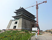 Modern recreation of the fortress' western gate


