
Visakhapatnam (; formerly known as Vizagapatam, also known as Vizag, Viśākha or Waltair is the largest and most populous metropolitan city in the Indian state of Andhra Pradesh. It is between the Eastern Ghats and the coast of the Bay of Bengal. It is the second largest city on the east coast of India after Chennai, and the fourth largest in South India. It is one of the four smart cities of Andhra Pradesh selected under the Smart Cities Mission and is the headquarters of Visakhapatnam district. With an estimated output of $43.5 billion, it is the ninth largest contributor to India's gross domestic product as of 2016. Vizag is popularly knows as shipbuilding capital of India due to presence of multiple shipyard such as Hindustan Shipyard, Naval Dockyard and being the central naval command of the east coast.

Visakhapatnam district is one of the six districts in the Uttarandhra region of the Indian state of Andhra Pradesh, headquartered at Visakhapatnam. It is one of the twenty-six districts in Andhra Pradesh state. The district shares borders within the north and east, Vizianagaram district and South Anakapalli district in the south-west and Bay of Bengal in the south.

Anakapalli is a residential neighborhood in the city of Visakhapatnam, also the headquarters of Anakapalli district of Andhra Pradesh. In 2015 Anakapalli municipality was merged with the Greater Visakhapatnam Municipal Corporation. It falls under zone 7 of GVMC. It contains India's second largest jaggery market.

The Gosthani river is a river in India. It rises in the Ananthagiri Hills of the Eastern Ghats and flows through the Borra Caves which lie near its source. It is the largest river flowing through Visakhapatnam city. It flows for 120 km before joining the Bay of Bengal through an estuary near Bheemunipatnam. The river basin drains the two coastal districts of Vizianagaram and Visakhapatnam. The basin exhibits a subdendritic and dendritic pattern of drainage. The Gosthani's is a minor river basin with a total drainage area of less than 2000 km2. Much of the basin is covered by khondalite group of gneissic rocks. About 3% of the total area of the Visakhapatnam district is under the Gosthani basin. The river is rainfed, receiving an average rainfall of 110 cm most of which comes from the south-west monsoon. There are several red sand hills near Bheemunipatnam, where the Gosthani joins the Bay of Bengal, which are reminiscent of the Chambal ravines. These are thought to have been formed six millennia ago due to shifts in the river's course following tectonic activity. The river joins the Bay of Bengal at Bhimli where it forms an estuary.

Pendurthi is a neighbourhood in the city of Visakhapatnam, India. The neighbourhood is considered as the major residential and commercial area in the city. It is located within the jurisdiction of the Greater Visakhapatnam Municipal Corporation, which is responsible for the civic amenities in Pendurthi. It is located on the west fringe of Visakhapatnam city. Pendurthi is one of the peaceful neighborhoods of Western Vizag. The pincode of Pendurthi is 531173.

North Andhra or Uttara Andhra, also known as Kalinga Andhra, is a geographic region in the Indian state of Andhra Pradesh. It is between the Eastern Ghats and the coast of the Bay of Bengal. It comprises six northern districts of the state, Srikakulam, Parvathipuram Manyam, Vizianagaram, Visakhapatnam, half of the Alluri Sitharama Raju district and Anakapalli. Alluri Sitharama Raju district was carved out of Erstwhile Visakhapatnam and East Godavari districts. So, half of the Alluri Sitharamaraju district belongs to North Andhra/ Uttara Andhra and the southern part of this district belongs to Coastal Andhra region/ Godavari region. As of 2011 census of India, the region with six districts has a population of 9,338,177.

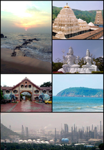
Andhra Pradesh is a state in India. Andhra Pradesh Tourism Development Corporation (APTDC) is a state government agency which promotes tourism in Andhra Pradesh, describing the state as the Koh-i-Noor of India. Andhra Pradesh has a variety of tourist attractions including beaches, hills, caves, wildlife, forests and temples.

Thotlakonda Buddhist Complex is situated on a hill near Bheemunipatnam about 15 kilometres (9.3 mi) from Visakhapatnam in Andhra Pradesh, India. The hill is about 128 metres (420 ft) above sea level and overlooks the sea. The Telugu name Toṭlakoṇḍa derived from the presence of a number of rock-cut cisterns hewn into the bedrock of the hillock. In 2019, the stupa was partially damaged due to monsoons, but it was restored by 2021 at the cost of Rs 42 lakh.

Madhurawada is a major business and residential area of Visakhapatnam in the state of Andhra Pradesh. It is located on the Visakhapatnam-Vizianagaram stretch of National Highway 16 around 16 km from the city center of Visakhapatnam.
Pavurallakonda or Pavurallabodu is a hill popularly known as Narasimhaswamy Konda. It is located near Bheemunipatnam, about 25 km north of Visakhapatnam, Andhra Pradesh, India.

The Khurda Road–Visakhapatnam section is a railway line connecting Khurda Road in the Indian state of Odisha and Visakhapatnam in Andhra Pradesh. The main line is part of the Howrah–Chennai main line.

Gudiwada Dibba is a small hillock at Gudiwada village in Bhogapuram mandal, Vizianagaram district, Andhra Pradesh. It located on the banks of River Gosthani.
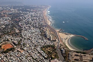
Visakhapatnam is the largest city of Andhra Pradesh. Visakhapatnam has a GDP of $43.5 billion. It is the 9th richest city in India. Fishing industry, road–rail connectivity, many heavy industries like Hindustan Petroleum, Visakhapatnam Steel Plant, Hindustan Shipyard, Visakhapatnam Port Trust, National Thermal Power, Bharat Heavy Electricals, BARC, Naval Science and Technological Laboratory, Naval Dockyard, Dredging Corporation of India, Strategic Petroleum Reserve, NMDC, CONCOR, Andhra Pradesh Medtech Zone etc..

Bheemili Beach is located at the origin of the Gosthani River, at a distance of 24 km from Visakhapatnam in Visakhapatnam district of the Indian state of Andhra Pradesh. The beach reflects the British and Dutch settlements of the 17th century.

The coastline of Andhra Pradesh is located on the southeastern coast of the Indian Peninsula in the Bay of Bengal and is part of the Northern Circars. With a length of 975 km, it has the second longest coastline in India after Gujarat. The coastal corridor boasts several ports, harbors, vast stretches of sandy beaches, wildlife and bird sanctuaries, as well as fresh water lakes and estuaries.

Greater Visakhapatnam Municipal Corporation (GVMC) is the civic body that governs the city of Visakhapatnam, largest city of the Indian state of Andhra Pradesh. Its jurisdiction encompasses an area of 640 km2 (250 sq mi). It is also part of the planning body of the Visakhapatnam Metropolitan Region Development Authority. Established in the year 1979, the executive power of the GVMC is vested in the Municipal Commissioner, an Indian Administrative Service officer appointed by the Government of Andhra Pradesh. The position is held by Saikanth Varma. Golagani Hari Venkata Kumari (YSRCP) was elected as the Mayor and Jiyyani Sridhar (YSRCP) as the Deputy Mayor by the newly elected general body in March 2021. In January 2021, the number of wards were increased to 98 from 81 earlier.
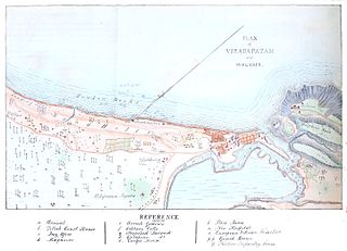
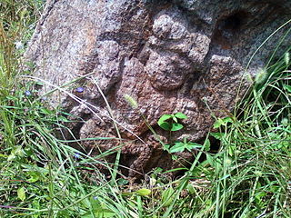
Visakhapatnam is a major metropolitan city in the state of Andhra Pradesh, and it holds the distinction of being the largest city in the state. The rich history of Visakhapatnam dates back over 2,500 years, with its present name potentially given by the Eastern Chalukyas king to their family deity Visakha in 1010 CE. Visakhapatnam was once part of the Kalinga Kingdom around 260 BC before coming under the influence of the Maurya Empire. During this period, Buddhism flourished, leading to the construction of significant monuments between the 2nd century BCE and the 2nd century CE. The city's documented existence begins in 1068 CE, under the rule of King Vishakhavarman. In the 7th century, Visakhapatnam witnessed the conquest of the Eastern Chalukyas, and by the 14th century, it became part of the Reddi Kingdom. The era of European colonization commenced in 1630 with the Dutch, followed by the British taking control in 1757 after a brief interlude of French influence. The Battle of Vizagapatam in 1804 during the Napoleonic Wars emphasized the strategic importance of the city. Following India's independence in 1947, Visakhapatnam became part of the Madras Presidency, later becoming an integral part of Andhra Pradesh. Today, it stands as the largest city in Andhra Pradesh, playing a pivotal role in the state's economy. The city's industrial growth saw a transformative phase with the inauguration of Visakhapatnam Port operations on December 19, 1933, firmly establishing it as a major industrial centre.
Transport in Visakhapatnam is the network of roads, railways, rapid transit system in the largest city of Andhra Pradesh. The city of Visakhapatnam also serves as the central hub of transport and logistics on the East coast of India and hence it is called as City Of Destiny.

There are various modes of transportation available in Vizianagaram and its Neighbourhoods. It includes auto rickshaws, bicycles to mass transit systems - such as buses, trains and flights.

The Administration of Visakhapatnam officially started in 1803, with the municipality of Visakhapatnam being established in 1861. Currently, it is known as the Greater Visakhapatnam Municipal Corporation (GVMC). Its total area is 681 km2 (263 sq mi) with 98 wards and 8 zones. The mayor is elected by corporators who are representative of their wards.


