Related Research Articles

A dune is a landform composed of wind- or water-driven sand. It typically takes the form of a mound, ridge, or hill. An area with dunes is called a dune system or a dune complex. A large dune complex is called a dune field, while broad, flat regions covered with wind-swept sand or dunes, with little or no vegetation, are called ergs or sand seas. Dunes occur in different shapes and sizes, but most kinds of dunes are longer on the stoss (upflow) side, where the sand is pushed up the dune, and have a shorter slip face in the lee side. The valley or trough between dunes is called a dune slack.
The Physics of Blown Sand and Desert Dunes is a scientific book written by Ralph A. Bagnold. The book laid the foundations of the scientific investigation of the transport of sand by wind. It also discusses the formation and movement of sand dunes in the Libyan Desert. During his expeditions into the Libyan Desert, Bagnold had been fascinated by the shapes of the sand dunes, and after returning to England he built a wind tunnel and conducted the experiments which are the basis of the book.

A ventifact is a rock that has been abraded, pitted, etched, grooved, or polished by wind-driven sand or ice crystals. These geomorphic features are most typically found in arid environments where there is little vegetation to interfere with aeolian particle transport, where there are frequently strong winds, and where there is a steady but not overwhelming supply of sand.

A barchan or barkhan dune is a crescent-shaped dune. The term was introduced in 1881 by Russian naturalist Alexander von Middendorf, based on their occurrence in Turkestan and other inland desert regions. Barchans face the wind, appearing convex and are produced by wind action predominantly from one direction. They are a very common landform in sandy deserts all over the world and are arc-shaped, markedly asymmetrical in cross section, with a gentle slope facing toward the wind sand ridge, comprising well-sorted sand.

Aeolian processes, also spelled eolian, pertain to wind activity in the study of geology and weather and specifically to the wind's ability to shape the surface of the Earth. Winds may erode, transport, and deposit materials and are effective agents in regions with sparse vegetation, a lack of soil moisture and a large supply of unconsolidated sediments. Although water is a much more powerful eroding force than wind, aeolian processes are important in arid environments such as deserts.

A ridge is a long, narrow, elevated geomorphologic landform, structural feature, or a combination of both separated from the surrounding terrain by steep sides. The sides of a ridge slope away from a narrow top, the crest or ridgecrest, with the terrain dropping down on either side. The crest, if narrow, is also called a ridgeline. Limitations on the dimensions of a ridge are lacking. Its height above the surrounding terrain can vary from less than a meter to hundreds of meters. A ridge can be either depositional, erosional, tectonic, or a combination of these in origin and can consist of either bedrock, loose sediment, lava, or ice depending on its origin. A ridge can occur as either an isolated, independent feature or part of a larger geomorphological and/or structural feature. Frequently, a ridge can be further subdivided into smaller geomorphic or structural elements.
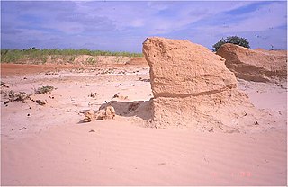
A yardang is a streamlined protuberance carved from bedrock or any consolidated or semiconsolidated material by the dual action of wind abrasion by dust and sand and deflation. Yardangs become elongated features typically three or more times longer than wide, and when viewed from above, resemble the hull of a boat. Facing the wind is a steep, blunt face that gradually gets lower and narrower toward the lee end. Yardangs are formed by wind erosion, typically of an originally flat surface formed from areas of harder and softer material. The soft material is eroded and removed by the wind, and the harder material remains. The resulting pattern of yardangs is therefore a combination of the original rock distribution, and the fluid mechanics of the air flow and resulting pattern of erosion.

Blowouts are sandy depressions in a sand dune ecosystem (psammosere) caused by the removal of sediments by wind.

A Dreikanter is a type of ventifact that typically forms in desert or periglacial environments due to the abrasive action of blowing sand.

In geology, saltation is a specific type of particle transport by fluids such as wind or water. It occurs when loose materials are removed from a bed and carried by the fluid, before being transported back to the surface. Examples include pebble transport by rivers, sand drift over desert surfaces, soil blowing over fields, and snow drift over smooth surfaces such as those in the Arctic or Canadian Prairies.

An erg is a broad, flat area of desert covered with wind-swept sand with little or no vegetative cover. The word is derived from the Arabic word ʿarq (عرق), meaning "dune field". Strictly speaking, an erg is defined as a desert area that contains more than 125 km2 (48 sq mi) of aeolian or wind-blown sand and where sand covers more than 20% of the surface. Smaller areas are known as "dune fields". The largest hot desert in the world, the Sahara, covers 9 million square kilometres and contains several ergs, such as the Chech Erg and the Issaouane Erg in Algeria. Approximately 85% of all the Earth's mobile sand is found in ergs that are greater than 32,000 km2 (12,355 sq mi), the largest being the Rub' al Khali, the Empty Quarter of the Arabian Peninsula. Ergs are also found on other celestial bodies, such as Venus, Mars, and Saturn's moon Titan.

Olympia Undae is a vast dune field in the north polar region of the planet Mars. It consists of a broad "sand sea" or erg that partly rings the north polar plateau from about 120° to 240°E longitude and 78° to 83°N latitude. Stretching about 1,100 km (680 mi) across and covering an area of 470,000 km2, Olympia Undae is the largest continuous dune field on Mars. It is similar in size to the Rub' Al Khali in the Arabian Peninsula, the largest active erg on Earth.
Aeolian landforms are features produced by either the erosive or depositive action of the wind. These features may be built up from sand or snow, or eroded into rock, snow, or ice. Aeolian landforms are commonly observed in sandy deserts and on frozen lakes or sea ice and have been observed and studied across Earth and on other planets, including Mars and Pluto

Paha are elongated landforms composed either of only loess or till capped by loess. In Iowa, paha are prominent hills that are oriented from northwest to southeast, formed during the period of mass erosion that developed the Iowan surface, and they are considered erosional remnants since they often preserve buried soils. Paha generally rise above the surrounding landscape more than 6.1 metres (20 ft). The word paha means hill in Dakota Sioux. Well known pahas include the hill on which the town of Mount Vernon, Iowa developed, Casey's Paha in Tama County, Iowa, and the Kirkwood Paha, home of Kirkwood Community College's campus. These features are found in other regions of the United States and in Europe, where they are known as greda.

Oliver Lanard Fassig was an American meteorologist and climatologist who worked for the United States Weather Bureau initially as part of the Signal Corps of the United States War Department and later affiliated with the United States Department of Agriculture.
Andrew Warren is a British physical geographer. He is Emeritus Professor of Geography at University College London, UK.
Transverse aeolian ridges (TARs) are visually bright features commonly found in topographic depressions on Mars. These small-scale and relict bedforms were first seen in narrow-angle images from the Mars Orbiter Camera (MOC) and were called “ridges” to preserve both dunes and ripples as formative mechanisms. While TARs are widespread on Mars, their formation, age, composition, and role in past Martian sediment cycles remain poorly constrained.

Tropical deserts are located in regions between 15 and 30 degrees latitude. The environment is very extreme, and they have the highest average monthly temperature on Earth. Rainfall is sporadic; precipitation may not be observed at all in a few years. In addition to these extreme environmental and climate conditions, most tropical deserts are covered with sand and rocks, and thus too flat and lacking in vegetation to block out the wind. Wind may erode and transport sand, rocks and other materials; these are known as eolian processes. Landforms caused by wind erosion vary greatly in characteristics and size. Representative landforms include depressions and pans, Yardangs, inverted topography and ventifacts. No significant populations can survive in tropical deserts due to extreme aridity, heat and the paucity of vegetation; only specific flora and fauna with special behavioral and physical mechanisms are supported. Although tropical deserts are considered to be harsh and barren, they are in fact important sources of natural resources and play a significant role in economic development. Besides the equatorial deserts, there are many hot deserts situated in the tropical zone.

Stephen Conrad Stuntz (1875–1918) was an American botanist and fiction author.

The Chinese Loess Plateau, or simply the Loess Plateau, is a plateau in north-central China formed of loess, a clastic silt-like sediment formed by the accumulation of wind-blown dust. It is located southeast of the Gobi Desert and is surrounded by the Yellow River. It includes parts of the Chinese provinces of Gansu, Shaanxi and Shanxi. The depositional setting of the Chinese Loess Plateau was shaped by the tectonic movement in the Neogene period, after which strong southeast winds caused by the East Asian Monsoon transported sediment to the plateau during the Quaternary period. The three main morphological types in the Loess Plateau are loess platforms, ridges and hills, formed by the deposition and erosion of loess. Most of the loess comes from the Gobi Desert and other nearby deserts. The sediments were transported to the Loess Plateau during interglacial periods by southeasterly prevailing winds and winter monsoon winds. After the deposition of sediments on the plateau, they were gradually compacted to form loess under the arid climate.
References
- 1 2 3 Warren, A.; Gill, T.E.; Stout, J.E. (2020), Bibliography of Aeolian Research, vol. 1, USDA-Agricultural Research Service, Lubbock, Texas, doi:10.17632/675gwk5jp7.1 , retrieved 2014-07-19
- ↑ Stout, J.E.; Warren, A.; Gill, T.E. (2009), "Publication trends in aeolian research: an analysis of the Bibliography of Aeolian Research", Geomorphology, 105 (1–2): 6–17, Bibcode:2009Geomo.105....6S, doi:10.1016/j.geomorph.2008.02.015
- ↑ Fassig, O.L. (1889), Bibliography of Meteorology, United States of America War Department, Signal Office, Washington DC, p. 475
- ↑ Stuntz, S.C.; Free, E.E. (1911), Bibliography of Eolian Geology. In: Free, E.E. (ed), The movement of soil material by wind, vol. Bulletin 68, United States Department of Agriculture, Bureau of Soils, Washington DC, pp. 174–263
- ↑ Warren, A. (1969), A Bibliography of Desert Dunes and Associated Phenomena. In: McGinnies, W.G. and Goldman, B.J. (eds), Arid Lands in Perspective, American Association for the Advancement of Science, Washington D.C. and Tucson: University of Arizona Press, pp. 75–100
- ↑ Dust Storm News , retrieved 2024-01-21