Mount Rainier National Park is an American national park located in southeast Pierce County and northeast Lewis County in Washington state. The park was established on March 2, 1899, as the fourth national park in the United States, preserving 236,381 acres including all of Mount Rainier, a 14,410-foot (4,390 m) stratovolcano. The mountain rises abruptly from the surrounding land with elevations in the park ranging from 1,600 feet to over 14,000 feet (490–4,300 m). The highest point in the Cascade Range, Mount Rainier is surrounded by valleys, waterfalls, subalpine meadows, and 91,000 acres of old-growth forest. More than 25 glaciers descend the flanks of the volcano, which is often shrouded in clouds that dump enormous amounts of rain and snow.

The Wonderland Trail is an approximately 93-mile (150 km) hiking trail that circumnavigates Mount Rainier in Mount Rainier National Park, Washington, United States. The trail goes over many ridges of Mount Rainier for a cumulative 22,000 feet (6,700 m) of elevation gain. The trail was built in 1915. In 1981, it was designated a National Recreation Trail. An estimated 200 to 250 people a year complete the entire trail with several thousand others doing shorter sections of it. The average time taken to complete the entire trip is 10 to 14 days.

Mount Adams, known by some Native American tribes as Pahto or Klickitat, is a potentially active stratovolcano in the Cascade Range. Although Adams has not erupted in more than 1,000 years, it is not considered extinct. It is the second-highest mountain in Washington, after Mount Rainier.
The Mountaineers is an alpine club in the US state of Washington. Founded in 1906, it is organized as an outdoor recreation, education, and conservation 501(c)(3) nonprofit organisation, and is based in Seattle, Washington. The club hosts a wide range of outdoor activities, primarily alpine mountain climbing and hikes. The club also hosts classes, training courses, and social events.

The Mazamas is a mountaineering organization based in Portland, Oregon, United States, founded in 1894.

The Nisqually Glacier is one of the larger glaciers on the southwestern face of Mount Rainier in the U.S. state of Washington. The glacier is one of the most easily viewed on the mountain, and is accessible from the Paradise visitor facilities in Mount Rainier National Park. The glacier has had periods of advance and retreat since 1850 when it was much more extensive. It is currently retreating. Measurements made at 9,200 feet (2,800 m) altitude show that glacier got 56 ft (17 m) thicker between 1994 and 1997, suggesting that it will probably begin advancing in the first decade of the 21st century. Nisqually Glacier is the source of the Nisqually River.
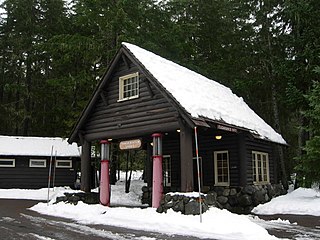
Longmire, which is effectively encompassed by the Longmire Historic District, is a visitor services center in Washington State's Mount Rainier National Park, located 6.5 miles (10.5 km) east of the Nisqually Entrance. The area is in the Nisqually River valley at an elevation of 2,761 feet (842 m) between The Ramparts Ridge and the Tatoosh Range. Longmire is surrounded by old-growth Douglas fir, western red cedar and western hemlock.

Philemon Beecher Van Trump was an American pioneering mountaineer and writer who lived in the state of Washington. He is best known for the first documented ascent of Mount Rainier in 1870.

Carbon Glacier is located on the north slope of Mount Rainier in the U.S. state of Washington and is the source of the Carbon River. The snout at the glacier terminal moraine is at about 3,500 feet (1,100 m) above sea level, making it the lowest-elevation glacier in the contiguous United States. The glacier also has the greatest length, thickness and volume of any U.S. glacier outside of Alaska.

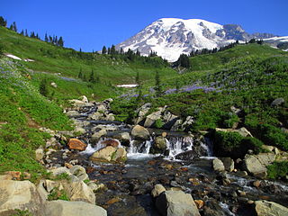
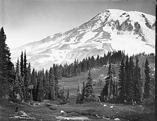
Paradise is the name of an area at approximately 5,400 feet (1,600 m) on the south slope of Mount Rainier in Mount Rainier National Park in Washington, United States. Southeast of Seattle, the area lies on the border of Pierce and Lewis counties and includes the Paradise Valley and the Paradise Glacier, the source of the Paradise River. Virinda Longmire named Paradise in the summer of 1885 while she viewed the wildflowers in the alpine meadows there. Paradise also offers views of Mount Rainier and the Tatoosh Range.

Mount Rainier, also known as Tahoma, is a large active stratovolcano in the Cascade Range of the Pacific Northwest in the United States. The mountain is located in Mount Rainier National Park about 59 miles (95 km) south-southeast of Seattle. With a summit elevation of 14,411 ft (4,392 m), it is the highest mountain in the U.S. state of Washington, the most topographically prominent mountain in the contiguous United States, and the tallest in the Cascade Volcanic Arc.
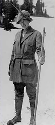
Alma Wagen was an American mountain guide on Mount Rainier. She was the first female guide employed by Mount Rainier National Park.

Burroughs Mountain is a mountain in Pierce County, Washington, United States.
Eagle Peak is a 5,958-foot (1,816-metre) mountain summit in Lewis County of Washington state. It is set on the west end of the Tatoosh Range which is a sub-range of the Cascade Range. It is located south of Mount Rainier, within Mount Rainier National Park, and immediately east of Longmire. Eagle Peak was originally known as Simlayshe, a Native American word meaning eagle. George Longmire anglicized the name to Eagle Peak. The four-mile Eagle Peak Trail leads to views of Mount Rainier. The summit of Eagle Peak requires scrambling. Precipitation runoff on the peak drains into the Nisqually River.
Dege Peak is a 7,006-foot summit located in Pierce County of Washington state. It is part of the Sourdough Mountains in Mount Rainier National Park. It was named in 1932 for James Henry Dege, a prominent Tacoma businessman and Captain of the First Regiment National Guard of Washington. His mother was a descendant of President Zachary Taylor.

Mount Fremont is a 7,214-foot-elevation mountain summit located in Mount Rainier National Park in Pierce County of Washington state. Mount Fremont is a minor peak at the southwest corner of the Sourdough Mountains which are a subset of the Cascade Range. It also the juncture for a small ridge of peaks of similar size running to the northeast. Mount Fremont is situated northwest of the Sunrise Historic District, with a popular trail leading to the Mount Fremont Fire Lookout. However, this trail does not reach the true summit which is 0.25 mi (0.40 km) north of Frozen Lake. Peak 7317, also known as Mount Fremont North, located 0.31 mi (0.50 km) west-northwest along the ridge is its nearest higher neighbor. Access is limited by snowpack closing the Sunrise Road much of the year. July, August, and September are typically the months when the Sunrise Road is seasonally open for vehicle traffic. Precipitation runoff from Mount Fremont drains into the White River.

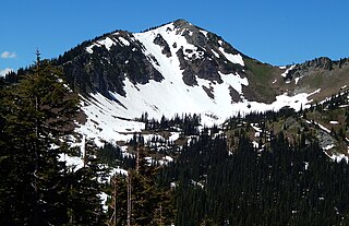
Old Desolate is a 7,137-foot (2,175 m) multi-summit, ridge-like mountain located in Mount Rainier National Park, in Pierce County of Washington state. It is part of the Cascade Range, and lies five miles (8.0 km) due north of the summit of Mount Rainier. The Wonderland Trail provides an approach to this mountain, and the summit offers views of Sluiskin Mountain and Mount Rainier. Burroughs Mountain is the nearest higher neighbor, 2.37 mi (3.81 km) to the southeast. Precipitation runoff from Old Desolate drains east into the West Fork White River, or west into the Carbon River.

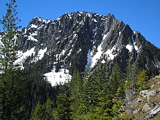
Goat Island Mountain is a 7,288-foot (2,221 m) ridge-like mountain located in Mount Rainier National Park, in Pierce County of Washington state. It is part of the Cascade Range, and lies 5.76 mi (9.27 km) east-northeast of the summit of Mount Rainier. This mountain is quite visible from the Sunrise Historic District and the many trails surrounding the Sunrise area. The Wonderland Trail provides an approach to this mountain, and the summit offers views of Cowlitz Chimneys, Fryingpan Glacier, and Mount Rainier. Burroughs Mountain is its nearest higher neighbor, 2.51 mi (4.04 km) to the northwest. Precipitation runoff from Goat Island Mountain drains into the White River. The mountain's descriptive name derives from mountain goats that were often seen on the peak. The toponym was officially adopted in 1932 by the United States Board on Geographic Names.
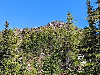
Mineral Mountain is a 6,503 feet (1,982 m) mountain in Mount Rainier National Park, in Pierce County of Washington state. It is part of the Cascade Range, and lies 5 mi (8.0 km) due north of the summit of Mount Rainier. The Wonderland Trail provides an approach to this mountain, and the summit offers views of Old Desolate and the Winthrop and Carbon glaciers on Mount Rainier. Old Desolate is its nearest higher neighbor, 1.16 mi (1.87 km) to the southeast.
Mount Rainier is a stratovolcano within the Cascade Range of the Pacific Northwest. The mountain is within modern-day Washington state, 59 miles south south-east of Seattle. Mt. Rainier is the tallest mountain in the Cascade Range, the fifth tallest in the contiguous 48, and the most prominent peak in the contiguous 48. The peak can be seen from approximately 150 miles away. It is classified as an active volcano with the last eruptions occurring between 1894 and 1895. Mt. Rainier has a height of 14,410 ft and a prominence of 13,246 ft.
