Eastern Washington

Last updated

Eastern Washington
Geographic region
Nickname: 
Eastside
Eastern Washington map.svg
Country United States
State Washington
Area
  Total46,620 sq mi (120,700 km2)
Highest elevation12,276 ft (3,742 m)
Lowest elevation79 ft (24 m)
Population
 (2019)
1,641,900

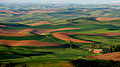
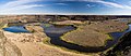
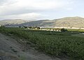
Eastern Washington is the region of the U.S. state of Washington located east of the Cascade Range. It contains the city of Spokane (the second largest city in the state), the Tri-Cities, the Columbia River and the Grand Coulee Dam, the Hanford Nuclear Reservation and the fertile farmlands of the Yakima Valley and the Palouse. Unlike in Western Washington, the climate is dry, including some desert environments.

Contents

Climate

Koppen climate types in eastern Washington Eastern Washington Koppen.png
Köppen climate types in eastern Washington

A significant difference between Eastern Washington and the western half of the state is its climate. While the west half of the state is located in a rainy oceanic climate, the eastern half receives little rainfall due to the rainshadow created by the Cascade Mountains. Also, due to being farther from the sea, the east side has both hotter summers and colder winters than the west. Most communities in Eastern Washington, for example, have significant yearly snowfall, while in the west snowfall is minimal and not seen every year. The east and west do still have some climatic traits in common, though: more rainfall in winter than summer, a lack of severe storms, and milder temperature ranges than more inland locations.

There is some variation in both temperature and rainfall throughout Eastern Washington. Generally, lower elevations are both hotter and drier than higher elevations. This is easily seen in the comparison between low-elevation Richland with higher elevation Spokane.

Climate data for Tri-Cities, Washington (combined average of 3 cities)
MonthJanFebMarAprMayJunJulAugSepOctNovDecYear
Record high °F (°C)74
(23)
74
(23)
87
(31)
95
(35)
105
(41)
111
(44)
115
(46)
115
(46)
106
(41)
89
(32)
79
(26)
71
(22)
115
(46)
Mean maximum °F (°C)58.3
(14.6)
62.6
(17.0)
72.7
(22.6)
83.4
(28.6)
93.0
(33.9)
99.7
(37.6)
105.7
(40.9)
102.7
(39.3)
93.8
(34.3)
80.8
(27.1)
68.3
(20.2)
59.6
(15.3)
106.4
(41.3)
Average high °F (°C)41.1
(5.1)
48.8
(9.3)
58.5
(14.7)
66.5
(19.2)
75.2
(24.0)
82.4
(28.0)
91.0
(32.8)
89.7
(32.1)
80.3
(26.8)
66.4
(19.1)
50.5
(10.3)
41.2
(5.1)
66.1
(18.9)
Average low °F (°C)27.7
(−2.4)
30.2
(−1.0)
35.1
(1.7)
40.0
(4.4)
47.8
(8.8)
54.4
(12.4)
59.4
(15.2)
58.4
(14.7)
49.9
(9.9)
40.6
(4.8)
33.6
(0.9)
28.1
(−2.2)
42.2
(5.7)
Mean minimum °F (°C)8.5
(−13.1)
14.4
(−9.8)
21.5
(−5.8)
25.7
(−3.5)
32.2
(0.1)
41.8
(5.4)
47.0
(8.3)
45.5
(7.5)
35.2
(1.8)
24.0
(−4.4)
16.6
(−8.6)
9.3
(−12.6)
3.4
(−15.9)
Record low °F (°C)−27
(−33)
−23
(−31)
10
(−12)
18
(−8)
26
(−3)
35
(2)
38
(3)
37
(3)
21
(−6)
9
(−13)
−12
(−24)
−22
(−30)
−27
(−33)
Average precipitation inches (mm)1.00
(25)
0.66
(17)
0.63
(16)
0.48
(12)
0.63
(16)
0.57
(14)
0.17
(4.3)
0.22
(5.6)
0.31
(7.9)
0.56
(14)
0.90
(23)
1.08
(27)
7.24
(184)
Average snowfall inches (cm)3.2
(8.1)
1.6
(4.1)
0.2
(0.51)
trace0.0
(0.0)
0.0
(0.0)
0.0
(0.0)
0.0
(0.0)
0.0
(0.0)
trace1.5
(3.8)
2.2
(5.6)
8.5
(22)
Source 1: WRCC [1] [2]
Source 2: NOAA [3]
Climate data for Spokane (combined average of 3 stations)
MonthJanFebMarAprMayJunJulAugSepOctNovDecYear
Record high °F (°C)62
(17)
64
(18)
75
(24)
90
(32)
97
(36)
108
(42)
112
(44)
112
(44)
102
(39)
87
(31)
70
(21)
63
(17)
112
(44)
Mean maximum °F (°C)51.5
(10.8)
54.3
(12.4)
64.9
(18.3)
76.2
(24.6)
86.6
(30.3)
93.5
(34.2)
100.3
(37.9)
99.2
(37.3)
90.6
(32.6)
76.6
(24.8)
59.6
(15.3)
51.6
(10.9)
101.9
(38.8)
Average high °F (°C)35.3
(1.8)
41.5
(5.3)
49.8
(9.9)
58.5
(14.7)
67.9
(19.9)
75.3
(24.1)
85.4
(29.7)
84.3
(29.1)
74.3
(23.5)
59.5
(15.3)
43.5
(6.4)
35.3
(1.8)
59.2
(15.1)
Average low °F (°C)24.9
(−3.9)
27.5
(−2.5)
31.5
(−0.3)
36.6
(2.6)
43.8
(6.6)
50.6
(10.3)
56.2
(13.4)
55.1
(12.8)
47.1
(8.4)
37.8
(3.2)
30.6
(−0.8)
25.1
(−3.8)
38.9
(3.8)
Mean minimum °F (°C)0.7
(−17.4)
7.0
(−13.9)
17.8
(−7.9)
26.8
(−2.9)
32.0
(0.0)
40.2
(4.6)
45.5
(7.5)
44.2
(6.8)
34.5
(1.4)
25.3
(−3.7)
15.1
(−9.4)
5.82
(−14.54)
−6.4
(−21.3)
Record low °F (°C)−30
(−34)
−24
(−31)
−10
(−23)
14
(−10)
24
(−4)
33
(1)
37
(3)
30
(−1)
22
(−6)
7
(−14)
−13
(−25)
−25
(−32)
−30
(−34)
Average precipitation inches (mm)1.98
(50)
1.37
(35)
1.69
(43)
1.25
(32)
1.55
(39)
1.41
(36)
0.53
(13)
0.63
(16)
0.71
(18)
1.14
(29)
2.13
(54)
2.40
(61)
16.81
(427)
Average snowfall inches (cm)9.9
(25)
4.1
(10)
1.8
(4.6)
0.5
(1.3)
tracetracetrace0.0
(0.0)
trace0.1
(0.25)
4.2
(11)
12.7
(32)
33.2
(84)
Source 1: WRCC [4] [5]
Source 2: NOAA [6]

Geography

Nomenclature

Other terms used for Eastern Washington or large parts of it include:

Cities

Spokane is the largest city in eastern Washington and the metropolitan center of the Inland Empire region SpokaneFromPalisades 20070614.jpg
Spokane is the largest city in eastern Washington and the metropolitan center of the Inland Empire region

The following cities and towns in Eastern Washington have over 10,000 inhabitants. [10]

Protected areas

The summit of Goat Peak in the Okanogan-Wenatchee National Forest Goat Peak, Cascades.jpg
The summit of Goat Peak in the Okanogan–Wenatchee National Forest

Counties

Eastern Washington is composed of Adams, Asotin, Benton, Chelan, Columbia, Douglas, Ferry, Franklin, Garfield, Grant, Kittitas, Klickitat, Lincoln, Okanogan, Pend Oreille, Spokane, Stevens, Walla Walla, Whitman, and Yakima counties. Some definitions also include part of Skamania County that lies east of the ridge line of the Cascade Mountains. [11]

Population

Compared to Western Washington, Eastern Washington has roughly twice the land area and one-fifth the population. According to the U.S. Census Bureau the population estimate as of July 2019 was 1,641,900. The population growth rate between the two is roughly the same. Of Washington's ten Congressional districts, Eastern Washington exactly encompasses two (the 4th and 5th), aside from a small portion of the 3rd in Skamania County.

Education

Bryan Hall, Washington State University Bryan Hall.jpg
Bryan Hall, Washington State University

Eastern Washington hosts a number of universities including three of the state's five public universities.

Public institutions

Private institutions

Research institutions

Proposed statehood

Proposed State of Liberty in Eastern Washington
.mw-parser-output .legend{page-break-inside:avoid;break-inside:avoid-column}.mw-parser-output .legend-color{display:inline-block;min-width:1.25em;height:1.25em;line-height:1.25;margin:1px 0;text-align:center;border:1px solid black;background-color:transparent;color:black}.mw-parser-output .legend-text{}
Washington
Liberty Map of Liberty.svg
Proposed State of Liberty in Eastern Washington
  Washington
  Liberty

There have been sporadic movements to create a 51st state out of Eastern Washington by splitting the current state down the Cascades, but proposals have rarely progressed out of the state legislature's committees. Bills in the Washington State Legislature which would have requested the United States Congress to take up the question were proposed in 1996, 1999, 2005, and 2017. [12] Proposed names for the new state have included Lincoln, Columbia, Liberty, [13] or simply Eastern Washington. Many of these proposals would include the Idaho Panhandle as part of the proposed state of Lincoln.

Eastern Washington tends to vote Republican, whereas Western Washington usually votes Democratic. However, Spokane, the proposed capital and largest city, tends to have a higher democratic vote than other Eastern Washington cities. Additionally, Whitman County votes Democratic.

Images

Related Research Articles

<span class="mw-page-title-main">Yakima River</span> River in Washington state, United States

The Yakima River is a tributary of the Columbia River in south central and eastern Washington state, named for the indigenous Yakama people. Lewis and Clark mention in their journals that the Chin-nâm pam called the river Tâpe têtt, possibly from the French tape-tête, meaning "head hit". The length of the river from headwaters to mouth is 214 miles (344 km), with an average drop of 9.85 feet per mile (1.866 m/km). It is the longest river entirely in Washington state.

<span class="mw-page-title-main">Benton County, Washington</span> County in Washington, United States

Benton County is a county in the south-central portion of the U.S. state of Washington. As of the 2020 census, its population was 206,873. The county seat is Prosser, and its largest city is Kennewick. The Columbia River demarcates the county's north, south, and east boundaries.

<span class="mw-page-title-main">Yakima County, Washington</span> County in Washington, United States

Yakima County is a county in the U.S. state of Washington. As of the 2020 census, its population was 256,728. The county seat and largest city is Yakima. The county was formed out of Ferguson County in January 1865 and is named for the Yakama tribe of Native Americans.

<span class="mw-page-title-main">Skamania County, Washington</span> County in Washington, United States

Skamania County is a county located in the U.S. state of Washington. As of the 2020 census, the population was 12,036. The county seat and largest incorporated city is Stevenson, although the Carson River Valley CDP is more populous. Skamania County is included in the Portland-Vancouver-Hillsboro, OR-WA Metropolitan Statistical Area.

<span class="mw-page-title-main">Scouting in Washington (state)</span> A description of the Scouting programs in the state of Washington

Scouting in Washington has a long history, from the 1910s to the present day, serving thousands of youth in programs that suit the environment in which they live.

<span class="mw-page-title-main">Inland Northwest</span> Region

The Inland Northwest, historically and alternatively known as the Inland Empire, is a region of the American Northwest centered on the Greater Spokane, Washington Area, encompassing all of Eastern Washington and North Idaho. Under broader definitions, Northeastern Oregon and Western Montana may be included in the Inland Northwest. Alternatively, stricter definitions may exclude Central Washington and Idaho County, Idaho.

<span class="mw-page-title-main">Central Washington</span> Region in Washington, United States

Central Washington is a region of the U.S. state of Washington between the western and eastern parts of the state extending from the border with the Canadian province of British Columbia in the north to the border with the U.S. state of Oregon in the south. Generally, the western edge is the Cascade Range and the eastern edge is in the vicinity of the 119th meridian west.

<span class="mw-page-title-main">United States District Court for the Eastern District of Washington</span> United States federal district court in Washington (U.S. state)

The United States District Court for the Eastern District of Washington is the federal district court whose jurisdiction comprises the following counties of the state of Washington: Adams, Asotin, Benton, Chelan, Columbia, Douglas, Ferry, Franklin, Garfield, Grant, Kittitas, Klickitat, Lincoln, Okanogan, Pend Oreille, Spokane, Stevens, Walla Walla, Whitman, and Yakima.

Northwest Public Broadcasting is the public radio and public television service of Washington State University. It is an affiliate of National Public Radio, Public Radio Exchange and American Public Media. It operates 19 radio stations and 13 translators across Washington state, Oregon, and Idaho, and provides coverage to parts of British Columbia. The network broadcasts public radio news, talk, entertainment, classical music, jazz, and folk music. Station programming is separated into two main program streams, "NPR News" and "NPR & Classical Music", with simulcast periods during Morning Edition, All Things Considered, Weekend Edition and Weekend All Things Considered. Since November 2013, Northwest Public Broadcasting also operates a 24-hour jazz station, KJEM 89.9, broadcasting in the Pullman and Moscow area.

<span class="mw-page-title-main">National Register of Historic Places listings in Washington state</span>

This is a list of properties and historic districts in Washington that are listed on the National Register of Historic Places. There are at least three listings in each of Washington's 39 counties.

<span class="mw-page-title-main">Area code 509</span> Telephone area code for eastern Washington state

Area code 509 is the telephone area code in the North American Numbering Plan (NANP) for the eastern part of the U.S. state of Washington. The numbering plan area (NPA) roughly comprises the state east of the Cascade Mountains, and includes Spokane, the Tri-Cities, Ellensburg, Yakima, Walla Walla, and Wenatchee. The area code was assigned in a split of area code 206 in 1956.

<span class="mw-page-title-main">Washington wine</span> Wine produced from grape varieties grown in the U.S. state of Washington

Washington wine is a wine produced from grape varieties grown in the U.S. state of Washington. Washington ranks second in the United States in the production of wine. By 2017, the state had over 55,000 acres (220 km2) of vineyards, a harvest of 229,000 short tons (208,000 t) of grapes, and exports going to over 40 countries around the world from the 940+ wineries located in the state. While there are some viticultural activities in the cooler, wetter western half of the state, the majority (99.9%) of wine grape production takes place in the shrub-steppe eastern half. The rain shadow of the Cascade Range leaves the Columbia River Basin with around 8 inches (200 mm) of annual rain fall, making irrigation and water rights of paramount interest to the Washington wine industry. Viticulture in the state is also influenced by long sunlight hours and consistent temperatures.

<span class="mw-page-title-main">Columbia Valley AVA</span>

The Columbia Valley AVA is an American Viticultural Area which lies in the Columbia River Plateau, through much of central and southern Washington State, with a small section crossing into the neighboring state of Oregon. The AVA includes the drainage basin of the Columbia River and its tributaries through much of Washington. Allen Shoup, president of Washington State's largest winery Chateau Ste. Michelle, understood the importance of obtaining appellation status for Washington State to grow the reputation of the vineyards. He hired Drs. Wade Wolfe and Walter Clore to petition the federal government for appellation status, a request that was granted in 1984. The Columbia Valley AVA is the largest wine region in the state of Washington, including over 11,000,000 acres (4,500,000 ha), of which over 50,000 acres (20,000 ha) are planted in vineyards. The Columbia Valley AVA includes 99% of the total vineyard area planted in the state of Washington. Grapes grown here include Cabernet Sauvignon, Merlot, Chardonnay, Riesling, Syrah, Pinot Gris, and Sauvignon blanc. Concord grapes and other Vitis labrusca grapes are grown in the region as well. The unique climates of the area allow the Columbia Valley to produce wines that are very fruit-forward, like California wine, but which also retain some of the balance and structure of European wine.

<span class="mw-page-title-main">Washington (state)</span> U.S. state

Washington, officially the State of Washington, is a state in the Pacific Northwest region of the Western United States. Named for George Washington—the first U.S. president—the state was formed from the western part of the Washington Territory, which was ceded by the British Empire in 1846, by the Oregon Treaty in the settlement of the Oregon boundary dispute. The state is bordered on the west by the Pacific Ocean, Oregon to the south, Idaho to the east, and the Canadian province of British Columbia to the north. It was admitted to the Union as the 42nd state in 1889. Olympia is the state capital. The state's most populous city is Seattle.

<span class="mw-page-title-main">Washington Court of Appeals</span> Intermediate appellate court of Washington State

The Washington Court of Appeals is the intermediate level appellate court for the state of Washington. The court is divided into three divisions. Division I is based in Seattle, Division II is based in Tacoma, and Division III is based in Spokane.

<span class="mw-page-title-main">Geography of Washington (state)</span> Overview of the Geography of Washington

Washington is the northwesternmost state of the contiguous United States. It borders Idaho to the east, bounded mostly by the meridian running north from the confluence of the Snake River and Clearwater River, except for the southernmost section where the border follows the Snake River. Oregon is to the south, with the Columbia River forming the western part and the 46th parallel forming the eastern part of the Oregon–Washington border. During Washington's partition from Oregon, the original plan for the border followed the Columbia River east until the confluence with the Snake, and then would have followed the Snake River east; this was changed to keep Walla Walla's fertile farmland in Washington.

The 2021 Washington wildfire season officially began in March 2021. By late April, all of Eastern Washington had been classified by the United States Drought Monitor as "abnormally dry" with moderate to severe drought conditions. The state had more than 630 wildfires by the first week of July, on par with the state's record 2015 wildfire season.

References

  1. "RICHLAND, WASHINGTON (457015)". Western Regional Climate Center. Retrieved March 11, 2018.
  2. "KENNEWICK, WASHINGTON (454154)". Western Regional Climate Center . Retrieved March 11, 2018.
  3. "NowData – NOAA Online Weather Data". National Oceanic and Atmospheric Administration . Retrieved March 11, 2018.
  4. "SPOKANE INTL AP, WASHINGTON (457938)". Western Regional Climate Center. Retrieved March 11, 2018.
  5. "SPOKANE, WASHINGTON (457933)". Western Regional Climate Center . Retrieved March 11, 2018.
  6. "NOWData – NOAA Online Weather Data". NOAA . Retrieved March 11, 2018.
  7. WSP Eastside Recruiter Returns to Face Recruitment Challenge, Washington State Patrol Government and Media Relations, September 8, 2010, archived from the original on November 3, 2010, retrieved December 27, 2010
  8. "Eastside steelheading enters last month". Bellingham Herald. March 4, 2010. Retrieved December 27, 2010.[ permanent dead link ]
  9. "Eastside Earthquakes Get Attention At Conference In Yakima". Oregon Public Broadcasting. October 17, 2007. Archived from the original on March 14, 2012. Retrieved December 27, 2010.
  10. Population figures are the most recent figures contained in the respective Wikipedia articles, or in the List of cities in Washington.
  11. "WAC 222-16-010". Washington Administrative Code . Washington State Legislature . Retrieved January 13, 2018.
  12. "Lawmakers want to make eastern Wash. its own state". USA TODAY. Retrieved January 10, 2017.
  13. Hallenberg, Pia (February 12, 2017). "A 51st state, called Liberty, would have political clout and an ag-based economy". Spokesman-Review. Retrieved April 23, 2018.