Grandview, Washington

Last updated

Grandview, Washington
Grandview WA, September 2015.jpg
Division St.
Yakima County Washington Incorporated and Unincorporated areas Grandview Highlighted.svg
Location of Grandview, Washington
Coordinates: 46°15′13″N119°54′36″W / 46.25361°N 119.91000°W / 46.25361; -119.91000
CountryUnited States
State Washington
County Yakima
Incorporated September 21, 1909
Government
  Type Mayor–council [1]
   Mayor Gloria Mendoza [2]
Area
[3]
  Total6.52 sq mi (16.89 km2)
  Land6.44 sq mi (16.68 km2)
  Water0.08 sq mi (0.21 km2)
Elevation
[4]
804 ft (245 m)
Population
 (2020) [5]
  Total10,907
  Estimate 
(2022) [6]
11,043
  Density1,720.19/sq mi (664.17/km2)
Time zone UTC−8 (Pacific (PST))
  Summer (DST) UTC−7 (PDT)
ZIP code
98930
Area code 509
FIPS code 53-27925
GNIS feature ID1512251 [4]
Website grandview.wa.us

Grandview is a city in Yakima County, Washington, United States. It is about 38 miles west of Kennewick and 38 miles southeast of Yakima. The population was 10,907 at the 2020 census. [5] Grandview's economy is agriculture based; with apples, cherries, concord and wine grapes, hops, asparagus, corn, wheat, dairy and other fruit and vegetable production supported by processing plants and cold storage facilities.

Contents

History

Grandview received its name in 1906 due to its view of Mount Rainier and Mount Adams. [7] Grandview was officially incorporated on September 21, 1909. It began simply as the halfway point on the rail line between Prosser and Sunnyside.

Geography

Grandview is located at 46°15′13″N119°54′36″W / 46.25361°N 119.91000°W / 46.25361; -119.91000 (46.253670, -119.910133). [8]

According to the United States Census Bureau, the city has a total area of 6.31 square miles (16.34 km2), of which, 6.23 square miles (16.14 km2) is land and 0.08 square miles (0.21 km2) is water. [9]

Demographics

Historical population
CensusPop.Note
1910 320
1920 1,011215.9%
1930 1,0857.3%
1940 1,44933.5%
1950 2,50372.7%
1960 3,36634.5%
1970 3,6057.1%
1980 5,61555.8%
1990 7,16927.7%
2000 8,37716.9%
2010 10,86229.7%
2020 10,9070.4%
2022 (est.)11,043 [6] 1.2%
U.S. Decennial Census [10]
2020 Census [5]

2010 census

As of the census of 2010, there were 10,862 people, 2,996 households, and 2,459 families living in the city. The population density was 1,743.5 inhabitants per square mile (673.2/km2). There were 3,136 housing units at an average density of 503.4 per square mile (194.4/km2). The racial makeup of the city was 55.2% White, 0.9% African American, 0.6% Native American, 0.5% Asian, 0.1% Pacific Islander, 38.8% from other races, and 4.0% from two or more races. Hispanic or Latino of any race were 79.7% of the population.

There were 2,996 households, of which 57.1% had children under the age of 18 living with them, 54.5% were married couples living together, 18.5% had a female householder with no husband present, 9.0% had a male householder with no wife present, and 17.9% were non-families. 14.2% of all households were made up of individuals, and 5.6% had someone living alone who was 65 years of age or older. The average household size was 3.60 and the average family size was 3.90.

The median age in the city was 26.3 years. 37% of residents were under the age of 18; 11.2% were between the ages of 18 and 24; 26.8% were from 25 to 44; 17.1% were from 45 to 64; and 7.9% were 65 years of age or older. The gender makeup of the city was 50.0% male and 50.0% female.

2000 census

As of the census of 2000, there were 8,377 people, 2,431 households, and 1,956 families living in the city. The population density was 1,552.3 people per square mile (599.0/km2). There were 2,581 housing units at an average density of 478.3 per square mile (184.5/km2). The racial makeup of the city was 51.12% White, 0.58% African American, 0.94% Native American, 0.94% Asian, 0.11% Pacific Islander, 43.27% from other races, and 3.03% from two or more races. Hispanic or Latino of any race were 68.04% of the population.

There were 2,431 households, out of which 49.9% had children under the age of 18 living with them, 60.0% were married couples living together, 14.6% had a female householder with no husband present, and 19.5% were non-families. 16.6% of all households were made up of individuals, and 7.8% had someone living alone who was 65 years of age or older. The average household size was 3.40 and the average family size was 3.80.

In the city, the age distribution of the population shows 36.2% under the age of 18, 11.3% from 18 to 24, 27.0% from 25 to 44, 16.1% from 45 to 64, and 9.4% who were 65 years of age or older. The median age was 27 years. For every 100 females, there were 98.5 males. For every 100 females age 18 and over, there were 96.6 males.

The median income for a household in the city was $32,588, and the median income for a family was $36,165. Males had a median income of $29,321 versus $21,959 for females. The per capita income for the city was $12,489. About 16.0% of families and 20.3% of the population were below the poverty line, including 26.0% of those under age 18 and 17.6% of those age 65 or over.

Notable people

Major highways

Related Research Articles

<span class="mw-page-title-main">Yakima County, Washington</span> County in Washington, United States

Yakima County is a county in the U.S. state of Washington. As of the 2020 census, its population was 256,728. The county seat and largest city is Yakima. The county was formed out of Ferguson County in January 1865 and is named for the Yakama tribe of Native Americans.

<span class="mw-page-title-main">Dover, Idaho</span> City in Idaho, United States

Dover is a city in Bonner County, Idaho. The population was 556 at the 2010 census.

<span class="mw-page-title-main">Wilder, Idaho</span> City in Idaho, United States

Wilder is a city in Canyon County, Idaho, United States. The population was 1,533 at the 2010 census.

<span class="mw-page-title-main">Grandview, Indiana</span> Town in Indiana, United States

Grandview is a town in Hammond Township, Spencer County, Indiana, along the Ohio River. The population was 749 at the 2010 census.

<span class="mw-page-title-main">Grandview, Iowa</span> City in Iowa, United States

Grandview is a city in Louisa County, Iowa, United States. The population was 437 at the time of the 2020 census. It is part of the Muscatine Micropolitan Statistical Area.

<span class="mw-page-title-main">Grandview Plaza, Kansas</span> City in Geary County, Kansas

Grandview Plaza is a city in Geary County, Kansas, United States. As of the 2020 census, the population of the city was 1,697.

<span class="mw-page-title-main">Lynd, Minnesota</span> City in Minnesota, United States

Lynd is a city in Lyon County, Minnesota, United States. The population was 448 at the 2010 census. Lynd is a small but growing community in southwestern Minnesota. The development of a new golf course and an additional housing development have started a growth trend that may eventually double the size of the community. It is primarily a bedroom community for individuals who work in the nearby city of Marshall. Despite being much smaller in size, it historically played a more significant role in the area. The Kiel and Morgan Hotel in the town was the original Lyon County seat.

<span class="mw-page-title-main">Grandview, Missouri</span> City in Missouri, United States

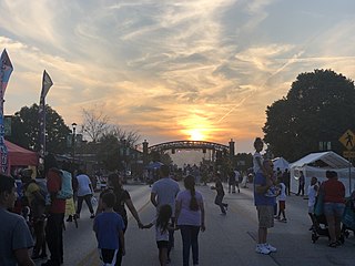
Grandview is a city in Jackson County, Missouri, United States. The population was 24,475 at the 2010 census. It is part of the Kansas City metropolitan area.

<span class="mw-page-title-main">Country Club Hills, Missouri</span> City in Missouri, United States

Country Club Hills is a city in St. Louis County, Missouri, United States. The population was 1,274 at the 2010 census.

<span class="mw-page-title-main">Grandview Heights, Ohio</span> City in Ohio, United States

Grandview Heights, or simply Grandview, is a city in Franklin County, Ohio, United States. The population was 8,085 at the 2020 census.

<span class="mw-page-title-main">Grandview, Hamilton County, Ohio</span> Census-designated place in Ohio, United States

Grandview is a census-designated place (CDP) in Hamilton County, Ohio, United States. The population was 1,312 at the 2020 census.

<span class="mw-page-title-main">Warm Springs, Oregon</span> Unincorporated community in the state of Oregon, United States

Warm Springs is a census-designated place (CDP) and an unincorporated community in Jefferson County, Oregon, United States. Located on the Warm Springs Indian Reservation, the community is also known as the "Warm Springs Agency". The population was 2,945 at the 2010 census, up from 2,431 at the 2000 census.

<span class="mw-page-title-main">North Powder, Oregon</span> City in Oregon, United States

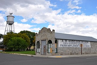
North Powder is a city in Union County, Oregon, United States. The population was 439 at the 2010 census.

<span class="mw-page-title-main">Benton City, Washington</span> City in Washington, United States

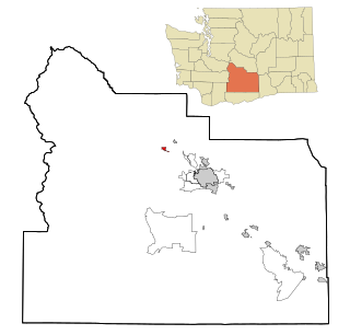
Benton City is a city in Benton County, Washington, United States. The population was 3,479 at the 2020 census. The city shares a school district with the adjacent unincorporated community of Kiona.

<span class="mw-page-title-main">West Richland, Washington</span> City in Washington, United States

West Richland is a city in Benton County, Washington. The population was 16,295 at the time of the 2020 census. The city is part of the Tri-Cities metropolitan area, whose principal cities are Richland, Kennewick, and Pasco.

<span class="mw-page-title-main">Granger, Washington</span> City in Washington, United States

Granger is a city in Yakima County, Washington, United States. The population was 3,624 at the 2020 census. Although it was classified as a town in 2000, it has since been reclassified as a city.

<span class="mw-page-title-main">Union Gap, Washington</span> City in Washington, United States

Union Gap is a city in Yakima County, Washington, United States. As of the 2020 census, the city population was 6,568. Union Gap has become the retail hub for the entire Yakima Valley as a result of Valley Mall and other thriving businesses being located here. Part of the city is part of the Yakama Nation.

<span class="mw-page-title-main">Zillah, Washington</span> City in Washington, United States

Zillah is a city in Yakima County, Washington, United States, with a population of 3,179 as of the 2020 census.

<span class="mw-page-title-main">Grandview, Wisconsin</span> Town in Wisconsin, United States

Grandview is a town in Bayfield County, Wisconsin, United States. The population was 468 at the 2010 census. The unincorporated community of Grand View is located in the town of Grandview.

<span class="mw-page-title-main">Minneiska, Minnesota</span> City in Minnesota, United States

Minneiska is a city in Wabasha and Winona counties in the U.S. state of Minnesota. The population was 111 at the 2010 census.

References

  1. "Grandview Municipal Code". codepublishing.com. Retrieved April 8, 2022.
  2. "Mayor Gloria Mendoza". City of Grandview. Retrieved April 8, 2022.
  3. "2020 U.S. Gazetteer Files". United States Census Bureau. Retrieved July 24, 2022.
  4. 1 2 U.S. Geological Survey Geographic Names Information System: Grandview, Washington
  5. 1 2 3 "Explore Census Data". United States Census Bureau . Retrieved December 4, 2023.
  6. 1 2 "City and Town Population Totals: 2020-2022". United States Census Bureau. December 4, 2023. Retrieved December 4, 2023.
  7. Meany, Edmond S. (1923). Origin of Washington geographic names. Seattle: University of Washington Press. p. 100.
  8. "US Gazetteer files: 2010, 2000, and 1990". United States Census Bureau. February 12, 2011. Retrieved April 23, 2011.
  9. "US Gazetteer files 2010". United States Census Bureau. Archived from the original on January 25, 2012. Retrieved December 19, 2012.
  10. United States Census Bureau. "Census of Population and Housing" . Retrieved June 14, 2014.
  11. Beekman, Daniel (April 8, 2018). "As Seattle police-reform role expands, community group looks to Fé Lopez". The Seattle Times . Retrieved February 24, 2019.
  12. Lester, David (May 17, 2013). "Former Grandview legislator Margaret Rayburn Dies". Yakima Herald-Republic .