Terrace Heights, Washington

Last updated

Terrace Heights, Washington
CDP
Yakima County Washington Incorporated and Unincorporated areas Terrace Heights Highlighted.svg
Location of Terrace Heights, Washington
Coordinates: 46°36′24″N120°27′14″W / 46.60667°N 120.45389°W / 46.60667; -120.45389
CountryUnited States
State Washington
County Yakima
Area
  Total8.2 sq mi (21.2 km2)
  Land7.9 sq mi (20.5 km2)
  Water0.3 sq mi (0.8 km2)
Elevation
1,198 ft (365 m)
Population
 (2020)
  Total9,244
  Density816.3/sq mi (315.2/km2)
Time zone UTC-8 (Pacific (PST))
  Summer (DST) UTC-7 (PDT)
ZIP code
98901 [1]
Area code 509
FIPS code 53-70805 [2]
GNIS feature ID1511364 [3]

Terrace Heights is a census-designated place (CDP) in Yakima County, Washington, United States. The population was 9,244 at the 2020 census. [4] It is essentially a suburb of the city of Yakima.

Contents

Geography

Terrace Heights is located at 46°36′24″N120°27′14″W / 46.60667°N 120.45389°W / 46.60667; -120.45389 (46.606682, -120.454026). [5]

According to the United States Census Bureau, the CDP has a total area of 8.2 square miles (21.2 km2), of which, 7.9 square miles (20.5 km2) of it is land and 0.3 square miles (0.8 km2) of it (3.66%) is water.

Demographics

Historical population
CensusPop.Note
2000 6,447
2010 6,9377.6%
2020 9,24433.3%
U.S. Decennial Census [6] [4]

As of the census [2] of 2007, there were 8,031 people, 3,754 households, and 2,005 families residing in the CDP. The population density was 816.3 people per square mile (315.1/km2). There were 2,609 housing units at an average density of 330.3/sq mi (127.5/km2). The racial makeup of the CDP was 88.58% White, 0.84% African American, 1.13% Native American, 0.51% Asian, 0.02% Pacific Islander, 6.03% from other races, and 2.89% from two or more races. Hispanic or Latino of any race were 11.06% of the population.

There were 3,754 households, out of which 31.4% had children under the age of 18 living with them, 62.0% were married couples living together, 8.7% had a female householder with no husband present, and 26.0% were non-families. 20.9% of all households were made up of individuals, and 8.3% had someone living alone who was 65 years of age or older. The average household size was 2.54 and the average family size was 2.93.

In the CDP, the age distribution of the population shows 24.4% under the age of 18, 7.1% from 18 to 24, 27.1% from 25 to 44, 26.7% from 45 to 64, and 14.7% who were 65 years of age or older. The median age was 40 years. For every 100 females, there were 94.9 males. For every 100 females age 18 and over, there were 93.8 males.

The median income for a household in the CDP was $47,601, and the median income for a family was $53,938. Males had a median income of $39,813 versus $26,925 for females. The per capita income for the CDP was $21,542. About 5.3% of families and 7.5% of the population were below the poverty line, including 7.1% of those under age 18 and 6.0% of those age 65 or over.

Related Research Articles

<span class="mw-page-title-main">East Bronson, Florida</span> Census-designated place in Florida, United States

East Bronson is a census-designated place (CDP) in Levy County, Florida, United States. The population was 1,945 at the 2010 census.

<span class="mw-page-title-main">Coral Terrace, Florida</span> Census-designated place in Florida

Coral Terrace is a suburban unincorporated community and census-designated place (CDP) in Miami-Dade County, Florida, United States. It is part of the Miami metropolitan area of South Florida. The population was 23,142 at the 2020 census, down from 24,376 in 2010.

<span class="mw-page-title-main">Glenvar Heights, Florida</span> Census-designated place in Florida, United States

Glenvar Heights is a census-designated place (CDP) and neighborhood in Miami-Dade County, Florida, United States. The population was 20,786 at the 2020 census, up from 16,898 in 2010. The community is served by the Miami ZIP codes 33143 and 33155.

<span class="mw-page-title-main">Olympia Heights, Florida</span> Census-designated place in Florida, United States

Olympia Heights is a census-designated place in Miami-Dade County, Florida, United States. The population was 12,873 at the 2020 census.
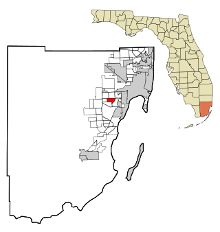
<span class="mw-page-title-main">Holden Heights, Florida</span> Census-designated place in Florida, United States

Holden Heights is a census-designated place and unincorporated area in Orange County, Florida, United States. The population was 3,679 at the 2010 census. The ZIP code serving the CDP is 32839. It is part of the Orlando–Kissimmee Metropolitan Statistical Area.

Long Lake is an unincorporated community and census-designated place (CDP) in Lake County, Illinois, United States. Per the 2020 census, the population was 3,663.

<span class="mw-page-title-main">Redford, New York</span> Census-designated place in New York, United States

Redford is a hamlet and census-designated place in the town of Saranac in Clinton County, New York, United States. The population was 477 at the 2010 census.

<span class="mw-page-title-main">Perry Heights, Ohio</span> CDP in Ohio, United States

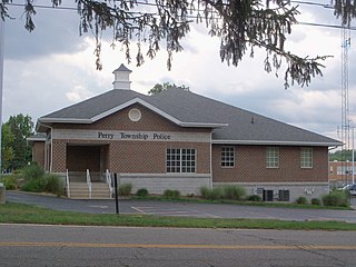
Perry Heights is a census-designated place (CDP) in Stark County, Ohio, United States. The population was 8,900 at the 2000 census. It is part of the Canton-Massillon, OH Metropolitan Statistical Area. It was originally known as Genoa.

<span class="mw-page-title-main">Lenape Heights, Pennsylvania</span> Census-designated place in Pennsylvania, United States

Lenape Heights is a census-designated place (CDP) in Armstrong County, Pennsylvania, United States. The population was 1,144 at the 2020 census.
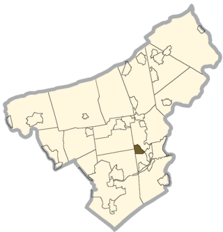
<span class="mw-page-title-main">Ashland Heights, South Dakota</span> CDP in South Dakota, United States

Ashland Heights is a census-designated place (CDP) and unincorporated community in Pennington County, South Dakota, United States. The population was 678 at the 2020 census.

<span class="mw-page-title-main">Longview Heights, Washington</span> CDP in Washington, United States

Longview Heights is a census-designated place (CDP) in Cowlitz County, Washington, United States. The population was 3,851 at the 2010 Census. The CDP is known locally as Columbia Heights.

<span class="mw-page-title-main">Easton, Washington</span> Census-designated place in Washington, United States

Easton is an unincorporated community and census-designated place (CDP) in Kittitas County, Washington, United States. The population was 478 at the 2010 census. Easton is the annual site of the start/finish line for the Cascade Crest 100-mile ultra-running race.

<span class="mw-page-title-main">Ahtanum, Washington</span> CDP in Washington, United States

Ahtanum is a census-designated place (CDP) in Yakima County, Washington. The population was 3,601 at the time of the 2010 census.

<span class="mw-page-title-main">Eschbach, Washington</span> CDP in Washington, United States

Eschbach is a census-designated place (CDP) in Yakima County, Washington, United States. The population was 415 at the 2010 census.

<span class="mw-page-title-main">Gleed, Washington</span> CDP in Washington, United States

Gleed is a census-designated place (CDP) in Yakima County, Washington, United States. The population was 2,906 at the 2010 census.

<span class="mw-page-title-main">Harrah, Washington</span> Town in Washington, United States

Harrah is a town in Yakima County, Washington, United States. The population was 585 at the 2020 census. It is on the Yakama Indian Reservation. The mayor is Barbara Harrer.

<span class="mw-page-title-main">Satus, Washington</span> CDP in Washington, United States

Satus is a census-designated place (CDP) in Yakima County, Washington, United States, located on the eastern corner of the Yakama Indian Reservation. The population was 746 at the 2000 census. It is southwest from the Toppenish National Wildlife Refuge. The community was not recognized in the 2010 census. The area was first settled and established as a post office location in 1890.

<span class="mw-page-title-main">Summitview, Washington</span> CDP in Washington, United States

Summitview is a census-designated place (CDP) in Yakima County, Washington, United States. The population was 967 at the 2010 census.

<span class="mw-page-title-main">West Valley, Washington</span> CDP in Washington, United States

West Valley is a former census-designated place (CDP) in Yakima County, Washington, United States. The area has been annexed by the city of Yakima. The population was 10,433 at the 2000 census.

<span class="mw-page-title-main">White Swan, Washington</span> CDP in Washington, United States

White Swan is a census-designated place (CDP) in Yakima County, Washington, United States. The population was 3,033 at the 2000 census.

References

  1. "Terrace Heights WA ZIP Code". zipdatamaps.com. 2023. Retrieved June 16, 2023.
  2. 1 2 "U.S. Census website". United States Census Bureau . Retrieved January 31, 2008.
  3. "US Board on Geographic Names". United States Geological Survey. October 25, 2007. Retrieved January 31, 2008.
  4. 1 2 "2020 Census Data". United States Census Bureau. Retrieved August 8, 2023.
  5. "US Gazetteer files: 2010, 2000, and 1990". United States Census Bureau. February 12, 2011. Retrieved April 23, 2011.
  6. "Census of Population and Housing". Census.gov. Retrieved June 4, 2016.