
Central is a census-designated place (CDP) in Yukon-Koyukuk Census Area, Alaska, United States. At the 2020 census the population was 66, down from 96 in 2010. Every February, Central hosts a checkpoint for the long-distance Yukon Quest sled dog race.

Wilson-Conococheague is a census-designated place (CDP) in Washington County, Maryland, United States. The population was 2,262 at the 2020 census.
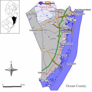
Vista Center is an unincorporated community and census-designated place (CDP) located within Jackson Township in Ocean County, in the U.S. state of New Jersey. As of the 2010 United States Census, the CDP's population was 3,689.

West Hills is a census-designated place (CDP) in Armstrong County, Pennsylvania, United States. The population was 1,228 at the 2020 census.
Woodland Heights is a census-designated place (CDP) in Venango County, Pennsylvania, United States. The population was 1,402 at the 2000 census.

Centerville is a census-designated place (CDP) in Anderson County, South Carolina. The population was 7,185 at the 2020 census.

Blyn is a census-designated place (CDP) in Clallam County, Washington, United States. The population was 101 at the 2010 census, down from 162 at the 2000 census. It is located near the city of Sequim on the shores of Sequim Bay. The area includes the Jamestown S'Klallam Indian Reservation, established in 1874 by the Jamestown S'Klallam Tribe, who named their community Jamestown after their leader; Lord James Balch.

Carlsborg is an unincorporated community and census-designated place (CDP) in Clallam County, Washington, United States. The population was 1,100 at the 2020 census, up from 995 at the 2010 census.

Lakeland North is a census-designated place (CDP) in King County, Washington, United States. The population was 13,663 at the 2020 census. Part of the community was annexed into neighboring Auburn in 2008.
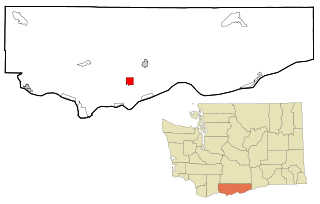
Centerville is an unincorporated community and census-designated place (CDP) in Klickitat County, Washington, United States. Settled in 1877 by Albert J. Brown, the population was 94 at the 2020 census.

Prairie Ridge is a census-designated place (CDP) in Pierce County, Washington, United States. The population was 12,288 at the 2020 census.

Alger is a census-designated place (CDP) in Skagit County, Washington, United States. The population was 507 at the 2020 census. It is included in the Mount Vernon–Anacortes, Washington Metropolitan Statistical Area.

Arlington Heights is a census-designated place (CDP) in Snohomish County, Washington, United States. As of the 2020 census, the population was 2,477, up from 2,284 at the 2010 census.

High Bridge is a census-designated place (CDP) in Snohomish County, Washington, United States. The population was 3,140 at the 2020 census, up from 2,994 at the 2010 census. High Bridge includes the Echo Lake community and the former Echo Lake CDP, which was superseded by the larger High Bridge CDP in 2010.

Lake Bosworth is a census-designated place (CDP) in Snohomish County, Washington, United States. The population was 868 at the 2020 census, up from 667 at the 2010 census.

May Creek is a census-designated place (CDP) in Snohomish County, Washington, United States. The population was 849 at the 2020 census.

Woods Creek is a census-designated place (CDP) in Snohomish County, Washington, United States. The population was 6,017 at the 2020 census.

Satus is a census-designated place (CDP) in Yakima County, Washington, United States, located on the eastern corner of the Yakama Indian Reservation. The population was 746 at the 2000 census. It is southwest from the Toppenish National Wildlife Refuge. The community was not recognized in the 2010 census. The area was first settled and established as a post office location in 1890.
Hampden is a census-designated place (CDP) consisting of the eastern portion of the town of Hampden in Penobscot County, Maine, United States. The population of the CDP was 4,343 at the 2010 census.
Machias is a census-designated place (CDP) corresponding to the central village area within the town of Machias in Washington County, Maine, United States. The population of the CDP was 1,274 at the 2010 census.

