Benton County is a county in the south-central portion of the U.S. state of Washington. As of the 2020 census, its population was 206,873. The county seat is Prosser, and its most populous city is Kennewick. The Columbia River demarcates the county's north, south, and east boundaries.

Yakima is a city in, and the county seat of, Yakima County, Washington, United States, and the state's 11th most populous city. As of the 2020 census, the city had a total population of 96,968 and a metropolitan population of 256,728. The unincorporated suburban areas of West Valley and Terrace Heights are considered a part of greater Yakima.

Yakima County is a county in the U.S. state of Washington. As of the 2020 census, its population was 256,728. The county seat and most populous city is Yakima. The county was formed out of Ferguson County in January 1865 and is named for the Yakama tribe of Native Americans.
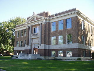
Kittitas County is a county located in the U.S. state of Washington. At the 2020 census, its population was 44,337. Its county seat and largest city is Ellensburg. The county was created in November 1883 when it was carved out of Yakima County. Kittitas County comprises the Ellensburg, Washington, Micropolitan Statistical Area.

Interstate 82 (I-82) is an Interstate Highway in the Pacific Northwest region of the United States that travels through parts of Washington and Oregon. It runs 144 miles (232 km) from its northwestern terminus at I-90 in Ellensburg, Washington, to its southeastern terminus at I-84 in Hermiston, Oregon. The highway passes through Yakima and the Tri-Cities, and is also part of the link between Seattle and Salt Lake City, Utah. I-82 travels concurrently with U.S. Route 97 (US 97) between Ellensburg and Union Gap; US 12 from Yakima to the Tri-Cities; and US 395 from Kennewick to Umatilla, Oregon.
Prosser is a city in and the county seat of Benton County, Washington, United States. Situated along the Yakima River, it had a population of 6,062 at the 2020 census.

Sunnyside is a city in Yakima County, Washington, United States. The population was 16,375 at the 2020 census, making it the second-most populous city in Yakima County.

White Swan is a census-designated place (CDP) in Yakima County, Washington, United States. The population was 789 at the 2020 census.

Zillah is a city in Yakima County, Washington, United States, with a population of 3,179 as of the 2020 census.
The Inland Northwest, historically and alternatively known as the Inland Empire, is a region of the American Northwest centered on the Greater Spokane, Washington Area, encompassing all of Eastern Washington and North Idaho. Under broader definitions, Northeastern Oregon and Western Montana may be included in the Inland Northwest. Alternatively, stricter definitions may exclude Central Washington and Idaho County, Idaho.

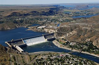
State Route 24 (SR 24) is a state highway in the south-central region of Washington, in the United States. It travels 79 miles (127 km) from Yakima to Othello, across a portion of the Columbia Plateau. The highway crosses the Columbia River on the Vernita Bridge, located near the Hanford Site. SR 24 terminates to the west at an interchange with Interstate 82 (I-82) in Yakima and to the east at SR 26 in Othello.

State Route 823 (SR 823) is a state highway in Yakima County, Washington, United States. It runs for 5.6 miles (9.0 km) from an interchange with U.S. Route 12 (US 12) and through the city of Selah to a junction with SR 821. A portion of the highway runs in the median of Interstate 82 (I-82), its parent route, as it crosses the Naches River.

State Route 223 (SR 223) is a 3.81-mile (6.13 km) long state highway located entirely in Yakima County, Washington, United States. It has served the role of connecting the city of Granger to the county seat, Yakima via Interstate 82 and to SR 22 since its establishment in 1967, serving between 4,000 and 8,500 cars per day on average in 2009.

State Route 241 (SR 241) is a north–south state highway serving Yakima and Benton counties in the U.S. state of Washington. The 25-mile (40 km) highway begins at SR 22 in Mabton and travels north to Sunnyside, where it intersects Interstate 82 (I-82) and U.S. Route 12 (US 12). SR 241 continues north into the Rattlesnake Hills and ends at a junction with SR 24.

The following outline is provided as an overview of and topical guide to the U.S. state of Washington:
Donald is a census-designated place and unincorporated community in Yakima County, Washington, United States. The population was 91 at the 2010 census.
Wiley City is an unincorporated community in Yakima County, Washington, United States, located near the southwest city limits of Yakima.
Tampico is a census-designated place and unincorporated community in Yakima County, Washington, United States, located approximately eighteen miles west of Yakima on Ahtanum Creek. The population was 312 at the 2010 United States Census.
Nile is a census-designated place and unincorporated community in Yakima County, Washington, United States, located approximately 35 miles northwest of Yakima in the Nile Valley adjacent to the Naches River in the Nile Valley, near the mouth of Rattlesnake Creek.
Fruitvale is an unincorporated community in Yakima County, Washington, United States, located within the north city limits of Yakima.


