West Richland, Washington

Last updated

West Richland, Washington
City of West Richland
WestRichlandCityHall2022.jpg
West Richland's current City Hall complex on Belmont Blvd.
Benton County Washington Incorporated and Unincorporated areas West Richland Highlighted.svg
Location of West Richland, Washington
Coordinates: 46°17′32″N119°21′16″W / 46.29222°N 119.35444°W / 46.29222; -119.35444
CountryUnited States
State Washington
County Benton
IncorporatedJune 13, 1955 [1]
Government
  Type Mayor-Council [2]
  MayorBrent Gerry
  Mayor Pro TemFred Brink [3]
Area
[4]
  Total22.28 sq mi (57.71 km2)
  Land22.11 sq mi (57.28 km2)
  Water0.17 sq mi (0.43 km2)
Elevation
413 ft (126 m)
Population
 (2020) [5]
  Total16,295
  Estimate 
(2021) [6]
16,951
  Density730/sq mi (280/km2)
Time zone UTC-8 (Pacific (PST))
  Summer (DST) UTC-7 (PDT)
ZIP codes
99352-99353
Area code 509
Official flower Phlox longifolia [lower-alpha 1]
GNIS feature ID1512794 [7]
Website westrichland.org

West Richland is a city in Benton County, Washington. The population was 16,295 at the time of the 2020 census. [5] The city is part of the Tri-Cities metropolitan area, whose principal cities (the Tri-Cities) are Richland, Kennewick, and Pasco.

Contents

History

West Richland as seen across Yakima from Richland. West Richland - as seen across Yakima River - Flat Top hill to right - houses in highlands behind - July 2013.jpg
West Richland as seen across Yakima from Richland.

The original people of the region were the Chemnapum Indians (closely related to the Wanapum tribe), living near the mouth of the Yakima River. Lewis and Clark passed through the area in 1805, and an expedition of the Army Corps of Topographical Engineers headed by Robert E Johnson mapped the Yakima Valley in 1841. [ citation needed ]

In 1853, a road was authorized by Congress to pass through the Yakima Valley, and passed through present-day West Richland; however, settlement did not properly begin until the late 1870s. The first schoolhouse was built in 1896 on the Van Horn Property just south of what is now Van Giesen Street. Benton County was created in 1905, Richland was incorporated in 1906, and the West Richland area was known as 'Lower Yakima'. [ citation needed ]

An irrigation canal from the north side of Horn Rapids Dam was built in 1908 to bring water into Richland. [ citation needed ]

The Yellowstone Trail, a national highway stretching from Albany, New York, to Seattle, was located through the Yakima Valley in 1917 and 1918. It crossed the Fallon Bridge between Richland and West Richland and then proceeded directly west to Kiona. [ citation needed ]

During the 1940s, the city of Richland was built, run and maintained by the War Department for the duration of the Manhattan Project. A number of residents had chafed at the government's regulations, and as a result many of them had moved across the Yakima River, where it was possible to purchase land and own (rather than rent) a house. [ citation needed ]

Carl Heminger purchased some 80 acres (320,000 m2) in 1948, and laid out plans for a city. It was proposed that it be named Heminger City (presumably after himself), but in 1949 the townspeople chose the name Enterprise instead. Heminger moved a mile down the road in protest, and platted a small community there called Heminger City. This was eventually incorporated in the West Richland City limits. When the time came in 1955 to incorporate the town, it was decided to rename to West Richland, taking advantage of the already well-known status of nearby Richland. [ citation needed ] West Richland was officially incorporated on June 17, 1955, combining the two towns of Heminger City and Enterprise. [ citation needed ]

In 2008, West Richland was the location of the speed test for the fastest production car in the world (the Aero SSC TT) at over 250 mph (400 km/h). [8]

Geography

West Richland is located at 46°17′32″N119°21′16″W / 46.29222°N 119.35444°W / 46.29222; -119.35444 (46.292085, -119.354417). [9] According to the United States Census Bureau, the city has a total area of 22.12 square miles (57.29 km2), of which, 21.92 square miles (56.77 km2) is land and 0.20 square miles (0.52 km2) is water. [10]

Climate

According to the Köppen Climate Classification system, West Richland has a semi-arid climate, abbreviated "BSk" on climate maps, falling slightly short of being classified as a desert climate. [11]

Climate data for West Richland, Washington
MonthJanFebMarAprMayJunJulAugSepOctNovDecYear
Average high °C (°F)4
(39)
8
(47)
14
(57)
18
(65)
22
(72)
26
(79)
30
(86)
29
(85)
25
(77)
18
(64)
9
(48)
3
(38)
17
(63)
Average low °C (°F)−3
(26)
−2
(29)
1
(33)
3
(38)
7
(44)
11
(51)
13
(55)
13
(55)
9
(48)
4
(39)
0
(32)
−3
(26)
4
(40)
Average precipitation mm (inches)28
(1.1)
23
(0.9)
20
(0.8)
20
(0.8)
18
(0.7)
15
(0.6)
7.6
(0.3)
7.6
(0.3)
10
(0.4)
15
(0.6)
28
(1.1)
33
(1.3)
230
(8.9)
Source: Weatherbase [12]

Demographics

Historical population
CensusPop.Note
1960 1,347
1970 1,107−17.8%
1980 2,938165.4%
1990 3,96234.9%
2000 8,385111.6%
2010 11,81140.9%
2020 16,29538.0%
2021 (est.)16,951 [6] 4.0%
U.S. Decennial Census [13] 2020 [5]

2020 census

As of the 2020 census, there were 16,295 people and 4,640 households in the city. The population density was 731.4 per square mile (282.4/km2). The racial makeup of the city was 86.9% White, 1.3% African American, 0.1% Native American, 1.2% Asian, 0.3% Pacific Islander, 3.5% from other races, and 6.7% from two or more races. Hispanic or Latino of any race were 13.4% of the population. Non-Hispanic Whites comprised 80.3% of the population.

There were 4,640 households with an average number of 3.2 persons per household. The median income for a household in the city was $102,974. The per capita income for the city was $36,735. About 7% of persons were below the poverty line. There were 933 Veterans in the city and 6.2% of the population was foreign born. [14]

2010 census

As of the 2010 census, there were 11,811 people, 4,145 households, and 3,253 families living in the city. The population density was 538.8 inhabitants per square mile (208.0/km2). There were 4,298 housing units at an average density of 196.1 per square mile (75.7/km2). The racial makeup of the city was 90.3% White, 0.8% African American, 1.2% Native American, 1.9% Asian, 0.2% Pacific Islander, 2.4% from other races, and 3.2% from two or more races. Hispanic or Latino of any race were 7.1% of the population.

There were 4,145 households, of which 43.1% had children under the age of 18 living with them, 65.7% were married couples living together, 8.7% had a female householder with no husband present, 4.1% had a male householder with no wife present, and 21.5% were non-families. 17.0% of all households were made up of individuals, and 4.5% had someone living alone who was 65 years of age or older. The average household size was 2.85 and the average family size was 3.22.

The median age in the city was 35.4 years. 29.6% of residents were under the age of 18; 7% were between the ages of 18 and 24; 27.7% were from 25 to 44; 27.5% were from 45 to 64; and 8.3% were 65 years of age or older. The gender makeup of the city was 50.5% male and 49.5% female.

2000 census

As of the 2000 census, there were 8,385 people, 2,937 households, and 2,305 families living in the city. The population density was 386.1 per square mile (149.1/km2). There were 3,092 housing units at an average density of 142.4 per square mile (55.0/km2). The racial makeup of the city was 93.18% White, 0.56% African American, 0.50% Native American, 1.65% Asian, 0.02% Pacific Islander, 1.86% from other races, and 2.23% from two or more races. Hispanic or Latino of any race were 4.83% of the population.

There were 2,937 households, out of which 45.9% had children under the age of 18 living with them, 66.9% were married couples living together, 7.9% had a female householder with no husband present, and 21.5% were non-families. 17.2% of all households were made up of individuals, and 4.0% had someone living alone who was 65 years of age or older. The average household size was 2.85 and the average family size was 3.24.

In the city, the age distribution of the population shows 32.7% under the age of 18, 6.3% from 18 to 24, 33.3% from 25 to 44, 21.7% from 45 to 64, and 6.1% who were 65 years of age or older. The median age was 33 years. For every 100 females, there were 101.5 males. For every 100 females age 18 and over, there were 99.9 males.

The median income for a household in the city was $57,750, and the median income for a family was $61,813. Males had a median income of $50,785 versus $29,595 for females. The per capita income for the city was $22,499. About 3.9% of families and 4.5% of the population were below the poverty line, including 5.5% of those under age 18 and 6.7% of those age 65 or over.

Culture

The 2018 West Richland Veteran's Day Parade. West Richland Veteran's Day - 2018.jpg
The 2018 West Richland Veteran's Day Parade.

Events


Businesses

Notable people

Notes

  1. Officially, the city flower is "Phlox", however the native Phlox species is Phlox longifolia

Related Research Articles

<span class="mw-page-title-main">Richland, Washington</span> City in Washington, United States

Richland is a city in Benton County, Washington, United States. It is located in southeastern Washington at the confluence of the Yakima and the Columbia Rivers. As of the 2020 census, the city's population was 60,560. Along with the nearby cities of Pasco and Kennewick, Richland is one of the Tri-Cities, and is home to the Hanford nuclear site.

<span class="mw-page-title-main">Benton County, Washington</span> County in Washington, United States

Benton County is a county in the south-central portion of the U.S. state of Washington. As of the 2020 census, its population was 206,873. The county seat is Prosser, and its largest city is Kennewick. The Columbia River demarcates the county's north, south, and east boundaries.

<span class="mw-page-title-main">Yakima County, Washington</span> County in Washington, United States

Yakima County is a county in the U.S. state of Washington. As of the 2020 census, its population was 256,728. The county seat and largest city is Yakima. The county was formed out of Ferguson County in January 1865 and is named for the Yakama tribe of Native Americans.

<span class="mw-page-title-main">Richland County, Ohio</span> County in Ohio, United States

Richland County is a county located in the U.S. state of Ohio. As of the 2020 census, the population was 124,936. Its county seat is Mansfield. The county was created in 1808 and later organized in 1813. It is named for the fertile soil found there.

<span class="mw-page-title-main">Richland, Mississippi</span> City in Mississippi, United States

Richland is a city in Rankin County, Mississippi, United States. The population was 6,912 at the 2010 census. A suburb of Jackson, Richland is part of the Jackson Metropolitan Statistical Area, and is located southeast of the state capital.

<span class="mw-page-title-main">Richland, Oregon</span> City in Oregon, United States

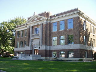
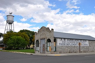
Richland is a city in Baker County, Oregon, United States. The population was 156 at the 2010 census.

<span class="mw-page-title-main">North Powder, Oregon</span> City in Oregon, United States

North Powder is a city in Union County, Oregon, United States. The population was 439 at the 2010 census.

<span class="mw-page-title-main">Benton City, Washington</span> City in Washington, United States

Benton City is a city in Benton County, Washington, United States. The population was 3,479 at the 2020 census. The city shares a school district with the adjacent unincorporated community of Kiona.

<span class="mw-page-title-main">Prosser, Washington</span> City in Washington, United States

Prosser is a city in and the county seat of Benton County, Washington, United States. Situated along the Yakima River, it had a population of 6,062 at the 2020 census.

<span class="mw-page-title-main">Pasco, Washington</span> City in Washington, United States

Pasco is a city in, and the county seat of, Franklin County, Washington, United States. The population was 77,108 at the 2020 census, and 79,315 as of the July 1, 2022 estimate.

<span class="mw-page-title-main">Grandview, Washington</span> City in Washington, United States

Grandview is a city in Yakima County, Washington, United States. It is about 38 miles west of Kennewick and 38 miles southeast of Yakima. The population was 10,907 at the 2020 census. Grandview's economy is agriculture based; with apples, cherries, concord and wine grapes, hops, asparagus, corn, wheat, dairy and other fruit and vegetable production supported by processing plants and cold storage facilities.

<span class="mw-page-title-main">Granger, Washington</span> City in Washington, United States

Granger is a city in Yakima County, Washington, United States. The population was 3,624 at the 2020 census. Although it was classified as a town in 2000, it has since been reclassified as a city.

<span class="mw-page-title-main">Harrah, Washington</span> Town in Washington, United States

Harrah is a town in Yakima County, Washington, United States. The population was 585 at the 2020 census. It is on the Yakama Indian Reservation. The mayor is Barbara Harrer.

<span class="mw-page-title-main">Moxee, Washington</span> City in Washington, United States

Moxee is a small suburban community southeast of Yakima, Washington. Yakima and Moxee are both north of the Yakama Indian Reservation in Yakima County, Washington, United States. The population of Moxee was 4,326 at the 2020 census.

<span class="mw-page-title-main">Naches, Washington</span> Town in Washington, United States

Naches is a town in Yakima County, Washington, United States. The population was 1,084 at the 2020 census.

<span class="mw-page-title-main">Satus, Washington</span> CDP in Washington, United States

Satus is a census-designated place (CDP) in Yakima County, Washington, United States, located on the eastern corner of the Yakama Indian Reservation. The population was 746 at the 2000 census. It is southwest from the Toppenish National Wildlife Refuge. The community was not recognized in the 2010 census. The area was first settled and established as a post office location in 1890.

<span class="mw-page-title-main">Terrace Heights, Washington</span> CDP in Washington, United States

Terrace Heights is a census-designated place (CDP) in Yakima County, Washington, United States. The population was 9,244 at the 2020 census. It is essentially a suburb of the city of Yakima.

<span class="mw-page-title-main">Union Gap, Washington</span> City in Washington, United States

Union Gap is a city in Yakima County, Washington, United States. As of the 2020 census, the city population was 6,568. Union Gap has become the retail hub for the entire Yakima Valley as a result of Valley Mall and other thriving businesses being located here. Part of the city is part of the Yakama Nation.

<span class="mw-page-title-main">West Valley, Washington</span> CDP in Washington, United States

West Valley is a former census-designated place (CDP) in Yakima County, Washington, United States. The area has been annexed by the city of Yakima. The population was 10,433 at the 2000 census.

<span class="mw-page-title-main">Lone Rock, Wisconsin</span> Village in Wisconsin, United States

Lone Rock is a village in Richland County, Wisconsin, United States. The population was 888 at the 2010 census. The village is named after a sandstone outcrop.

References

  1. "City of West Richland History: 1955-2005". City of West Richland. Retrieved April 30, 2018.
  2. "City of West Richland, Washington" . Retrieved December 28, 2015.
  3. "City Council". City of West Richland. Retrieved March 26, 2022.
  4. "2019 U.S. Gazetteer Files". United States Census Bureau. Retrieved August 7, 2020.
  5. 1 2 3 "Explore Census Data". data.census.gov. Retrieved September 8, 2022.
  6. 1 2 "U.S. Census Bureau QuickFacts: West Richland city, Washington". United States Census Bureau. July 2021. Retrieved July 19, 2022.
  7. "US Board on Geographic Names". United States Geological Survey. October 25, 2007. Retrieved January 31, 2008.
  8. Olasoji, Amujo (July 29, 2021). "Here's How The Bugatti Chiron's Top Speed Compares With Its Rivals". HotCars. Retrieved July 20, 2022.
  9. "US Gazetteer files: 2010, 2000, and 1990". United States Census Bureau. February 12, 2011. Retrieved April 23, 2011.
  10. "US Gazetteer files 2010". United States Census Bureau . Retrieved December 19, 2012.
  11. Climate Summary for West Richland, Washington
  12. "Weatherbase.com". Weatherbase. 2014. Retrieved on June 4, 2014
  13. "U.S. Census Bureau QuickFacts: West Richland city, Washington". Census.gov. Retrieved July 19, 2022.
  14. "U.S. Census Bureau QuickFacts: West Richland city, Washington". www.census.gov. Retrieved October 2, 2022.
  15. "Veterans Day Parade | West Richland, WA". W Richland Chamber. Archived from the original on November 12, 2023. Retrieved November 29, 2023.
  16. Richardson, Tyler (September 5, 2013). "Kennewick powerlifter gets 30 months in federal prison for importing steroids". Tri-City Herald . Retrieved April 3, 2016.
  17. "Winners of RM Met Auditions". rmauditions.org. 2008. Retrieved May 13, 2009.