
Browns Park National Wildlife Refuge is a 13,450-acre (5,440 ha) U.S. National Wildlife Refuge located in northwestern Colorado. It is located in Moffat County in the extreme northwestern corner of the state, in an isolated mountain valley of Browns Park on both sides of the Green River, approximately 25 miles (40 km) below Flaming Gorge Dam. Established in 1965, the refuge is managed by the United States Fish and Wildlife Service office in Maybell, Colorado. The refuge is approximately 53 miles (85 km) northwest of Maybell on State Highway 318. The refuge consists of bottomland and adjacent benchland. The western border of the refuge is the Colorado-Utah state line. The refuge is surrounded by adjacent lines of the Bureau of Land Management. The refuge contains the site of the former Fort Davy Crockett that was constructed in 1837 to protect trappers against attacks by Blackfoot Native Americans.

The Lower Klamath National Wildlife Refuge is a National Wildlife Refuge of the United States on the border between California and Oregon. It is operated by the United States Fish and Wildlife Service. The refuge was designated a National Historic Landmark on October 16, 1965.

The Erie National Wildlife Refuge is an 8,777-acre (3,552 ha) National Wildlife Refuge located in Crawford County, Pennsylvania. Named after the Erie tribe, it was established to provide waterfowl and other migratory birds with nesting, feeding, brooding, and resting habitat.
Cross Creeks National Wildlife Refuge is a part of the U.S. system of National Wildlife Refuges located along the Lake Barkley impoundment of the Cumberland River in Stewart County, Tennessee near Dover, covering 8,862 acres (35.86 km2). It provides habitat for a wide variety of waterfowl and aquatic plant life in what is a largely wetlands environment. Cross Creeks is the only National Wildlife Refuge located entirely in Middle Tennessee as of 2006.

William L. Finley National Wildlife Refuge is a natural area in the Willamette Valley in Oregon, United States. It was created to provide wintering habitat for dusky Canada geese. Unlike other Canada geese, dusky Canada geese have limited summer and winter ranges. They nest on Alaska's Copper River Delta and winter almost exclusively in the Willamette Valley. Habitat loss, predation, and hunting have caused a decrease in population.
Ankeny National Wildlife Refuge is located in the fertile Willamette Valley of northwestern Oregon, 12 miles (19 km) south of Salem. The valley was once a rich mix of wildlife habitats. Valley wetlands were once extensive, with meandering stream channels and vast seasonal marshes. Today, the valley is a mix of farmland and growing cities, with few areas remaining for wildlife.
The Cypress Creek National Wildlife Refuge is located in the Cache River watershed in southernmost Illinois, largely in Pulaski County, but with extensions into Union, Alexander, and Johnson counties. The refuge was established in 1990 under the authority of the Emergency Wetlands Resources Act of 1986. The refuge protects over 16,000 acres (65 km2) of the Cache River wetlands, and has a purchase boundary of 36,000 acres (146 km²) contiguous.

The Turnbull National Wildlife Refuge is located six miles (10 km) south of Cheney, Washington, on the eastern edge of the Columbia Basin in Spokane County in northeastern Washington. Turnbull NWR encompasses more than 23,000 acres (9,300 ha) of the Channeled Scablands. The ecosystem that predominates the refuge is unique within the National Wildlife Refuge System and has characteristics that distinguish it from natural reserves worldwide. The combination of basalt outcrops, channeled canyons, and ponderosa pine forests infused in a diverse landscape of over 130 marshes, wetlands, and lakes creates an environment of aesthetic beauty as well as high quality wildlife habitat. The refuge is named for Cyrus Turnbull who lived on the site in the 1880s.
San Pablo Bay National Wildlife Refuge is a 13,190-acre (53.4 km2) National Wildlife Refuge in California established in 1970. It extends along the northern shore of San Pablo Bay, from the mouth of the Petaluma River, to Tolay Creek, Sonoma Creek, and ending at Mare Island.
D'Arbonne National Wildlife Refuge is a National Wildlife Refuge of the United States located north of West Monroe, Louisiana. It is in Ouachita and Union Parishes on either side of Bayou D'Arbonne near its confluence with the Ouachita River. It lies on the western edge of the Mississippi River alluvial valley. It was established in 1975 to protect bottomland hardwoods and provide wintering habitat for migratory waterfowl. D'Arbonne is one of four refuges managed in the North Louisiana Refuges Complex.
Handy Brake National Wildlife Refuge is located just north of Bastrop, Louisiana in Morehouse Parish, north central Louisiana. The refuge was established in 1988 with the southeast's first fee title transfer of a Farmer's Home Administration tract to the U.S. Fish and Wildlife Service. A free lease of 38 acres (150,000 m2) from International Paper increased the refuge to the current 501 acres (2.03 km2).
Union Slough National Wildlife Refuge, located in Kossuth County, Iowa, was established in 1938 to provide a refuge and breeding ground for waterfowl and other migratory birds. The actual slough is all that remains of a pre-glacial riverbed, and its name is derived from the connection or "union" of two watersheds: the Blue Earth River of Minnesota and the East Fork of the Des Moines River. The terrain is nearly flat, allowing the flow of the water to be determined by the direction of the wind at times.

Hamden Slough National Wildlife Refuge is a National Wildlife Refuge of the United States in Minnesota. Eastern hardwood forests stretching from the Atlantic seaboard give way to the western prairie at the area, in Audubon Township, near Audubon, Minnesota. Prior to settlement, its diverse vegetation was attractive to wildlife: waterfowl, upland birds, bison, wolves, and other prairie wildlife. When fully restored, the refuge will provide the largest contiguous block of wetland prairie habitat in the region, encompassing nearly 6,000 acres (24 km2).
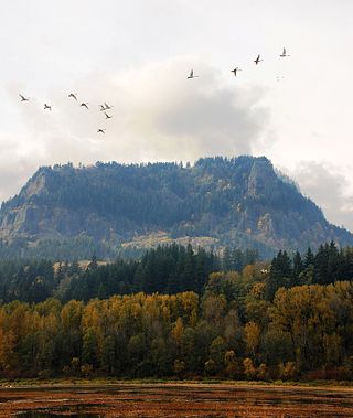
Franz Lake National Wildlife Refuge is located in southwest Washington state, within the Columbia River Gorge National Scenic Area. The refuge provides a variety of habitats including riparian wetlands, Columbia River riparian corridor blocks, transitional woodlands from lower elevation willows, and cottonwoods to mid-elevation old-growth fir and cedar with associated native understory shrubs, open meadows, and numerous streams and seeps.

The Umatilla National Wildlife Refuge is located on and around the Columbia River about 15 miles (24 km) northwest of Hermiston, Oregon and includes 8,907 acres (3,605 ha) in Oregon, and 14,876 acres (6,020 ha) in Washington. It was established in 1969 to help mitigate habitat lose due to the flooding that occurred following the construction of the John Day Dam. The refuge is popular with birdwatchers and wildlife enthusiasts.

McKay Creek National Wildlife Refuge is a United States National Wildlife Refuge located between plains and the Blue Mountains of Eastern Oregon. The refuge provides habitat for rare and endangered species and breeding and migratory birds. The lack of other local wetland habitats elevates the importance of this refuge as a home to a variety of wildlife and plant species in an arid environment.

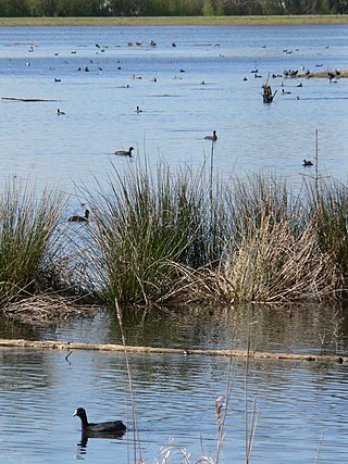
Colusa National Wildlife Refuge is one of six refuges in the Sacramento National Wildlife Refuge Complex located in the Sacramento Valley of north-central California. The refuge is located in Colusa County. It is around 70 miles (110 km) north of metropolitan Sacramento.

Butte Sink Wildlife Management Area is located in Colusa, Butte, and Sutter Counties. It is wetlands managed as part of the Sacramento National Wildlife Refuge Complex and is not open to the public.

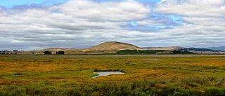
The Summer Lake Wildlife Area is a 29.6-square-mile (77 km2) wildlife refuge located on the northwestern edge of the Great Basin drainage in south-central Oregon. It is administered by the Oregon Department of Fish and Wildlife. The refuge is an important stop for waterfowl traveling along the Pacific Flyway during their spring and fall migrations. The Summer Lake Wildlife Area also provides habitat for shorebirds and other bird species as well as wide variety of mammals and several fish species. The Ana River supplies the water for the refuge wetlands.
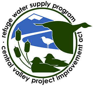
The Refuge Water Supply Program (RWSP) is administered by the United States Department of the Interior jointly by the Bureau of Reclamation and Fish and Wildlife Service and tasked with acquiring a portion and delivering a total of 555,515 acre feet (AF) of water annually to 19 specific protected wetland areas in the Central Valley of California as mandated with the passing of the Central Valley Project Improvement Act signed on October 30, 1992, by President George H. W. Bush.
