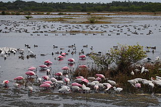
Merritt Island National Wildlife Refuge is a 140,000 acres (57,000 ha) U.S. National Wildlife Refuge (NWR) on the Atlantic coast of Florida's largest barrier island. NASA's Kennedy Space Center and visitor complex are also situated on the island and NASA can restrict access to the refuge based on its operational needs.

The Great Meadows National Wildlife Refuge is a 12-mile-long (19 km) river wetlands conservation area, in two major parcels, stretching from the towns of Billerica, Massachusetts (downstream) to Wayland, Massachusetts (upstream), along the Concord River and Sudbury River.

The Erie National Wildlife Refuge is an 8,777-acre (3,552 ha) National Wildlife Refuge located in Crawford County, Pennsylvania. Named after the Erie tribe, it was established to provide waterfowl and other migratory birds with nesting, feeding, brooding, and resting habitat.
Ankeny National Wildlife Refuge is located in the fertile Willamette Valley of northwestern Oregon, 12 miles (19 km) south of Salem. The valley was once a rich mix of wildlife habitats. Valley wetlands were once extensive, with meandering stream channels and vast seasonal marshes. Today, the valley is a mix of farmland and growing cities, with few areas remaining for wildlife.

The Mingo National Wildlife Refuge is a 21,676-acre (87.7-km2) National Wildlife Refuge located in northwestern Stoddard and southeastern Wayne counties in Missouri. Its southwesternmost portion lies on the shores of Lake Wappapello. Named after the Mingo tribe, it was established to preserve bottomland hardwoods and provide waterfowl and other migratory birds in the Mississippi Flyway with nesting, feeding, brooding, and resting habitat.

Baskett Slough National Wildlife Refuge is in northwestern Oregon, 10 miles (16 km) west of Salem in Polk County. The Refuge consists of 1,173 acres (4.75 km²) of cropland, which provide forage for wintering geese, 300 acres (1.2 km²) of forests, 550 acres (2.2 km²) of grasslands, and 500 acres (2.0 km²) of shallow water seasonal wetlands and 35 acres (0.14 km²) of permanent open water. In 1965, Baskett Slough National Wildlife Refuge was created to help ensure some of the original habitat remained for species preservation. The refuge is managed by the U.S. Fish and Wildlife Service, an agency of the U.S. Department of the Interior.

The Tualatin River National Wildlife Refuge is a 1,856 acres (751 ha) wetlands and lowlands sanctuary in the northwestern part of the U.S. state of Oregon. Established in 1992 and opened to the public in 2006, it is managed by the United States Fish and Wildlife Service. Located in southeastern Washington County, 15 miles (24 km) southwest of Portland, the refuge is bordered by Sherwood, Tualatin and Tigard. A newer area, extending into northern Yamhill County, is located further west near the city of Gaston surrounding the former Wapato Lake.

Audubon National Wildlife Refuge is a 14,739-acre (5,965 ha) National Wildlife Refuge in the U.S. state of North Dakota. The refuge is managed by the U.S. Fish and Wildlife Service and is the centerpiece of the Audubon National Wildlife Refuge Complex, which includes numerous other refuges in the region. Originally designated as the Snake Creek National Wildlife Refuge in 1955, the refuge was renamed in 1967 in honor of the artist and naturalist John James Audubon. Most of the refuge area is a lake known as Audubon Lake which is managed by the U.S. Army Corps of Engineers.

Lake Ilo National Wildlife Refuge (NWR) is located in the U.S. state of North Dakota and is managed from Audubon National Wildlife Refuge by the U.S. Fish and Wildlife Service. The refuge consists of Lake Ilo, surrounding wetlands and some upland range, providing habitat for hundreds of species of birds, and numerous fish and mammal species. An average of over 16 inches (40 cm) of precipitation falls annually, supporting a prairie ecosystem.
The Des Lacs National Wildlife Refuge is located in the U.S. state of North Dakota and extends from the Canada–United States border to near the town of Kenmare, North Dakota along Des Lacs Lake. The refuge was established in 1935 and includes 19,500 acres (78.9 km2). The refuge is considered to be one of the most important bird sanctuaries in the U.S., with tens of thousands of birds using the refuge for migration and breeding. The refuge is also home to elk, moose, bison and pronghorn.

Sherburne National Wildlife Refuge is a National Wildlife Refuge of the United States in Sherburne County, Minnesota. The 30,700-acre (124 km2) refuge protects mixed habitat types including oak savanna, Big Woods, and wetlands. The St. Francis River flows through the eastern side of the park. Over 230 species of birds, 58 species of mammals, and 25 species of reptiles and amphibians have been recorded in the refuge.
The Dungeness National Wildlife Refuge is located near the town of Sequim in Clallam County in the U.S. state of Washington, on the Strait of Juan de Fuca. The refuge is composed of 772.52 acres (312.63 ha) which include Dungeness Spit, Graveyard Spit, and portions of Dungeness Bay and Harbor. Dungeness Spit is one of the world's longest natural sand spits, 6.8 miles (10.9 km) long and very narrow. A lighthouse, the New Dungeness Light, built in 1857, is located near the end of the spit. Access to Dungeness Spit is through a Clallam County Park which has hiking trails, picnic areas, and a campground. On January 20, 1915, it was designated as a National Wildlife Refuge by President Woodrow Wilson. Dungeness is one of six refuges in the Washington Maritime National Wildlife Refuge Complex.

The Turnbull National Wildlife Refuge is located six miles (10 km) south of Cheney, Washington, on the eastern edge of the Columbia Basin in Spokane County in northeastern Washington. Turnbull NWR encompasses more than 18,000 acres (7,300 ha) of the Channeled Scablands. The ecosystem that predominates the refuge is unique within the National Wildlife Refuge System and has characteristics that distinguish it from natural reserves worldwide. The combination of basalt outcrops, channeled canyons, and ponderosa pine forests infused in a diverse landscape of over 130 marshes, wetlands, and lakes creates an environment of aesthetic beauty as well as high quality wildlife habitat. The refuge is named for Cyrus Turnbull who lived on the site in the 1880s.

Minidoka National Wildlife Refuge is located on the Snake River Plain in south-central Idaho, 12 miles (19 km) northeast of Rupert. It includes about 80 miles (130 km) of shoreline around Lake Walcott, from Minidoka Dam upstream about 25 miles (40 km).
Aroostook National Wildlife Refuge is located on part of the former Loring Air Force Base, in Aroostook County, Maine. It was established in 1998, when 4,700 acres (19 km2) were transferred from the United States Air Force to the United States Fish and Wildlife Service. This refuge also administers some 2,400 acres (970 ha) of wetland conservation easements throughout Aroostook County. It is close to the Aroostook State Park where visitors can camp, hike, fish, and cross-country ski. In a portion of Maine where the landscape is dominated by agricultural crops such as potatoes and broccoli, Aroostook National Wildlife Refuge protects valuable wildlife habitat. The variety of habitat types attracts a diversity of wildlife species.

Straddling the headwaters of the Minnesota River in west-central Minnesota, Big Stone National Wildlife Refuge is within the heart of the tallgrass prairie's historic range. Today, less than one-percent of tallgrass prairie remains.

Ottawa National Wildlife Refuge is a National Wildlife Refuge of the United States, which is located in the state of Ohio. This refuge was established in 1961, under the Migratory Bird Conservation Act, the purpose of the refuge being created was “… for use as an inviolate sanctuary, or for any other management purpose, for migratory birds.” 16 U.S.C. 715d. This refuge provides ideal habitat for a wide range for migratory birds and waterfowl, along with the native wildlife, and any endangered and threatened species. The property of the refuge was purchased from hunt clubs and farmlands with the Federal Duck Stamps.

Hagerman National Wildlife Refuge (HNWR), a haven for migratory birds and other wildlife, lies in northwestern Grayson County, Texas, on the Big Mineral Arm of Lake Texoma, on the Red River between Oklahoma and Texas. This National Wildlife Refuge is made up of water, marsh, and upland habitat. Visitors can hike, observe wildlife, hunt, and fish throughout the year.
Cold Springs National Wildlife Refuge is a 3,117-acre (12.61 km2) National Wildlife Refuge located 7 miles (10 km) northeast of Hermiston and 3 miles (5 km) south of the Columbia River in Umatilla County, Oregon; The refuge was established in 1909 as a preserve and breeding ground for native birds. It consists of diverse wetland habitats surrounded by upland habitat of big sagebrush and native steppe grasses. A riparian component of willow and cottonwood provides refuge for birds, mammals, and other animals.

The Summer Lake Wildlife Area is a 29.6-square-mile (77 km2) wildlife refuge located on the northwestern edge of the Great Basin drainage in south-central Oregon. It is administered by the Oregon Department of Fish and Wildlife. The refuge is an important stop for waterfowl traveling along the Pacific Flyway during their spring and fall migrations. The Summer Lake Wildlife Area also provides habitat for shorebirds and other bird species as well as wide variety of mammals and several fish species. The Ana River supplies the water for the refuge wetlands.

