Billy Frank Jr. Nisqually National Wildlife Refuge

Last updated
Billy Frank Jr. Nisqually National Wildlife Refuge
IUCN category IV (habitat/species management area)
Nisqually NWR 28077.JPG
USA Washington location map.svg
Red pog.svg
Location in Washington state
Location Thurston and Pierce counties, Washington, USA
Nearest city Lacey, WA
Coordinates 47°04′57″N122°43′18″W / 47.08250°N 122.72167°W / 47.08250; -122.72167 [1]
Area4,529.21 acres (18.3291 km2) [3]
Established1974 (1974) [4]
Named for Billy Frank, Jr.
Visitors137,000(in 2004)
Governing body United States Fish and Wildlife Service
Website Billy Frank Jr. Nisqually NWR

The Billy Frank Jr. Nisqually National Wildlife Refuge is a wildlife preserve operated by the United States Fish and Wildlife Service on the Nisqually River Delta near Puget Sound in northeastern Thurston County, Washington and northwestern Pierce County, Washington. The refuge is located just off Interstate 5, between the cities of Tacoma and Olympia.

Contents

History

Treaty Tree where the Treaty of Medicine Creek was signed Medicine Creek Treaty Tree.jpg
Treaty Tree where the Treaty of Medicine Creek was signed

Background

The oral history of the Nisqually describes the Nisqually basin as the point of origin of their people. Their endonym, dxʷsqʷaliʔabš, 'people of the grass', comes from the grasses that grew in the basin. The delta was relied upon to provide sustenance and the food sources were abundant enough for 14 permanent villages and a seasonal economy. Salmon was caught via a variety of techniques and the people were able to hunt a diverse array of wildlife, including various species of waterfowl, game, and sea mammals. The grass and woodlands in the area were used to gather seasonal fruits such as berries, grow crops such as camas, and provide timber for the construction of weirs and canoes. The Nisqually practiced cultural burning and, through managed modification, created a sustainable habitat for millenniums. [5]

In the 1830s, a fort was built near the Nisqually basin and fur trading began in earnest, leading to the loss of beaver dams and the natural wetlands. Yearning for more economic diversity, ranching began in 1839, and severe grazing damages led to a growth of trees on the prairies. By the 1850s, farmers and missionaries began migrating to the area, demanding for the Nisqually to be relinquished of their lands. The Medicine Creek Treaty was signed in 1854 and the signatory tribes, though given the right to fish, were removed to reservations, ceding all other lands under the treaty to the federal government. A brief war began due to dissatisfaction with the treaty, but ended due to a combination of the execution of Leschi (one of the leaders on the Native side) and federal expansion of the lands conveyed under the treaty. [5]

A transcontinental railroad was introduced to the area in 1883, and with it an increase in migration, logging, and large-scale agriculture. The timber production, due to erosion and increase to water temperatures, decimated the salmon habitat. Land reclamation was increased due to needs for farming. The building of dikes also became another cause in the decrease to the aquatic ecosystem. By the 1910s, local power companies began constructing dams on the Nisqually River, further destroying salmon spawning and migration. Despite an attempt in the 1950s that added fish ladders and other modes of opportunity for salmon to swim around the dams, one line of Chinook salmon was declared extinct. [5]

Creation

A large port was planned beginning in 1965 that would have filled the basin. The depth and openness of the basin was considered desireable, but community efforts involving numerous groups (including the Nisqually people, environmental groups, and local landowners) blocked the build. A state department, known at the time as the Department of Game, slowly began buying up hundred-acre parcels in the valley and they entered into a partnership with the Nisqually Tribe to combat the creation of the port. By 1970, widespread support against the port was reported and such organizations as the Nisqually Delta Association and Nisqually River Task Force were formed to study the watershed and its critical status as a necessary habitat. Reports from the studies showed that the port would be a catastrophic detriment to the already decimated valley and proposals, quickly adopted, were outlined to repair the Nisqually basin. Protections of the estuaries, upstream habitats, and Nisqually tribal right were emphasized and no port would be built. Further studies called for the land to be protected under a federal wildlife refuge, though proposals allowed for continued farming of the valley and upstream logging but with more stringent rules. [5]

The 12.6 km2 refuge was created in January 1974 after the purchase of a large farm. Additional large tracts were purchased, or planned to be added. Further court cases solidified the Nisqually tribal fishing rights and that the state "had a legal obligation to protect salmon habitat". [5]

The refuge is to provide habitat and nesting areas for waterfowl and other migratory birds. It includes a protected estuary, salt marshes and open mudflats, freshwater marshes, open grassland, and riparian woodland and brush. An additional 3.2 square kilometres (1.2 sq mi) is protected by the disjoint Black River Unit on a tributary of the Chehalis River. Local environmentalist Margaret McKenny is attributed for the preservation of this area.

On December 18, 2015, President Barack Obama signed the Billy Frank Jr. Tell Your Story Act into law, redesignating the wildlife refuge in honor of Nisqually tribe leader and treaty rights activist Billy Frank, Jr.. [6] [7] [8] Frank, who died in 2014, had been arrested approximately 50 times during protests against the port build, as well as for Nisqually tribal rights, in the 1960s and 1970s, also was a central figure in restoration efforts. [5] The bill also established the Medicine Creek Treaty National Memorial within the refuge to commemorate the Treaty of Medicine Creek. [9] The national memorial is where the treaty was signed at the Treaty Tree, which is only accessible by boat up McAllister Creek. [10]

Restoration

State legislation enacted early attempts at restoration of the watershed in the mid-1980s, creating the Nisqually River Management Plan and Nisqually River Council. The power companies agreed to proper flow rates as well as the creation of the Clear Creek hatchery. In the 1990s, additional lands surrounding the Nisqually valley were purchased and added to the refuge as a buffer against encroaching residential growth. Tidelands began to be restored, starting in 1996, and culminating in 2009 with hundreds of acres of habitat, including the revival of 50% of salt marsh areas, restored. Large dikes were removed, and additional protections were taken on upstream rivers, lands, and valleys. [5]

Wildlife

The wildlife refuge is home to the Nisqually River Delta, which has the unique status as Washington's largest relatively undisturbed estuary. The confluence of the freshwater Nisqually River and the saltwater south Puget Sound has created a variety of unique environments, each rich in nutrients and natural resources for the local wildlife. The delta provides habitats for more than 300 different species of fish and wildlife. [11]

In 1904 the Brown Farm Dike, five miles long, was created to protect farmland from tidal surge, resulting in a loss of important habitat for young fish, birds and marine mammals such as harbor seals. [5] As part of a long running project to restore the estuary, in 2009, a new 10,000 foot dike was installed behind the old dike and four miles of the old Brown Farm Dike were removed. This enabled the tidal flows to reclaim 762 acres to the estuary. [5]

Sea life features 24 species of fish located in one of three habitats: riverine, estuarine, or the Nisqually Reach nearshore. Large populations of fall Chinook salmon, starry flounder and shiner perch offer a sampling of the fish that are abundantly available. [12] The saltmarshes and mudflats are located outside of the dikes. Rich in nutrients, they are the home to clams, crabs, shrimp and worms, which in turn feed ducks, gulls and herons. Over 20,000 birds, made up of 275 different migrating species, use the freshwater marshes and grasslands for breeding, resting or wintering. The most abundant bird types include raptors, shorebirds and songbirds. Larger animals such as hawks and coyotes feast in the grassland due to the presence of mice and voles. The riparian woodland and brush habitats contain many amphibians, mammals and reptiles.

See also

Related Research Articles

The Nisqually are a Lushootseed-speaking Native American tribe in western Washington state in the United States. They are a Southern Coast Salish people. They are federally recognized as the Nisqually Indian Tribe, formerly known as the Nisqually Indian Tribe of the Nisqually Reservation and the Confederated Tribes of the Chehalis Reservation.

<span class="mw-page-title-main">Klamath River</span> River in Oregon and California, United States

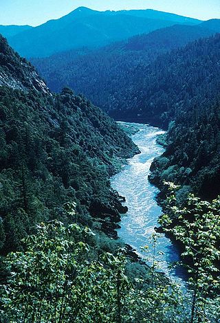
The Klamath River flows 257 miles (414 km) through Oregon and northern California in the United States, emptying into the Pacific Ocean. By average discharge, the Klamath is the second largest river in California after the Sacramento River. Its nearly 16,000-square-mile (41,000 km2) watershed stretches from the high desert of south-central Oregon to the temperate rainforest of the North Coast. Unlike most rivers, the Klamath begins in a desert region and flows through the rugged Cascade Range and Klamath Mountains before reaching the ocean; National Geographic magazine has called the Klamath "a river upside down".

<span class="mw-page-title-main">Alaska Peninsula National Wildlife Refuge</span> United States National Wildlife Refuge in southwestern Alaska

The Alaska Peninsula National Wildlife Refuge is a United States National Wildlife Refuge in southwestern Alaska whose use is regulated as an ecological-protection measure. It stretches along the southern coast of the Alaska Peninsula, between the Becharof National Wildlife Refuge on its east and the end of the peninsula at False Pass in the west. In between, however, it is broken into sections by lands of the Aniakchak National Monument and Izembek National Wildlife Refuge. The refuge is administered from offices in King Salmon, Alaska and was established to conserve Alaska Peninsula brown bears, caribou, moose, marine mammals, shorebirds, other migratory birds and fish, and to comply with treaty obligations.

<span class="mw-page-title-main">Puyallup River</span> River in Washington, United States

The Puyallup River is a river in the U.S. state of Washington. About 45 miles (72 km) long, it is formed by glaciers on the west side of Mount Rainier. It flows generally northwest, emptying into Commencement Bay, part of Puget Sound. The river and its tributaries drain an area of about 948 square miles (2,460 km2) in Pierce County and southern King County.

<span class="mw-page-title-main">Williamson River (Oregon)</span> River in Oregon, United States

The Williamson River of south-central Oregon in the United States is about 100 miles (160 km) long. It drains about 3,000 square miles (7,800 km2) east of the Cascade Range. Together with its principal tributary, the Sprague River, it provides over half the inflow to Upper Klamath Lake, the largest freshwater lake in Oregon. The lake's outlet is the Link River, which flows into Lake Ewauna and the Klamath River.

<span class="mw-page-title-main">Nisqually River</span> River in Washington, United States

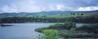
The Nisqually River is a river in west central Washington in the United States, approximately 81 miles (130 km) long. It drains part of the Cascade Range southeast of Tacoma, including the southern slope of Mount Rainier, and empties into the southern end of Puget Sound. Its outlet was designated in 1971 as the Nisqually Delta National Natural Landmark.

<span class="mw-page-title-main">Humboldt Bay</span> Bay on the North Coast of California

Humboldt Bay is a natural bay and a multi-basin, bar-built coastal lagoon located on the rugged North Coast of California, entirely within Humboldt County, United States. It is the largest protected body of water on the West Coast between San Francisco Bay and Puget Sound, the second-largest enclosed bay in California, and the largest port between San Francisco and Coos Bay, Oregon. The largest city adjoining the bay is Eureka, the regional center and county seat of Humboldt County, followed by the city of Arcata. These primary cities, together with adjoining unincorporated communities and several small towns, comprise a Humboldt Bay Area with a total population of nearly 80,000 people. This comprises nearly 60% of the population of Humboldt County. The bay is home to more than 100 plant species, 300 invertebrate species, 100 fish species, and 200 bird species. In addition, the bay and its complex system of marshes and grasses support hundreds of thousands of migrating and local shore birds. Commercially, this second-largest estuary in California is the site of the largest oyster production operations on the West Coast, producing more than half of all oysters farmed in California.

<span class="mw-page-title-main">Lower Suwannee National Wildlife Refuge</span> Refuge on the western coast of Florida, U.S.

The Lower Suwannee National Wildlife Refuge (LSNWR) is part of the United States National Wildlife Refuge System. It is located in southeastern Dixie and northwestern Levy counties on the western coast of Florida, approximately fifty miles southwest of the city of Gainesville.

<span class="mw-page-title-main">Suisun Marsh</span> Largest brackish water marsh on west coast of US

Located in northern California, the Suisun Marsh has been referred to as the largest brackish water marsh on west coast of the United States of America. The marsh land is part of a tidal estuary, and subject to tidal ebb and flood. The marsh is home to many species of birds and other wildlife, and is formed by the confluence of the Sacramento and San Joaquin rivers between Martinez and Suisun City, California and several other smaller, local watersheds. Adjacent to Suisun Bay, the marsh is immediately west of the legally defined Sacramento-San Joaquin Delta as well as part of the San Francisco Bay estuary.

<span class="mw-page-title-main">Malheur National Wildlife Refuge</span> Protected area in eastern Oregon, USA

Malheur National Wildlife Refuge is a National Wildlife Refuge located roughly 30 miles (48 km) south of the city of Burns in Oregon's Harney Basin. Administered by the United States Fish and Wildlife Service, the refuge area is roughly T-shaped with the southernmost base at Frenchglen, the northeast section at Malheur Lake and the northwest section at Harney Lake.

<span class="mw-page-title-main">Ankeny National Wildlife Refuge</span>

Ankeny National Wildlife Refuge is located in the fertile Willamette Valley of northwestern Oregon, 12 miles (19 km) south of Salem. The valley was once a rich mix of wildlife habitats. Valley wetlands were once extensive, with meandering stream channels and vast seasonal marshes. Today, the valley is a mix of farmland and growing cities, with few areas remaining for wildlife.

The Treaty of Medicine Creek was an 1854 treaty between the United States, and nine tribes and bands of Indians, occupying the lands lying around the head of Puget Sound, Washington, and the adjacent inlets. The tribes listed on the Treaty of Medicine Creek are Nisqually, Puyallup, Steilacoom, Squawskin, S'Homamish, Stehchass, T'Peeksin, Squi-aitl, and Sa-heh-wamish. The treaty was signed on December 26, 1854, by Isaac I. Stevens, governor and superintendent of Indian Affairs of the territory at the time of the signing, along with the chiefs, head-men and delegates of the stated tribes. For the purpose of the treaty, these representatives who signed the treaty were stated to have been, "regarded as one nation, on behalf of said tribes and bands, and duly authorized by them."

The Oregon Coast National Wildlife Refuge Complex consists of six National Wildlife Refuges along the Oregon Coast. It provides wilderness protection to thousands of small islands, rocks, reefs, headlands, marshes, and bays totaling 371 acres spanning 320 miles (515 km) of Oregon's coastline. The areas are all managed by the United States Fish and Wildlife Service.

<span class="mw-page-title-main">Bandon Marsh National Wildlife Refuge</span>

Bandon Marsh National Wildlife Refuge is a U.S. National Wildlife Refuge on Oregon's coast. It is one of six National Wildlife Refuges comprising the Oregon Coast National Wildlife Refuge Complex and is renowned among bird watchers for being able to view rare shorebirds including ruff, Hudsonian godwit, and Mongolian plover. The refuge was last expanded in 1999, it now has 889 acres (3.60 km2) in two units: Bandon Marsh and Ni-les'tun.

<span class="mw-page-title-main">San Pablo Bay National Wildlife Refuge</span> Protected area in California, United States

San Pablo Bay National Wildlife Refuge is a 13,190-acre (53.4 km2) National Wildlife Refuge in California established in 1970. It extends along the northern shore of San Pablo Bay, from the mouth of the Petaluma River, to Tolay Creek, Sonoma Creek, and ending at Mare Island.

<span class="mw-page-title-main">Billy Frank Jr.</span> Native American rights activist

Billy Frank Jr. was a Native American environmental leader and advocate of treaty rights. As a member of the Nisqually tribe, Frank led a grassroots campaign in the 1960s and 1970s to secure fishing rights on the Nisqually River, located in Washington state. His efforts centered around promoting cooperative management of natural resources. Frank served as the chairman of the Northwest Indian Fisheries Commission for over thirty years.

<span class="mw-page-title-main">Silvio O. Conte National Fish and Wildlife Refuge</span> Natural conservation area in the northeastern United States

Silvio O. Conte National Fish and Wildlife Refuge was established in 1997 to conserve, protect and enhance the abundance and diversity of native plant, fish and wildlife species and the ecosystems on which they depend throughout the 7,200,000-acre (29,000 km2) Connecticut River watershed. The watershed covers large areas of Vermont, New Hampshire, Massachusetts and Connecticut. It contains a great diversity of habitats, notably: northern forest valuable as nesting habitat for migrant thrushes, warblers and other birds; rivers and streams used by shad, salmon, herring, the endangered shortnose sturgeon and other migratory fishes; and an internationally significant complex of high-quality tidal fresh, brackish and salt marshes.

<span class="mw-page-title-main">Marsh Creek (California)</span> River in California, United States

Marsh Creek is a stream in east Contra Costa County, California in Northern California which rises on the eastern side of Mount Diablo and flows 30 miles (48 km) to the Sacramento–San Joaquin River Delta at Oakley, California, near Big Break Regional Shoreline. The creek flows through Marsh Creek State Park (California), where water is impounded to form Marsh Creek Reservoir, then through the city of Brentwood, California.

The Fish Wars were a series of civil disobedience protests by Native American tribes in the Pacific Northwest region of the United States during the 1960s and 1970s. These protests, coordinated by tribes around the Puget Sound, pressured the U.S. government to recognize fishing rights granted by the Treaty of Medicine Creek. They protested by continuing to fish on their land while risking charges being pressed against them.

<span class="mw-page-title-main">Sitka Sedge State Natural Area</span> Natural area in Tillamook County, Oregon, United States

Sitka Sedge State Natural Area is an estuary and beach on the north coast of the U.S. state of Oregon in Tillamook County. Sitka Sedge consists of 357 acres (144 ha) of tidal marsh, mudflats, dunes, forested wetlands, and uplands at the south end of the Sand Lake estuary, north of Tierra Del Mar.

References

  1. "Nisqually National Wildlife Refuge". Geographic Names Information System . United States Geological Survey, United States Department of the Interior.
  2. "Nisqually National Wildlife Refuge". Geographic Names Information System . United States Geological Survey, United States Department of the Interior.
  3. "Annual Report of Lands as of September 30, 2013" (PDF). United States Fish and Wildlife Service.
  4. "About the Refuge". Nisqually National Wildlife Refuge. U.S. Fish and Wildlife Service.
  5. 1 2 3 4 5 6 7 8 9 Norberg, David (November 23, 2018). "Billy Frank Jr. Nisqually National Wildlife Refuge and the Nisqually River Watershed". HistoryLink. Retrieved April 23, 2024.
  6. "Statement by the Press Secretary on H.J.Res. 76, H.R. 2270, H.R. 2297, H.R. 2693, H.R. 2820, H.R. 3594, H.R. 3831, H.R. 4246, S. 614, S. 808, S. 1090 and S. 1461". whitehouse.gov (Press release). December 18, 2015. Retrieved December 26, 2015 via National Archives.
  7. "Nisqually wildlife refuge to be renamed for activist Billy Frank Jr". The Seattle Times . December 14, 2015. Retrieved December 26, 2015.
  8. Connelly, Joel (December 14, 2015). "Senate passes legislation to rename Nisqually Wildlife Refuge for Billy Frank Jr". Seattle Post-Intelligencer . Retrieved December 26, 2015.
  9. "Billy Frank Jr., Tell Your Story". U.S. Fish and Wildlife Service. Retrieved 2019-03-26.
  10. "Billy Frank Jr. Nisqually National Wildlife Refuge" (PDF).
  11. "Habitat". Nisqually National Reserve. U.S. Fish and Wildlife Service. Retrieved February 25, 2015.
  12. "Fish". Nisqually National Reserve. U.S. Fish and Wildlife Service. Retrieved February 25, 2015.