The Lower Suwannee National Wildlife Refuge (LSNWR) is part of the United States National Wildlife Refuge System. It is located in southeastern Dixie and northwestern Levy counties on the western coast of Florida, approximately fifty miles southwest of the city of Gainesville.
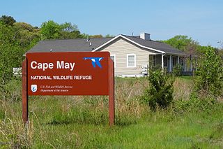
The Cape May National Wildlife Refuge is a protected area on the Cape May Peninsula in Cape May County, New Jersey. It is part of the National Wildlife Refuge System and managed by the United States Fish and Wildlife Service. Established in January 1989 with 90 acres (0.36 km2) acquired from the Nature Conservancy, it has since grown to more than 11,000 acres (45 km2) in size, and plans call for its further expansion to more than 21,200 acres (86 km2). It comprises three distinct and non-contiguous units: the Delaware Bay Division, the Great Cedar Swamp Division and the Two Mile Beach Unit. Located in the Middle Atlantic coastal forests ecoregion, the cape provides habitat for large numbers of migratory birds.

The Rachel Carson National Wildlife Refuge is a 9,125-acre (37 km2) National Wildlife Refuge made up of several parcels of land along 50 miles (80 km) of Maine's southern coast. Created in 1966, it is named for environmentalist and author Rachel Carson, whose book Silent Spring raised public awareness of the effects of DDT on migratory songbirds, and of other environmental issues.
The Oregon Coast National Wildlife Refuge Complex consists of six National Wildlife Refuges along the Oregon Coast. It provides wilderness protection to thousands of small islands, rocks, reefs, headlands, marshes, and bays totaling 371 acres spanning 320 miles (515 km) of Oregon's coastline. The areas are all managed by the United States Fish and Wildlife Service.

Bandon Marsh National Wildlife Refuge is a U.S. National Wildlife Refuge on Oregon's coast. It is one of six National Wildlife Refuges comprising the Oregon Coast National Wildlife Refuge Complex and is renowned among bird watchers for being able to view rare shorebirds including ruff, Hudsonian godwit, and Mongolian plover. The refuge was last expanded in 1999, it now has 889 acres (3.60 km2) in two units: Bandon Marsh and Ni-les'tun.

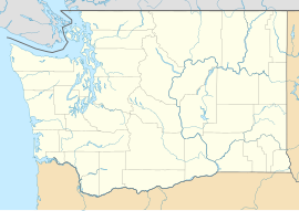
Willapa National Wildlife Refuge is a National Wildlife Refuge located on the shores of Willapa Bay in Washington, United States. It comprises 11,000 acres (45 km2) of sand dunes, sand beaches, mudflats, grasslands, saltwater and freshwater marshes, and coniferous forest. The refuge includes Long Island with stands of old growth Western red cedar and hemlock.

The Chincoteague National Wildlife Refuge is a 14,000-acre (57 km2) wildlife preserve operated by the U.S. Fish & Wildlife Service. It is primarily located on the Virginia half of Assateague Island with portions located on the Maryland side of the island, as well as Morris Island and Wildcat Marsh. The refuge contains a large variety of wildlife animals and birds, including the Chincoteague Pony. The purpose of the refuge is to maintain, regulate and preserve animal and plant species as well as their habitats for present and future generations.
The Delta National Wildlife Refuge is located 10 miles (16 km) east of Venice, Louisiana along the Mississippi River. The area formed when a breach in the natural levee of the Mississippi River occurred in 1862 approximately 100 miles (160 km) below New Orleans, Louisiana. The 48,000-acre (190 km2) refuge was purchased in 1935 with the primary purpose to provide sanctuary and habitat to wintering waterfowl. Access is by boat only.
The San Luis National Wildlife Refuge Complex is located in the northern San Joaquin Valley, within Merced County and Stanislaus County of California. The complex, with four federal National Wildlife Refuges, is managed by the U.S Fish & Wildlife Service.

The Sonny Bono Salton Sea National Wildlife Refuge is located in the Imperial Valley of California, 40 miles (64 km) north of the Mexican border. Situated at the southern end of the Salton Sea, the refuge protects one of the most important nesting sites and stopovers along the Pacific Flyway. Despite its location in the Colorado Desert, a subdivision of the larger Sonoran Desert, the refuge contains marine, freshwater, wetland, and agricultural habitats which provide sanctuary for hundreds of birds and wetland species, including several that have been listed as endangered or sensitive by the U.S. Fish and Wildlife Service.
Kakahaiʻa National Wildlife Refuge (NWR) was established in 1977 to permanently protect wetland habitat for endangered endemic waterbirds and wintering migratory wetland birds and to maintain the structural integrity of an ancient Hawaiian fishpond.

Castle Rock National Wildlife Refuge is 0.5 miles (0.80 km) offshore from Crescent City in northern California. This coastal rock covers approximately 14 acres (57,000 m2), and rises steeply 335 feet (102 m) above sea level. The refuge provides an important sanctuary for the Aleutian cackling goose and nesting seabirds.

Nantucket National Wildlife Refuge is a 24-acre (9.7 ha) range and was established in 1973 for its "particular value in carrying out the national migratory bird management program." The refuge, which is cooperatively managed with The Trustees of Reservations, encompasses 24 acres (9.7 ha) at Great Point. Nantucket National Wildlife Refuge is an un-staffed unit of the Eastern Massachusetts National Wildlife Refuge Complex. Nantucket National Wildlife Refuge consists of the Northeast tip of Nantucket, known as Great Point. The Refuge has been managed informally by TTOR several decades. TTOR owns the land immediately adjacent to Great Point, known as the Coskata-Coatue Wildlife Refuge. Great Point is known as one of the best surfcasting locations in New England because of the rip tide which brings bluefish and striped bass to the point. The Refuge is also a destination for hundreds of visitors each year seeking to enjoy a Nantucket beach or a tour of the Great Point Lighthouse. More information about the adjacent TTOR property is available on their website.

The Supawna Meadows National Wildlife Refuge is a component of the Delaware River estuary in Salem County, New Jersey, it is just north of the Salem River and south of Pennsville.

The Amagansett National Wildlife Refuge, in Amagansett, New York, is located along the shore of the Atlantic Ocean on Long Island's south fork. The refuge is managed by the United States Fish and Wildlife Service as part of the Long Island National Wildlife Refuge Complex.

The Elizabeth A. Morton National Wildlife Refuge is a 187-acre (76 ha) National Wildlife Refuge in Noyack, New York. Much of the refuge is situated on a peninsula surrounded by Noyack and Little Peconic bays. The refuge is managed by the United States Fish and Wildlife Service as part of the Long Island National Wildlife Refuge Complex.
The Target Rock National Wildlife Refuge is located just east of the village of Lloyd Harbor, New York, on the north shore of Long Island, 25 miles (40 km) east of New York City. It is managed by the U.S. Fish and Wildlife Service as part of the Long Island National Wildlife Refuge Complex.
Tybee National Wildlife Refuge was established on May 9, 1938, by an executive order of President Franklin D. Roosevelt, as a breeding area for migratory birds and other wildlife. Located in the mouth of the Savannah River, the 100-acre (0.40 km2) refuge began as a 1-acre (4,000 m2) oyster shoal, Oysterbed Island, used by the U.S. Army Corps of Engineers as a spoil disposal site to support their mandated harbor dredging activity. As a result, the majority of the refuge is now covered with sand deposits. The more stable portions of the island are densely covered with such woody species as eastern red cedar, wax myrtle, and groundsel. saltwater marsh borders parts of the island.
The John H. Chafee National Wildlife Refuge is a national wildlife refuge of the United States, located along the Narrow River on the southern coast of Rhode Island.
Salinas River National Wildlife Refuge is located approximately 11 miles north of Monterey, California, and 3 miles south of Castroville, California, at the point where the Salinas River empties into Monterey Bay. The 367-acre (1.49 km2) refuge encompasses several habitat types including sand dunes, pickleweed salt marsh, river lagoon, riverine habitat, and a saline pond. The refuge was established in 1974 because of its "particular value in carrying out the national migratory bird management program."