
The Missoula floods were cataclysmic glacial lake outburst floods that swept periodically across eastern Washington and down the Columbia River Gorge at the end of the last ice age. These floods were the result of periodic sudden ruptures of the ice dam on the Clark Fork River that created Glacial Lake Missoula. After each ice dam rupture, the waters of the lake would rush down the Clark Fork and the Columbia River, flooding much of eastern Washington and the Willamette Valley in western Oregon. After the lake drained, the ice would reform, creating Glacial Lake Missoula again.

Grand Coulee is an ancient river bed in the U.S. state of Washington. This National Natural Landmark stretches for about 60 miles (100 km) southwest from Grand Coulee Dam to Soap Lake, being bisected by Dry Falls into the Upper and Lower Grand Coulee.

The Channeled Scablands at one time were a relatively barren and soil-free region of interconnected relict and dry flood channels, coulees and cataracts eroded into Palouse loess and the typically flat-lying basalt flows that remain after cataclysmic floods within the southeastern part of the U.S. state of Washington. The Channeled Scablands were scoured by more than 40 cataclysmic floods during the Last Glacial Maximum and innumerable older cataclysmic floods over the last two million years. These floods were periodically unleashed whenever a large glacial lake broke through its ice dam and swept across eastern Washington and down the Columbia River Plateau during the Pleistocene epoch. The last of the cataclysmic floods occurred between 18,200 and 14,000 years ago.

Coulee, or coulée is a term applied rather loosely to different landforms, all of which refer to a kind of valley or drainage zone. The word coulee comes from the Canadian French coulée, from French couler 'to flow'.

J Harlen Bretz was an American geologist, best known for his research that led to the acceptance of the Missoula Floods and for his work on caves.

The Palouse River is a tributary of the Snake River in Washington and Idaho, in the northwest United States. It flows for 167 miles (269 km) southwestwards, primarily through the Palouse region of southeastern Washington. It is part of the Columbia River Basin, as the Snake River is a tributary of the Columbia River.

Dry Falls is a 3.5-mile-long (5.6 km) scalloped precipice with four major alcoves, in central Washington scablands. This cataract complex is on the opposite side of the Upper Grand Coulee from the Columbia River, and at the head of the Lower Grand Coulee, northern end of Lenore Canyon. According to the current geological model, catastrophic flooding channeled water at 65 miles per hour through the Upper Grand Coulee and over this 400-foot (120 m) rock face at the end of the last glaciation. It is estimated that the falls were five times the width of Niagara Falls, with ten times the flow of all the current rivers in the world combined.

Steamboat Rock State Park is a 3,522-acre (1,425 ha) Washington state park located near the north end of Banks Lake in the Grand Coulee. The park takes its name from the landscape's dominating feature, Steamboat Rock, a basalt butte that rises 800 feet (240 m) above the lake which nearly completely surrounds it. The butte's plateau covers more than 600 acres (240 ha) and was used by nomadic Native American tribes and by early settlers. During the last ice age, the monolith stood as an island in the new bed of the Columbia River where it had been diverted by ice dams. Once the dams burst creating massive floods and the Scablands, the Columbia returned to its original course, leaving Steamboat Rock as a prominent feature of the dry Grand Coulee.
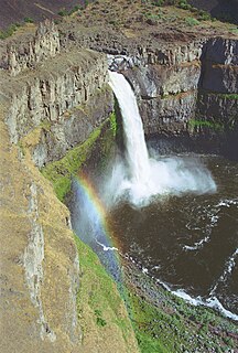
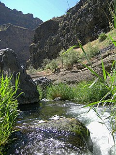
Palouse Falls is a waterfall on the Palouse River, about 4 mi (6 km) upstream of the confluence with the Snake River in southeast Washington, United States. The falls are 200 ft (61 m) in height. The falls consist of an upper fall with a drop around 20 ft (6.1 m), which lies 1,000 ft (305 m) north-northwest of the main drop, and a lower fall, with a drop of 200 ft (61 m). It is in the 94-acre (38 ha) Palouse Falls State Park.
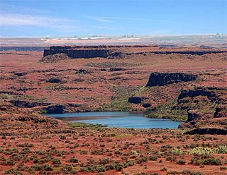
Drumheller Channels National Natural Landmark showcases the Drumheller Channels, which are the most significant example in the Columbia Plateau of basalt butte-and-basin Channeled Scablands. This National Natural Landmark is an extensively eroded landscape, located in south central Washington state characterized by hundreds of isolated, steep-sided hills (buttes) surrounded by a braided network of numerous channels, all but one of which are currently dry. It is a classic example of the tremendous erosive powers of extremely large floods such as those that reformed the Columbia Plateau volcanic terrain during the late Pleistocene glacial Missoula Floods.
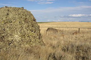
Sims Corner Eskers and Kames National Natural Landmark of Douglas County, Washington and nearby McNeil Canyon Haystack Rocks and Boulder Park natural landmarks contain excellent examples of Pleistocene glacial landforms. Sims Corner Eskers and Kames National Natural Landmark includes classic examples of ice stagnation landforms such as glacial erratics, terminal moraines, eskers, and kames. It is located on the Waterville Plateau of the Columbia Plateau in north central Washington state in the United States.

Moses Coulee is a canyon in the Waterville plateau region of Douglas County, Washington. Moses Coulee is the second-largest and westernmost canyon of the Channeled Scablands, located about 30 kilometres (19 mi) to the west of the larger Grand Coulee. This water channel is now dry, but during glacial periods, large outburst floods with discharges greater than 600,000 m3/s (21,000,000 cu ft/s) carved the channel. While it's clear that megafloods from Glacial Lake Missoula passed through and contributed to the erosion of Moses Coulee, the origins of the coulee are less clear. Some researchers propose that floods from glacial Lake Missoula formed Moses Coulee, while others suggest that subglacial floods from the Okanogan Lobe incised the canyon. The mouth of Moses Coulee discharges into the Columbia River.

Crab Creek is a stream in the U.S. state of Washington. Named for the presence of crayfish, it is one of the few perennial streams in the Columbia Basin of central Washington, flowing from the northeastern Columbia River Plateau, roughly 5 km (3.1 mi) east of Reardan, west-southwest to empty into the Columbia River near the small town of Beverly. Its course exhibits many examples of the erosive powers of extremely large glacial Missoula Floods of the late Pleistocene, which scoured the region. In addition, Crab Creek and its region have been transformed by the large-scale irrigation of the Bureau of Reclamation's Columbia Basin Project (CBP), which has raised water table levels, significantly extending the length of Crab Creek and created new lakes and streams.

The Saddle Mountains consists of an upfolded anticline ridge of basalt in Grant County of central Washington state. The ridge, reaching to 2,700 feet, terminates in the east south of Othello, Washington near the foot of the Drumheller Channels. It continues to the west where it is broken at Sentinel Gap before ending in the foothills of the Cascade Mountains.

The Columbia Plateau Trail is a 130-mile-long (210 km), 20-foot-wide (6.1 m) corridor in eastern Washington state maintained as part of the Washington State Park system. The trail runs along the abandoned right-of-way of the former Spokane, Portland and Seattle Railway from Cheney to the confluence of the Snake and Columbia rivers at Pasco, Washington, passing through five counties in the southeastern part of the state. The trail is mostly gravel, except for a 3.75 mile portion between the Cheney and Fish Lake trailheads. Recreational uses include hiking, mountain biking, horseback riding, in-line skating on paved portions, and wildlife viewing. The close proximity of the railroad to the paved portion makes this section of the trail a popular spot for railfanning.

Lake Lenore is located in Grant County, Washington. It is a 1,670-acre (680 ha) lake formed by the Missoula Floods in the lower Coulee just north of the town of Soap Lake, Washington. It is situated between Alkali Lake to the north and Soap Lake to the south. The lake is rather narrow, but long. The length of the lake runs north–south alongside Washington State Route 17 leading from near the city of Soap Lake to Coulee City, Washington.
The Ice Age Floods National Geologic Trail is a network of routes connecting natural sites and facilities that provide interpretation of the geological consequences of the Glacial Lake Missoula floods of the last glacial period that occurred about 18,000 to 15,000 years ago. It includes sites in Washington, Oregon, Idaho, and Montana. It was designated as the first National Geologic Trail in the United States in 2009.
Glacial Lake Columbia was the lake formed on the ice-dammed Columbia River behind the Okanogan lobe of the Cordilleran Ice Sheet when the lobe covered 500 square miles (1,300 km2) of the Waterville Plateau west of Grand Coulee in central Washington state during the Wisconsin glaciation. Lake Columbia was a substantially larger version of the modern-day lake behind the Grand Coulee Dam. Lake Columbia's overflow – the diverted Columbia River – drained first through Foster Coulee, and as the ice dam grew, through first Moses Coulee, and finally, the Grand Coulee.
Rock Creek is a tributary of the Palouse River in the U.S. state of Washington. The source of the creek is Pine Lakes in the Turnbull National Wildlife Refuge (TNWR). The creek flows through the TNWR and ultimately joins the Palouse River 6 miles (10 km) downstream from the unincorporated town of Winona, Washington.
Douglas Creek is a creek in Douglas County, Washington. It rises in Douglas County, flows through Moses Coulee then empties to Wanapum Lake on the Columbia River. The course of the creek through Moses Coulee displays an "outdoor geologic laboratory" exhibiting basalt formations and relics of the Missoula floods of the last ice age. The watershed of Douglas Creek proper covers 132,056 acres (53,441 ha), about 11% of the county, but including McCarteny Creek the entire Moses Coulee drainage is 1,000 square miles (2,600 km2) or a little more than half of the county. The creek's flow reaches the Columbia River "during storm water runoff events", otherwise being absorbed into the aquifer.


