
Olympic National Forest is a U.S. National Forest located in Washington, USA. With an area of 628,115 acres (2,541.89 km2), it nearly surrounds Olympic National Park and the Olympic Mountain range. Olympic National Forest contains parts of Clallam, Grays Harbor, Jefferson, and Mason counties. The landscape of the national forest varies, from the temperate Olympic rain forest to the salt water fjord of Hood Canal to the peaks of Mt. Washington.

Rothrock State Forest is a Pennsylvania state forest in Pennsylvania Bureau of Forestry District #5. The main offices are located in Huntingdon in Huntingdon County, Pennsylvania in the United States.

Bald Eagle State Forest is a Pennsylvania state forest in Pennsylvania Bureau of Forestry District #7. The main office is located in Laurelton in Union County, Pennsylvania, in the United States. The forest is found in Centre, Clinton, Mifflin, Snyder, and Union Counties. Bald Eagle shares a common border on its western extent with Rothrock State Forest and on its northern extent with Tiadaghton State Forest.

Tiadaghton State Forest is a Pennsylvania State Forest in the Pennsylvania Bureau of Forestry District #12. The forest is chiefly in western and southern Lycoming County, with small portions in Clinton, Potter, Tioga, and Union Counties.

The Minnesota Department of Natural Resources is the agency of the U.S. state of Minnesota charged with conserving and managing the state's natural resources. The agency maintains areas such as state parks, state forests, recreational trails, and recreation areas as well as managing minerals, wildlife, and forestry throughout the state. The agency is divided into six divisions - Ecological & Water Resources, Enforcement, Fish & Wildlife, Forestry, Lands & Minerals, and Parks & Trails.

Poe Paddy State Park is a 23-acre (9.3 ha) Pennsylvania state park in Haines Township, Centre County, Pennsylvania in the United States. The park is surrounded by Bald Eagle State Forest. Poe Valley State Park is 4 miles (6.4 km) to the east. The park is at the confluence of Big Poe Creek and Penns Creek. Poe Paddy State Park is named for the two mountains that surround it. Poe Mountain lies to the east and Paddy Mountain lies to the west, with Penns Creek in the valley between them.

R. B. Winter State Park is a Pennsylvania state park on 695 acres (281 ha) in Hartley Township, Union County, Pennsylvania in the United States. It is in the ridge and valley region of Pennsylvania and is surrounded by Bald Eagle State Forest. R. B. Winter State Park is in a shallow basin that is surrounded by ridges. Halfway Lake is the central recreational focus of the park. The park is 18 miles (29 km) west of Lewisburg on Pennsylvania Route 192.

A dark-sky preserve (DSP) is an area, usually surrounding a park or observatory, that restricts artificial light pollution. The purpose of a dark sky preserve is generally to promote astronomy. Because different national organizations have worked independently to create their programs, different terms have been used to describe the areas. This has led to confusion between the terms reserve, preserve, and park. The International Dark-Sky Association (IDA) chooses reserve to avoid confusion with park, when using the initialisms "IDSR" and "IDSP".

Snyder Middleswarth Natural Area is a 500 acre (202 ha) National Natural Landmark within Bald Eagle State Forest in Spring Township, Snyder County, Pennsylvania in the United States. It is named for two Pennsylvania politicians from Snyder County: Simon Snyder and Ner Alexander Middleswarth. It was formerly a Pennsylvania state park and was the only one in Snyder County, but lost its state park status in the mid 1990s.
The Ohio Department of Natural Resources (ODNR) is the Ohio state government agency charged with ensuring "a balance between wise use and protection of our natural resources for the benefit of all." ODNR regulates the oil and gas industry, the mining industry, hunting and fishing, and dams, while maintaining natural resources such as state parks, state nature preserves, state wildlife areas, state forests, and state waterways. It was created in 1949 by the Ohio Legislature.

Woodard Bay Natural Resources Conservation Area is a natural reserve in Olympia, Washington protected under the Washington Natural Areas Program. Once an important processing facility for the logging industry, it has been designated as the Weyerhaeuser South Bay Log Dump Rural Historic Landscape. Today the area is a renowned sanctuary for a variety of birds, harbor seals, river otters, bald eagles, and a colony of bats, as well as serving as an important great blue heron rookery. A recent conservation program in the area between the State of Washington and the Nature Conservancy is the first of its kind in the country.

New York State Forests are administered by the Division of Lands and Forests of the New York State Department of Environmental Conservation (NYSDEC). New York State Forests include reforestation, multiple use, and unique areas; and state nature and historic preserves, with approximately 600,000 acres (2,400 km2) classified as reforestation areas and approximately 9,000 acres (36 km2) classified as multiple use lands. Land within the Adirondack Park or the Catskill Park is not included as part of the State Forest system.

Mima Mounds Natural Area Preserve is a state-protected Natural Area in southwest Washington state, United States. The preserve includes some of the Washington mima mounds, the origin of which still is not fully understood. The site comprises 637 acres (258 ha) of Garry oak woodland, oak savanna, and prairie grasslands. Several state and federal endangered species of butterfly depending on the unique prairie conditions can be found in the preserve, including Mardon skipper, zerene fritillary, Puget blue and Taylor's checkerspot.
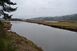
Kennedy Creek Natural Area Preserve is a state-protected Natural Area near US Highway 101 on Oyster Bay, Puget Sound, in southwest Washington state, United States. The preserve is on the border of Thurston County and Mason County and contains 203 acres (82 ha) of intertidal salt marsh and upland forest.

Ink Blot Natural Area Preserve is a Washington state Natural Area Preserve located in Mason County. The preserve totals 153 acres (62 ha), mostly wetlands and Sphagnum bogs in three parallel glacier-formed basins.
The Blue Hills just west of Bremerton, Washington, also called the Bremerton Hills, Bald Hills, and Wildcat Hills, consist of Gold Mountain, Green Mountain, and several informally named hills. Reaching an elevation of 1761 feet, a thousand feet above the glacial till that fills the Puget Lowland, they form a prominent landmark visible around the region. They are formed of uplifted blocks of marine basalts, the steep-walled canyons between the various summits being the fissures between the blocks. In addition to Gold Mountain and Green Mountain are several other prominent peaks unofficially named according to their elevation :

The 2018 Washington wildfire season officially began June 1, 2018. A statewide state of emergency was declared by the Washington State Governor on July 31.
