Big Dry Creek (Westminster, Colorado)

Last updated
Big Dry Creek [1]
Big Dry Creek (Westminster, Colorado).JPG
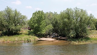
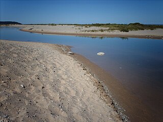
The creek just north of West 120th Avenue.
Location
Physical characteristics
Source 
 - coordinates 39°52′03″N105°13′49″W / 39.86750°N 105.23028°W / 39.86750; -105.23028
Mouth  
 - location
Confluence with the South Platte
 - coordinates
40°04′21″N104°49′37″W / 40.07250°N 104.82694°W / 40.07250; -104.82694 Coordinates: 40°04′21″N104°49′37″W / 40.07250°N 104.82694°W / 40.07250; -104.82694
 - elevation
4,895 ft (1,492 m)
Basin size110 sq mi (280 km2)
Basin features
Progression South PlattePlatte
MissouriMississippi

Big Dry Creek is a tributary that joins the South Platte River near Fort Lupton, Colorado. It rises in Jefferson County, Colorado at the mouth of Coal Creek Canyon at an elevation of 8,000 feet (2,400 m). [2]

Tributary stream or river that flows into a main stem river or lake

A tributary or affluent is a stream or river that flows into a larger stream or main stem river or a lake. A tributary does not flow directly into a sea or ocean. Tributaries and the main stem river drain the surrounding drainage basin of its surface water and groundwater, leading the water out into an ocean.

South Platte River principal tributary of the Platte River

The South Platte River is one of the two principal tributaries of the Platte River. Flowing through the U.S. states of Colorado and Nebraska, it is itself a major river of the American Midwest and the American Southwest/Mountain West. Its drainage basin includes much of the eastern flank of the Rocky Mountains in Colorado; much of the populated region known as the Colorado Front Range and Eastern Plains; and a portion of southeastern Wyoming in the vicinity of the city of Cheyenne. It joins the North Platte River in western Nebraska to form the Platte, which then flows across Nebraska to the Missouri. The river serves as the principal source of water for eastern Colorado. In its valley along the foothills in Colorado, it has permitted agriculture in an area of the Colorado Piedmont and Great Plains that is otherwise arid.

Fort Lupton, Colorado Statutory City in Colorado, United States

The City of Fort Lupton is a Statutory City located in Weld County, Colorado, United States. The population was 6,787 as of the 2000 census.

Contents

The creek flows through Jefferson, Adams, and Weld counties. In Jefferson County, it flows into and out of Standley Lake. It receives treated wastewater from several municipalities, including the City and County of Broomfield, Westminster, Thornton and Northglenn.

Adams County, Colorado County in the United States

Adams County is the fifth-most populous of the 64 counties of the U.S. state of Colorado. As of the 2010 census, the population was 441,603. The county seat is Brighton. The county is named for Alva Adams, Governor of the State of Colorado.

Weld County, Colorado County in the United States

Weld County is one of the 64 counties of the U.S. state of Colorado. As of the 2010 census, the population was 252,825. The county seat is Greeley.

Standley Lake

Standley Lake is a 1,200-acre (4.9 km2) reservoir located in Westminster, Colorado. While originally constructed to provide water for the agricultural irrigation of the surrounding region northwest of Denver, it now serves primarily as the municipal water supply for the cities of Westminster, Northglenn, and Thornton. The lake is also used for recreation, and is the prominent feature of the surrounding 3,000-acre (12 km2) Standley Lake Regional Park.

The Big Dry Creek Watershed Association, a non-profit organization made up of individuals and representatives from local municipalities, monitors the creek's conditions.

A second creek in the Denver Metropolitan Area shares the same name. The other Big Dry Creek rises in Douglas County and joins the South Platte River in Littleton.

Douglas County, Colorado County in the United States

Douglas County is the seventh-most populous of the 64 counties of the U.S. state of Colorado. As of the 2010 census, the population was 285,465. The county seat is Castle Rock.

Littleton, Colorado Home Rule Municipality in Colorado, United States

Littleton is the Home Rule Municipality in Arapahoe, Douglas, and Jefferson counties that is the county seat of Arapahoe County, Colorado, United States. The city is a part of the Denver-Aurora-Lakewood, CO Metropolitan Statistical Area. The city population was 41,737 at the 2010 United States Census, ranking as the 20th most populous municipality in the State of Colorado.

The Big Dry Creek Trail, a recreation trail, roughly follows the creek from Standley Lake Regional Park to Interstate 25. [3]

In the U.S. state of Colorado, Interstate 25 (I-25) follows the north–south corridor through Colorado Springs and Denver. The highway enters the state from the north near Carr and exits the state near Starkville. The highway also runs through the cities of Fort Collins, Loveland, and Pueblo. The route is concurrent with U.S. Highway 87 through the entire length of the state. I-25 replaced U.S. Highway 87 and most of U.S. Highway 85 for through traffic.

See also

Big Dry Creek (Littleton, Colorado) river in the United States of America

Big Dry Creek is a 16.9-mile-long (27.2 km) tributary that joins the South Platte River in Englewood, Colorado. The creek's source is in Daniels Park in Douglas County.

Related Research Articles

Jefferson County, Colorado County in the United States

Jefferson County (Jeffco) is one of the 64 counties in the U.S. state of Colorado. As of the 2010 census, the population was 534,543, making it the fourth-most populous county in Colorado. The county seat is Golden, and the most populous city is Lakewood.

Arapahoe County, Colorado County in the United States

Arapahoe County is one of the 64 counties in the U.S. state of Colorado. As of the 2010 census, the population was 572,003, making it the third-most populous county in Colorado. The county seat is Littleton, and the most populous city is Aurora. The county was named for the Arapaho Native American tribe who once lived in the region.

Westminster, Colorado City in Colorado, United States

Westminster is a Home Rule Municipality in Adams and Jefferson counties in the U.S. state of Colorado. Westminster is a northwest suburb of Denver. The Westminster Municipal Center is located 9 miles (14 km) north-northwest of the Colorado State Capitol. As of the 2010 census the population of Westminster was 106,114, and as of 2016 the estimated population was 113,875. Westminster is the seventh most populous city in Colorado and the 237th most populous city in the United States. Westminster is a part of the Denver-Aurora-Lakewood, CO Metropolitan Statistical Area and the Denver-Aurora-Boulder Combined Statistical Area. In July 2006, it was ranked as the 24th best place to live in the USA by Money magazine.

Englewood, Colorado Home Rule Municipality in Colorado, United States

The City of Englewood is a Home Rule Municipality located in Arapahoe County, Colorado, United States. As of 2010, the population was 30,255. Englewood is part of the Denver-Aurora Metropolitan Area. Englewood is located in the South Platte River Valley east of the Front Range and immediately south of central Denver. Downtown is located immediately east of the confluence of Little Dry Creek and the South Platte River, between Santa Fe Drive and Broadway.

North Platte River major tributary of the Platte River

The North Platte River is a major tributary of the Platte River and is approximately 716 miles (1,152 km) long, counting its many curves. In a straight line, it travels about 550 miles (890 km), along its course through the U.S. states of Colorado, Wyoming, and Nebraska.

River Rouge (Michigan) river in Michigan

The River Rouge is a 127-mile river in the Metro Detroit area of southeastern Michigan. It flows into the Detroit River at Zug Island, which is the boundary between the cities of River Rouge and Detroit.

North Fork South Platte River river in the United States of America

The North Fork South Platte River is a tributary of the South Platte River, approximately 50 miles (80 km) long, in central Colorado in the United States. The river is located near the headwaters of the South Platte in the Rocky Mountains southwest of Denver, draining a rugged area of the Front Range just south of the basin of Clear Creek.

Little Dry Creek (Arapahoe County, Colorado) tributary of the South Platte River in Arapahoe County, Colorado in the United States

Little Dry Creek is a short tributary of the South Platte River, approximately 10 miles (16 km) long, in Arapahoe County, Colorado in the United States. The creek drains a suburban area south of Denver. It rises in Centennial, Arapahoe County, west of I-25, and flows generally northwest into Englewood. It has historically been used for irrigation and feeds an aqueduct that runs parallel to it. The creek flows into South Platte just south of West Dartmouth Avenue approximately two tenths of a mile west of its intersection with Santa Fe Drive which is US 85.

Seneca Creek (Potomac River tributary) tributary of the Potomac River in Maryland, United States

Seneca Creek is a 5.8-mile-long (9.3 km) stream in Montgomery County, Maryland, USA, roughly 16 miles (26 km) northwest of Washington, D.C. It drains into the Potomac River.

Platte River (Michigan) river in Michigan

The Platte River is located in the northern part of the Lower Peninsula of Michigan. Its mouth is located in Sleeping Bear Dunes National Lakeshore and much of the rest is in the Pere Marquette State Forest.

Boulder Creek (Colorado) river in the United States of America

Boulder Creek is a 31.4-mile-long (50.5 km) creek draining the Rocky Mountains to the west of Boulder, Colorado, as well as the city itself and surrounding plains.

Wahweap Creek river in the United States of America

Wahweap Creek is a 55.6-mile (89.5 km) long intermittent stream in southern Utah in the United States, and is a tributary of the Colorado River. It drains a rugged, high elevation, largely roadless mesa and canyon country in the Colorado Plateau region. The creek flows into the Lake Powell reservoir at Wahweap Bay where it gives its name to the Wahweap Marina, a popular access point to the Glen Canyon National Recreation Area.

References

  1. "Big Dry Creek". Geographic Names Information System . United States Geological Survey . Retrieved 2014-06-14.
  2. Wright Water Engineers, Inc. Big Dry Creek Watershed Management Plan, July, 2002. Accessed 2014-06-14
  3. Westminster, Colorado. Big Dry Creek Trail. Accessed 2014-06-15.