Riddlesden is a suburb of Keighley in the county of West Yorkshire, England and on the Leeds and Liverpool Canal.

Wilsden is a village and civil parish in west Bradford, in West Yorkshire, England. Wilsden is 6 miles (9.7 km) west of Bradford and is close to the Aire Valley and the nearby villages of Denholme, Cullingworth, Harden, Cottingley and Allerton. Wilsden re-acquired civil parish status in 2004. The 2001 census revealed a population of 3,697, increasing to 4,807 at the 2011 Census.
Holywell is a market town and community in Flintshire, Wales. It lies to the west of the estuary of the River Dee. The community includes Greenfield.

The City of Bradford is a local government district of West Yorkshire, England, with the status of a city and metropolitan borough. It is named after its largest settlement, Bradford, but covers a large area which includes the towns and villages of Keighley, Shipley, Bingley, Ilkley, Haworth, Silsden, Queensbury, Thornton and Denholme. Bradford has a population of 528,155, making it the fourth-most populous metropolitan district and the sixth-most populous local authority district in England. It forms part of the West Yorkshire Urban Area conurbation which in 2011 had a population of 1,777,934, and the city is part of the Leeds-Bradford Larger Urban Zone (LUZ), which, with a population of 2,393,300, is the fourth largest in the United Kingdom after London, Birmingham and Manchester.

A civil parish is a subnational entity, forming the lowest unit of local government in England. There are 101 civil parishes in the ceremonial county of West Yorkshire, most of the county being unparished. At the 2001 census, there were 557,369 people living in the parishes, accounting for 26.8 per cent of the county's population.

A civil parish is a country subdivision, forming the lowest unit of local government in England. There are 94 civil parishes in the ceremonial county of South Yorkshire, most of the county being unparished. At the 2001 census, there were 360,191 people living in the parishes, increasing to 369,220 in 2011, accounting for 27.5 per cent of the county's population.

Cullingworth is a village and civil parish in the City of Bradford, West Yorkshire, England. Within the boundaries of the historic West Riding of Yorkshire, it is 7 miles (11 km) west of Bradford and 3 miles (5 km) south of Keighley. The surrounding countryside is mainly used for sheep and cattle farming, with areas of moorland lying to the north and west.

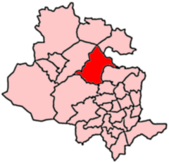
Heaton is a ward within the City of Bradford Metropolitan District Council, West Yorkshire, England. The population at the 2001 census was 16,913, which had increased to 17,121 at the 2011 Census. Historically part of the West Riding of Yorkshire, the ward includes the villages of Frizinghall, Heaton and Daisy Hill, extending to Chellow Heights Reservoir on the western edge and the Bradford-Shipley railway line on the eastern edge. Frizinghall railway station is on the edge of the ward.

Royds is a ward within the City of Bradford Metropolitan District Council in the county of West Yorkshire, England. The population at the 2011 Census was 17,360.
Cottingley is a suburban village within the City of Bradford in West Yorkshire, England between Shipley and Bingley. It is known for the Cottingley Fairies, which appeared in a series of photographs taken there during the early 20th century.
Puddington is a village and civil parish on the Wirral Peninsula, in the unitary authority of Cheshire West and Chester and the ceremonial county of Cheshire, England. It is located to the south east of the town of Neston and close to the border with Wales.

Greater Eston is an unparished area in the Borough of Redcar and Cleveland, North Yorkshire, England. The name is used by the borough's council to describe the centres of Eston, Grangetown, Normanby, Ormesby, South Bank and Teesville.

Waddington is a small village, 2 miles (3 km) north-west of Clitheroe in the Ribble Valley, Lancashire, England. The population of the civil parish at the 2011 census was 1,028. Before the 1974 county boundary changes, Waddington fell just within the Bowland Rural District of the West Riding of Yorkshire. It covers approximately 2000 acres of the Forest of Bowland.
Wiswell is a small village and civil parish in the Ribble Valley, Lancashire, England, close to Whalley and Clitheroe at the foot of Wiswell Moor.
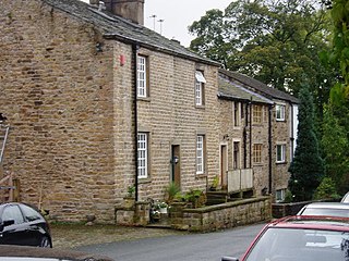
Harden is a civil parish and village within the City of Bradford Metropolitan District, West Yorkshire, England, 2 miles (3.2 km) west of Bingley. It had a population of 1,615 in the 2001 census, but by 2011 this had risen to 1,900.

Hambleton is a small village and civil parish near to Selby in North Yorkshire, England. It is a ward of the Selby District and should not be confused with the Hambleton District, another district of North Yorkshire.

Micklethwaite is a village near to Bingley in West Yorkshire, England. The village is separated from Bingley end of Crossflatts by the Leeds and Liverpool Canal. It is part of Bingley Ward, and population statistics are accounted for in the ward censuses.

Bradford, England is an ethnically and culturally diverse city. The City of Bradford metropolitan borough is the sixth most populous local authority district in the United Kingdom, and includes not only Bradford but also the towns and villages of Keighley, Shipley, Bingley, Ilkley, Haworth, Silsden, Queensbury, Thornton and Denholme.