Tourism in France directly contributed 79.8 billion euros to gross domestic product (GDP) in 2013, 30% of which comes from international visitors and 70% from domestic tourism spending. The total contribution of travel and tourism represents 9.7% of GDP and supports 2.9 million jobs in the country. Tourism contributes significantly to the balance of payments.

A transboundary protected area (TBPA) is an ecological protected area that spans boundaries of more than one country or sub-national entity. Such areas are also known as transfrontier conservation areas (TFCAs) or peace parks.
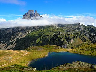
Pyrénées National Park is a French national park located within the departments of Hautes-Pyrénées and Pyrénées-Atlantiques. The park is located along the border of France and Spain along the Pyrenees Mountains, with a scenic landscape offering a variety of outdoor activities including hiking, skiing, mountain climbing and observing wildlife.

Virunga National Park is a national park in the Albertine Rift Valley in the eastern part of the Democratic Republic of the Congo. It was created in 1925. In elevation, it ranges from 680 m (2,230 ft) in the Semliki River valley to 5,109 m (16,762 ft) in the Rwenzori Mountains. From north to south it extends approximately 300 km (190 mi), largely along the international borders with Uganda and Rwanda in the east. It covers an area of 8,090 km2 (3,120 sq mi).

Taï National Park is a national park in Côte d'Ivoire that contains one of the last areas of primary rainforest in West Africa. It was inscribed as a World Heritage Site in 1982 due to the diversity of its flora and fauna. Five mammal species of the Taï National Park are on the Red List of Threatened Species: pygmy hippopotamus, olive colobus monkeys, leopards, chimpanzees, and Jentink's duiker.
The W National Park or W Regional Park is a major national park in West Africa around a meander in the Niger River shaped like the letter W. The park includes areas of the three countries Niger, Benin and Burkina Faso, and is governed by the three governments. Until 2008, the implementation of a regional management was supported by the EU-funded project ECOPAS. The three national parks operate under the name W Transborder Park. The section of W National Park lying in Benin, measuring over 8,000 km2 (3,100 sq mi), came under the full management of African Parks in June 2020. In Benin, W National Park is contiguous with Pendjari National Park which is also under the management of African Parks.

The Niokolo-Koba National Park is a World Heritage Site and natural protected area in south eastern Senegal near the Guinea border. It is served by Niokolo-Koba Airport, an unpaved airstrip.

Lastoursville or Mandji is a city in east-central Gabon, lying on the Ogooué River, the Trans-Gabon Railway and the N3 road. It was founded as a slave depot named Mandji, renamed Maadiville in 1883 and finally took its current name for François Rigail de Lastours in 1886. It grew around palm oil production and as an administrative centre, and soon became a major missionary centre. The town is also known for its caves.

Cultural landscape is a term used in the fields of geography, ecology, and heritage studies, to describe a symbiosis of human activity and environment. As defined by the World Heritage Committee, it is the "cultural properties [that] represent the combined works of nature and of man" and falls into three main categories:
- "a landscape designed and created intentionally by man"
- an "organically evolved landscape" which may be a "relict landscape" or a "continuing landscape"
- an "associative cultural landscape" which may be valued because of the "religious, artistic or cultural associations of the natural element."
Batéké Plateau National Park is a national park on the Bateke Plateau, southeastern Gabon covering 2,034 km2 (785 sq mi). Due to its purported universal cultural and natural significance, it was added onto the UNESCO World Heritage Tentative List on October 20, 2005.

Manovo-Gounda St. Floris National Park is a national park and UNESCO World Heritage Site located in the Central African Republic prefecture Bamingui-Bangoran, near the Chad border. It was inscribed to the list of World Heritage Sites in 1988 as a result of the diversity of life present within it.
This list of national parks of Madagascar includes all officially recognized protected areas as of 2015. The protected areas network of Madagascar is managed by the Madagascar National Parks Association (PNM-ANGAP). The network includes three types of protected areas: Strict Nature Reserves, National Parks and Wildlife Reserves. At the 2003 IUCN World Parks Congress in Durban, the Malagasy President, Marc Ravalomanana, announced an initiative to more than triple the area under protection from approximately 4,200,791 acres (17,000.00 km2) to over 14,826,322 acres (60,000.00 km2). This "Durban Vision", as it has been dubbed, involved broadening the definition of protected areas in the country and legislation has been passed to allow the creation of four new categories of protected area: Natural Parks, Natural Monuments, Protected Landscapes, and Natural Resource Reserves. As well as allowing these new objectives for protected areas management, the new legislation also provided for entities other than PNM-ANGAP to manage protected areas, such as government ministries, community associations, NGOs and other civil society organizations, and the private sector.

Îles Ehotilé National Park is a national park of the Ivory Coast in the Sud-Comoé region. The park consists of a group of low islands and the intervening channels that separate Aby Lagoon from the Atlantic Ocean.

Saloum Delta National Park or Parc National du Delta du Saloum in Senegal, is a 760-square-kilometre (190,000-acre) national park. Established in 1976, it is situated within the Saloum Delta at the juncture of the Saloum River and the North Atlantic.
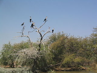
The Djoudj National Bird Sanctuary lies on the southeast bank of the Senegal River in Senegal, in northern Biffeche, north east of St-Louis.

Khenifiss National Park is a national park in the southwest of Morocco, located near Akhfenir on the Atlantic coast in the region of Laâyoune-Sakia El Hamra. It was established in 2006. The area of the park is 1,850 square kilometres (710 sq mi). The national park was created to protect desert, wetlands, and coastal dunes.
Biosphere reserves are areas comprising terrestrial, marine and coastal ecosystems. The biosphere reserve title is handed over by UNESCO. Each reserve promotes solutions reconciling the conservation of biodiversity with its sustainable use. Biosphere reserves are 'Science for Sustainability support sites' – special places for testing interdisciplinary approaches to understanding and managing changes and interactions between social and ecological systems, including conflict prevention and management of biodiversity. Biosphere reserves are nominated by national governments and remain under the sovereign jurisdiction of the states where they are located. Their status is internationally recognized.