There are 13 national parks in Gabon, all created in 2002 when President Omar Bongo established Gabon's National Agency for National Parks (French : Agence Nationale des Parcs Nationaux, ANPN). [1] The national parks cover 10% of the country. [2]
There are 13 national parks in Gabon, all created in 2002 when President Omar Bongo established Gabon's National Agency for National Parks (French : Agence Nationale des Parcs Nationaux, ANPN). [1] The national parks cover 10% of the country. [2]
| Name | Area |
|---|---|
| Akanda National Park | 540 km2 (210 sq mi) |
| Batéké Plateau National Park | 2,034 km2 (785 sq mi) |
| Birougou National Park | 690 km2 (270 sq mi) |
| Crystal Mountains National Park | 1,200 km2 (460 sq mi) |
| Ivindo National Park | 3,000 km2 (1,200 sq mi) |
| Loango National Park | 1,550 km2 (600 sq mi) |
| Lopé National Park | 4,910 km2 (1,900 sq mi) |
| Mayumba National Park | 870 km2 (340 sq mi) |
| Minkébé National Park | 7,570 km2 (2,920 sq mi) |
| Moukalaba-Doudou National Park | 4,500 km2 (1,700 sq mi) |
| Mwangné National Park | 1,160 km2 (450 sq mi) |
| Pongara National Park | 929 km2 (359 sq mi) |
| Waka National Park | 1,060 km2 (410 sq mi) |

Mahajanga was a former province of Madagascar that had an area of 150,023 km2. It had a population of 1,896,000 (2004). Its capital was Mahajanga, the second largest city in Madagascar.
Ogooué-Ivindo Province is the northeasternmost of Gabon's nine provinces, though its Lopé Department is in the very center of the country. It gets its name from two rivers, the Ogooué and the Ivindo. This province, containing thousands of square kilometres of rainforest, is the largest and most sparsely populated and much less developed than the rest of the country. As of 2013 it had a population of 63,293 people. The principal town is Makokou.
Lébamba is a small town in south-western Gabon. It is the capital of Louetsi-Wano Department in Ngounié Province. It lies along the N6 road, 38.3 kilometres northeast of Ndendé. A Catholic Mission has long been established in Lébamba.

Ambam is a town and commune in South Province of Cameroon on the border with Equatorial Guinea and Gabon. This frontier town is located approximately 220 km from Yaoundé and as of 2005 had a population of 1,596. Traditionally, it has traded with its neighbouring countries across the border. The Fang are the main ethnic group.
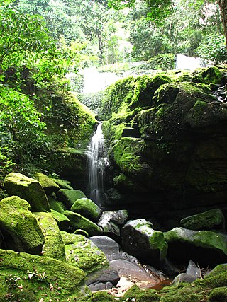
Ivindo National Park is a national park in east-central Gabon in Central Africa, straddling the border of the Ogooué-Ivindo and Ogooué-Lolo provinces. Its creation was announced in August 2002 by then-President Omar Bongo at the Earth Summit in Johannesburg, along with Gabon's 12 other terrestrial national parks. Most famous for the spectacular Kongou and Mingouli waterfalls of the Ivindo River, known as the “wonders of Ivindo”, the park also includes the Ipassa Makokou Biosphere Reserve and Langoué Baï, one of the 5 most important forest clearings in Central Africa. The park was designated as a UNESCO UNESCO World Heritage Site in 2021 for its outstanding biodiversity and relatively intact tropical forest ecosystem.

The Tsimihety are a Malagasy ethnic group who are found in the north-central region of Madagascar. Their name means "those who never cut their hair", a behavior likely linked to their independence from Sakalava kingdom, located to their west, where cutting hair at the time of mourning was expected. They are found in mountainous part of the island. They are one of the largest Malagasy ethnic groups and their population estimates range between 700,000 and over 1.2 million. This estimation places them as the fourth-largest ethnicity in Madagascar.

The Ngounié River is a river flowing through southwest-central Gabon. It is the last and second most important tributary of the Ogooué River, the first being the Ivindo River. It initially flows down from the Chaillu Mountains, along the border with Congo, and then turns northwest, flowing through the towns of Fougamou, Sindara and Mouila before flowing into the Ogooué.
The wildlife of Gabon is composed of its flora and fauna. Gabon is a largely low-lying country with a warm, humid climate. Much of the country is still covered by tropical rainforest and there are also grasslands, savannas, large rivers and coastal lagoons.
The N5 road is one of the national highways of Gabon. It is connects Kougouleu to Médouneu to Bibasse.
Mbigou is a town in southern Gabon. It is the principal town in the Boumi-Louetsi Department in Ngounié Province, about 84 kilometres from Ndendé. It is served by Mbigou Airport.
Fougamou is a small town in Ngounié Province in Gabon. It has a population of about 4,100 and is the capital of Tsamba-Magotsi Department. It lies along the west bank of the Ngounié River on the N1 road between Lambaréné and Mouila.
Bitam is a town in northern Gabon on the N2 road on the border with Cameroon. As of the 2013 census, its population is 27,923.

The Rosario Islands, also referred to as Corales Islas del Rosario, is an archipelago located off the coast of Colombia, approximately 20 kilometres from Cartagena. It is one of the 46 Natural National Parks of Colombia. The national park was founded in 1988, to protect one of the most important coral reefs of the Colombian Caribbean coast. People can visit the national park area of the islands, and tours are available. Isla Rosario has an aquarium and open-sea oceanarium (oceanario) that people can visit. Activities include swimming, snorkeling and fishing, among others.

The Mitsogo or Tsogo are an ethno-cultural group from the highlands of Gabon. They reside mainly in Ngounié Province to the north and east of Mouila. Numbering around 13,000, they speak the Tsogo language. In the late 19th and early 20th century they were known for their fierce resistance to the French.

The Mahajamba is a river of northern Madagascar. It flows through Ankarafantsika National Park. The river is surrounded in mangroves.
The Bakoya are pygmies, earlier known as Négrilles or Babinga, who inhabitant the rainforest between Cameroon and the Great Lake region of the Congo Basin in Central Africa. Since the 1930s, the Bakoya, in particular, have settled in Gabon in the Ogooue-Ivindo Province, in the northeastern region of the country. Similar minority groups are the Babongo and the Baka pygmies. Before they adapted to the agricultural practices in the new settlements in Gabon along the flanks of the road, Bakoya were “semi-nomadic hunter-gatherers” like the other forest-dwelling pygmies; they resided in small huts. The word 'Pygmee' is a French coinage, adopted by the Gabonese. They are the earliest inhabitants of the forest and are nomadic hunter gatherers.
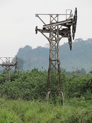
The Compagnie minière de l'Ogooué, or COMILOG, is a manganese mining and processing company based in Moanda, Gabon. It is a subsidiary of the French metallurgical group Eramet. The company is the world's second largest producer of manganese ore. At first the ore was carried by a cableway to the border with the Republic of the Congo, then by rail to the sea at Pointe-Noire. In the 1980s a railway was built to carry the ore through Gabon to the sea near Libreville.
The cinema of Gabon has had an uneven history. Though President Omar Bongo and his wife, Josephine Bongo, encouraged filmmaking in the 1970s, there was a 20-year hiatus until filmmaking started to grow again in the new millennium.

The Serasa Ferry Terminal, also known as Serasa Muara Terminal and Serasa Terminal, is a passenger terminal operated by the Department of Immigration and National Registration in Mukim Serasa, Brunei-Muara District, Brunei. It is one of the two ferry terminals in Brunei, which is located in Kuala Belait Port and Serasa.
{{cite book}}: |author= has generic name (help)