

This is a list of national parks in Namibia , operated by the Ministry of Environment and Tourism.
This is a list of national parks in Namibia , operated by the Ministry of Environment and Tourism.
The protected areas of South Africa include national parks and marine protected areas managed by the national government, public nature reserves managed by provincial and local governments, and private nature reserves managed by private landowners. Most protected areas are intended for the conservation of flora and fauna. National parks are maintained by South African National Parks (SANParks). A number of national parks have been incorporated in transfrontier conservation areas.

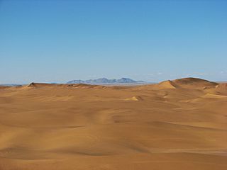
The Namib-Naukluft Park is a national park in western Namibia, situated between the coast of the Atlantic Ocean and the edge of the Great Escarpment. It encompasses part of the Namib Desert, the Naukluft mountain range, and the lagoon at Sandwich Harbour. The best known area of the park and one of the main visitor attractions in Namibia is Sossusvlei, a clay pan surrounded by sand dunes, and Sesriem, a small canyon of the Tsauchab.

A transboundary protected area (TBPA) is an ecological protected area that spans boundaries of more than one country or sub-national entity. Such areas are also known as transfrontier conservation areas (TFCAs) or peace parks.

Namaqualand is an arid region of Namibia and South Africa, extending along the west coast over 1,000 kilometres (600 mi) and covering a total area of 440,000 square kilometres (170,000 sq mi). It is divided by the lower course of the Orange River into two portions – Little Namaqualand to the south and Great Namaqualand to the north.
Iona National Park is the largest national park in Angola. It is situated in the Southwestern corner of the country, in Namibe Province. It is roughly bound by the Atlantic Ocean to the West, an escarpment to the East that marks the beginning of the interior plateau, the Curoca River to the North, and the Cunene River to the South. It is about 200 kilometres (120 mi) south of the city of Namibe and covers 5,850 square miles (15,200 km2) sq. miles.

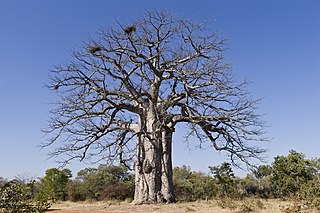
The Richtersveld is a desert landscape characterised by rugged kloofs and high mountains, situated in the north-western corner of South Africa’s Northern Cape province. It is full of changing scenery from flat, sandy, coastal plains, to craggy sharp mountains of volcanic rock and the lushness of the Orange River, which forms the border with neighboring Namibia. The area ranges in altitude from sea level, to 1,377 m (4,518 ft) at Cornellberg. Located in the north-eastern side of the Northern Cape province in South Africa, the Richtersveld is regarded as the only arid biodiversity hotspot on earth and the majority of the area is inscribed on UNESCO's World Heritage List due to its cultural values.

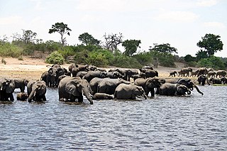
The wildlife of Namibia is composed of its flora and fauna. Namibia's endangered species include wild dog, black rhino, oribi and puku.
South African National Parks (SANParks) is the body responsible for managing South Africa's national parks. SANParks was formed in 1926, and currently manages 19 parks consisting of 3,751,113 hectares (37,511.13 km2), over 3% of the total area of South Africa.

ǀAi-ǀAis is a Namibian holiday resort with hot mineral springs in the bed of the Fish River. It is situated in Southern Namibia's ǁKaras Region at the base of the Great Karas Mountains, 128 kilometres (80 mi) west of Karasburg and 224 kilometres (139 mi) south-west of Keetmanshoop.

The ǀAi-ǀAis/Richtersveld Transfrontier Park is a peace park straddling the border between South Africa and Namibia. It was formed in 2003 by combining the Namibian ǀAi-ǀAis Hot Springs Game Park and the South African Richtersveld National Park. Most of the South African part of the park forms part of the buffer zone of the Richtersveld Cultural and Botanical Landscape World Heritage Site, which measures 5,920 square kilometres (2,290 sq mi). The Fish River Canyon is located in the park, the largest canyon in Africa. A Memorandum of Understanding was signed on 17 August 2003 by the presidents of South Africa and Namibia, which formalized the establishment of the park.
Skeleton Coast National Park is a national park located in northwest Namibia, and has the most inaccessible shores, dotted with shipwrecks. The park was established in 1971 and has a size of 16,845 km2 (6,504 sq mi). The park is divided into a northern and southern section, the southern section is open to those with 4 wheel drive vehicles, they are allowed to go up (north) as far as the Ugab River Gate. The northern section can only be reached by a fly-in safari, and the area is off-limits to all vehicles.
The Iona–Skeleton Coast Transfrontier Conservation Area is a proposed transfrontier conservation area for which four areas are being considered as components.
Kavango–Zambezi Transfrontier Conservation Area (KAZA) is situated in a region of Southern Africa where the international borders of five countries converge. It includes a major part of the Upper Zambezi River and Okavango basins and Delta, the Caprivi Strip of Namibia, the southeastern part of Angola, southwestern Zambia, the northern wildlands of Botswana and western Zimbabwe. The centre of this area is at the confluence of the Zambezi Chobe Rivers where the borders of Botswana, Namibia, Zambia and Zimbabwe meet. It incorporates Chobe National Park, Hwange National Park, and the Victoria Falls.
Richtersveld is an administrative area in the Namakwa District of Northern Cape in South Africa.

Bwabwata National Park is a protected area in northeastern Namibia that was established in 2007 and covers 6,274 km2 (2,422 sq mi). It was created by merging Caprivi Game Park and Mahango Game Reserve. It is situated in the Zambezi and Kavango East regions, extending along the Caprivi Strip. It is bounded by the Okavango River to the west and the Kwando River to the east. Angola lies to the north and Botswana to the south.
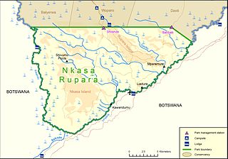
Nkasa Rupara National Park, also Nkasa Lupala National Park, formerly Mamili National Park, is a national park in Namibia. It is centered on the Nkasa and Rupara islands on the Kwando/Linyanti River in the south-western corner of East Caprivi. Botswana lies to the west, south and east, and Sangwali village to the north. It is Namibia's largest formally protected wetland area. It is one of Namibia’s protected areas that benefits local communities surrounding parks. The unfenced park forms a trans-boundary link for wildlife migration between Angola, Botswana, Namibia and Zambia. Nkasa Rupara is part of the Kavango Zambezi Transfrontier Conservation Area.

The protected areas of Namibia include its national parks and reserves. With the 2010 declaration of Dorob National Park, Namibia became the first and only country to have its entire coastline protected through a national parks network. Protected areas are subdivided into game reserves and/or nature reserves, such as special protected area, wilderness areas, natural areas, and development areas. There are also recreation reserves. Facilities in the national parks are operated by Namibia Wildlife Resorts. Over 19% of Namibia is protected, an area of some 130,000 square kilometres. However, the Ministry of Environment & Tourism auctions limited hunting rights within its protected areas. The Namibia Nature Foundation, an NGO, was established in 1987 to raise and administer funds for the conservation of wildlife and protected area management. Communal Wildlife Conservancies in Namibia help promote sustainable natural resource management by giving local communities rights to wildlife management and tourism.
Dorob National Park is a protected area in Erongo, along the central Namibian coast, which is 1,600 kilometres (990 mi) in length. It was gazetted as a national park under the Nature Conservation Ordinance No.4 of 1975 on 1 December 2010, and with Namib-Naukluft Park covers an area of 107,540 square kilometres (41,520 sq mi).
The Damara horseshoe bat, Rhinolophus damarensis, is a species of bat found in Africa.
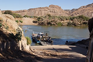
Sendelingsdrift is a border post between Namibia and South Africa in the Richtersveld. A ferry carries traffic across the Orange River at 150 rands per vehicle. The post is usually open from 8:00 AM to 4:00 PM. It also serves as an entrance to the ǀAi-ǀAis/Richtersveld Transfrontier Park, formerly known as Richtersveld National Park. Cellphone reception is limited in the area.