Nkasa Rupara National Park

Last updated
Nkasa Rupara National Park
Map Nkasa Rupara National Park.jpg
Nkasa Rupara (formerly: Mamili) National Park
Namibia relief location map.jpg
Red pog.svg
Location Namibia
Coordinates 18°24′S23°39′E / 18.40°S 23.65°E / -18.40; 23.65
Area320 km2 (120 sq mi)
Established1990

Nkasa Rupara National Park, also Nkasa Lupala National Park, formerly Mamili National Park, is a national park in Namibia. It is centered on the Nkasa and Rupara islands on the Kwando/Linyanti River in the south-western corner of East Caprivi. Botswana lies to the west, south and east, and Sangwali village to the north. It is Namibia's largest formally protected wetland area. [1] It is one of Namibia’s protected areas that benefits local communities surrounding parks. The unfenced park forms a trans-boundary link for wildlife migration between Angola, Botswana, Namibia and Zambia. [2] Nkasa Rupara is part of the Kavango Zambezi Transfrontier Conservation Area (KaZa TFCA). [1]

Contents

History

Mamili National Park was officially proclaimed along with the nearby Mudumu National Park on 1 March 1990. [2] In 2012, the Namibian Government renamed the area as Nkasa Rupara National Park.

The former name, Mamili, referred to a family of traditional leaders of the Mafwe tribe with that surname. The new name, Nkasa Lupala, is a reference to two Kwando River islands within the park's territory. [3]

Geography and access

The Kwando River runs along Nkasa Rupara’s western border and then changes course to become the Linyanti River, forming the park’s south-eastern boundary. It is the same river but is known by different names in various areas. The northern border abuts the Balyewa, Wuparo and Dzoti communal area conservancies The entire area is flat. Most of the park consists of channels of reed beds, lagoons and islands. [1] Nkasa Rupara has relatively narrow, permanently filled main channels of the Kwando/Linyanti River and several periodically flooded channels. The river has its catchment area in Angola and flooding regimes vary considerably. This results in flooding in some years and dry spells during others. [1] To access Nkasa Rupara National Park turn off the B8 Trans-Caprivi Highway, onto the D3511 after the Kongola Bridge. The only entrance track crosses a bridge over a back-channel of the Kwando/Linyanti River, near Sangwali village in Wuparo Conservancy. [4] Rupara Island is reached via a dirt track; Nkasa Island in not reachable because the access is flooded. [1]

Climate

Rainfall: 600 mm (24 in)700 mm (28 in) per annum (variable). [4] Temperature: 5 °C (41 °F) - 35 °C (95 °F). [1]

Biology and ecology

Nkasa Rupara National Park contains Namibia’s most extensive wetlands, marshes and seasonally inundated areas. Ecosystem types are similar to the Okavango Delta wetlands and habitats. Periodic flooding drives the park’s ecosystem. Caprivi floodplains dominate. Various trees are found on small islands consisting of old termite mounds known as termitaria. [1]

Flora

Nkasa Rupara is found in the broadleaved tree and wood savanna biome; vegetation type is Caprivi floodplains. [2] Woody vegetation is found on higher islands that are rarely flooded. Examples of common woodland species are knob thorn ( Acacia nigrescens ), paper-bark acacia ( Acacia sieberiana ), large-leaved albizia ( Albizia versicolor ), monkey bread ( Piliostigma thonningii ), leadwood ( Combretum imberbe ), sausage tree ( Kigelia africana ) and silver cluster-leaf ( Terminalia sericea ). [1] [2]

Fauna

A Little bee-eater Little bee-eater (Merops pusillus argutus) Namibia.jpg
A Little bee-eater

Nkasa Rupara forms a corridor for all large mammal species moving between Namibia and Botswana, particularly African elephant and buffalo. There are about 1 000 buffalo in Nkasa Rupara, the largest concentration in Namibia. [2] Around 560 hippopotami and 500 crocodile occur in the park’s rivers and channels. [1] Rare antelope species include sitatungas, pukus, red lechwe, reedbucks and oribis. Mammals of this park as well as reptiles feature elephants, lions, cheetahs, leopards, spotted hyenas, African wild dogs, roan antelopes, impala, kudus, warthogs, baboons, spotted-necked otters, rock monitor lizards and water monitor lizards. [2]

About 450 bird species have been counted. [5] Several rare, vulnerable and endangered species are found here, such as wattled crane, Pel’s fishing-owl, black-cheeked lovebird and yellow-billed oxpecker. Other birds are Stanley's bustard, rosy-throated longclaw, Dickinson's kestrel, Allen’s gallinule, lesser jacana, black-winged and red-winged pratincole, long-toed lapwing, Luapula cisticola, coppery-tailed coucal and black coucal. [2]

Fires

Lightning or human-caused fires occur seasonally. They are important for the park’s ecology, regulating the dominance of tall grass stands and keeping woody plants at bay. [1]

Recreation

At least two all-wheel drive vehicles are needed as the terrain can be muddy and waterlogged. Nkasa Rupara is situated in a malaria area. [4] Park fees must be either pre-paid at the Ministry of Environment and Tourism (MET) offices in Katima Mulilo, Windhoek or upon arrival. Nkasa Rupara has minimal facilities. There are no shops, filling stations or other facilities in the park. Visitors must be self-sufficient. [4] There is a community campsite on the park’s northern border. The Nkasa Lupala tented lodge was built recently as part of a tourism concession granted by the Namibian Government. It is a partnership with the Wuparo Conservancy, which also runs a community campsite outside the park. [1] [2]

Kavango Zambezi Transfrontier Conservation Area

Angola, Botswana, Namibia, Zambia and Zimbabwe have agreed to manage trans-boundary conservation through the Kavango–Zambezi Transfrontier Conservation Area (KaZa TFCA). Nkasa Rupara is situated in the centre of the KaZa TFCA and forms a corridor for elephant, buffalo, roan and sable antelope movement from Botswana into Angola and Zambia. KaZa includes 22 protected areas which cover 280 000 square kilometers. KaZa aims to broaden the protected areas network, increase biodiversity, expand historical game migration routes and draw more tourists to the area. [4] [6] In a place where local people often bear the costs of living with wildlife, KAZA aims to make the protection of wildlife and wild places economically more attractive to rural communities. [1]

Park management

Nkasa Rupara National Park is one of five national parks in north-eastern Namibia. It is managed as a unit with Bwabwata National Park, Khaudum National Park, Mangetti National Park and Mudumu National Park. [1]

Since 2006, the NamParks Project (formerly BMM Parks Project), co-funded by the Federal Republic of Germany through KfW, has helped develop these parks. Funding has been used to set up tourism, business and management plans, improve infrastructure, translocate animals back into their natural habitat and develop partnerships between Government and communities to manage parks with other land units. Nkasa Rupara National Park forms part of the Mudumu South complex. Complexes group formally protected areas, conservancies and forestry management areas into single units to manage resources across park and conservancy boundaries. Stakeholders work together on law enforcement and anti-poaching, fire management (early burning), game monitoring and wildlife translocations. This approach is known as integrated park management. [1]

A park management plan guides activities in Nkasa Rupara. [1]

Park development

A ranger station is situated at Shizinze. Staff of Namibia’s Ministry of Environment and Tourism (MET) carry out patrols, monitor and count game and control poaching. It works closely with local conservancies to manage and protect this park. NamParks Project and the MET funded a new bridge to improve access to the park and have bought vehicles and equipment for patrols. [1] Nkasa Rupara has several tourism and hunting concessions. These provide income for the State and for neighbouring communities. A tourism lodge benefits surrounding communities. [4]

See also

Related Research Articles

<span class="mw-page-title-main">Zambezi</span> Major river in southern Africa

The Zambezi is the fourth-longest river in Africa, the longest east-flowing river in Africa and the largest flowing into the Indian Ocean from Africa. Its drainage basin covers 1,390,000 km2 (540,000 sq mi), slightly less than half of the Nile's. The 2,574-kilometre-long (1,599 mi) river rises in Zambia and flows through eastern Angola, along the north-eastern border of Namibia and the northern border of Botswana, then along the border between Zambia and Zimbabwe to Mozambique, where it crosses the country to empty into the Indian Ocean.

<span class="mw-page-title-main">Zambezi Region</span> Region in Namibia

The Zambezi Region is one of the 14 regions of Namibia. It is located in the north-eastern part of the country. It is largely concurrent with the major Zambezi River after which it was named. The region has eight constituencies and its capital is the town of Katima Mulilo. The self-governed village Bukalo is also situated in this region. The Zambezi Region had a population of 90,596 in 2011. As of 2020, it had 47,884 registered voters.

<span class="mw-page-title-main">Caprivi Strip</span> Geographical area of northeastern Namibia

The Caprivi Strip, also known simply as Caprivi, is a geographic salient protruding from the northeastern corner of Namibia. It is bordered by Botswana to the south and Angola and Zambia to the north. Namibia, Botswana and Zambia meet at a single point at the eastern tip of the Strip, which also comes within 150 m (490 ft) of Zimbabwe thus nearly forming a quadripoint. Botswana and Zambia share a 150-metre (490 ft) border at the crossing of Kazungula. The territory was acquired by then-German South West Africa in order to provide access to the Zambezi River and consequently a route to the east coast of the continent and German East Africa. The route was later found not to be navigable because of the location of the Victoria Falls, one of the world's largest waterfalls, about 65 kilometres east of the Caprivi Strip.

<span class="mw-page-title-main">Cuando River</span> River in south-central Africa

The Cuando River is a river in south-central Africa flowing through Angola and Namibia's Caprivi Strip and into the Linyanti Swamp on the northern border of Botswana. Below the swamp, the river is called the Linyanti River and, farther east, the Chobe River, before it flows into the Zambezi River.

<span class="mw-page-title-main">Chobe National Park</span> National park in Botswana

Chobe National Park is Botswana's first national park, and also the most biologically diverse. Located in the north of the country, it is Botswana's third largest park, after Central Kalahari Game Reserve and Gemsbok National Park.

<span class="mw-page-title-main">Kalahari Basin</span> African endorheic basin

The Kalahari Basin, also known as the Kalahari Depression, Okavango Basin or the Makgadikgadi Basin, is an endorheic basin and large lowland area covering approximately 725,293 km2 - mostly within Botswana and Namibia, but also parts of Angola, South Africa, Zambia, and Zimbabwe. The outstanding physical feature in the basin, and occupying the centre, is the large Kalahari Desert.

<span class="mw-page-title-main">Sioma Ngwezi National Park</span> National park in Zambia

Sioma Ngwezi National Park is a 5,000-square-kilometre park in the south west corner of Zambia. It is undeveloped and rarely visited, lacking roads and being off the usual tourist tracks, but this may change in the future.

<span class="mw-page-title-main">Tourism in Namibia</span> Economic sector in Namibia

Tourism in Namibia is a major industry, contributing N$7.2 billion to the country's gross domestic product. Annually, over one million travelers visit Namibia, with roughly one in three coming from South Africa, then Germany and finally the United Kingdom, Italy and France. The country is among the prime destinations in Africa and is known for ecotourism which features Namibia's extensive wildlife.

<span class="mw-page-title-main">Yeyi people</span> Bantu-speaking people in Botswana and Namibia

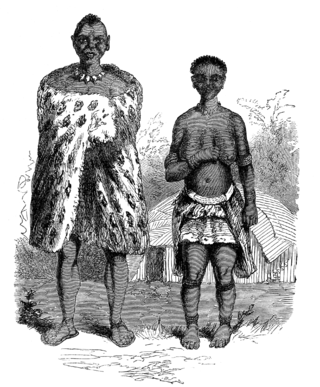
The MaYeyi are Bantu-speaking people of north-western Botswana and north-eastern Namibia. The Yeyi immigrated to the area in the 18th century from the north, and lived in close cooperation with the San people, or Basarwa,in particular,the Xanikhwe

Luengue-Luiana National Park is a national park in Angola.

Mavinga is a National Park in Kuando Kubango Province in south-eastern Angola. It covers an area of 46,076 square kilometres (17,790 sq mi). The Park was proclaimed in 2011 along with the neighbouring Luengue-Luiana National Park, which measures 22,610 square kilometres (8,730 sq mi). The two parks are contiguous and managed as a single unit. The parks were created to conserve the areas’ high ecological and biological value. Mavinga forms the western border of Africa's largest conservation area, the Kavango-Zambezi Trans-Frontier Conservation Area.

Kavango–Zambezi Transfrontier Conservation Area is the second-largest nature and landscape conservation area in the world, spanning the international borders of five countries in Southern Africa. It includes a major part of the Upper Zambezi River and Okavango basins and Delta, the Caprivi Strip of Namibia, the southeastern part of Angola, southwestern Zambia, the northern wildlands of Botswana and western Zimbabwe. The centre of this area is at the confluence of the Zambezi and Chobe Rivers where the borders of Botswana, Namibia, Zambia and Zimbabwe meet. It incorporates a number of notable national parks and nature sites, including Chobe National Park, Hwange National Park, and the Victoria Falls. The region is home to a population of approximately 250,000 animals, including the largest population of African Elephants in the world.

<span class="mw-page-title-main">Bwabwata National Park</span> Namibian national park

Bwabwata National Park is a protected area in northeastern Namibia that was established in 2007 and covers 6,274 km2 (2,422 sq mi). It was created by merging Namibia's Caprivi Game Park and Mahango Game Park. It is situated in the Zambezi and Kavango East regions, extending along the Caprivi Strip. It is bounded by the Okavango River to the west and the Kwando River to the east. Angola lies to the north and Botswana to the south.

<span class="mw-page-title-main">Chinchimane</span> Settlement in Zambezi Region, Namibia

Chinchimane is a settlement in Namibia's Caprivi Strip. It is situated approximately 70 kilometres (43 mi) southwest of the regional capital Katima Mulilo. Chinchimane belongs to the Sibbinda Constituency in Namibia's Zambezi Region.

The Mayuni Conservancy is a conservation area in Linyanti Constituency, in Namibia's northeastern Caprivi Region, along the eastern bank of the Cuando River.

<span class="mw-page-title-main">Mudumu National Park</span> National park in Namibia

Mudumu is a National Park in Caprivi Region of north-eastern Namibia. Established in 1990, the park covers an area of 737 square kilometres (285 sq mi). The Kwando River forms the western border with Botswana. Various communal area conservancies and community forests surround Mudumu National Park.

<span class="mw-page-title-main">NamParks Project</span> Nam parks programme

NamParks or the Namibian National Parks Programme is a programme of the Namibian Ministry of Environment and Tourism (MET). It was established in 2006 and is supported by the Federal Republic of Germany through KfW. It works in Bwabwata, Khaudum, Mudumu and Nkasa Rupara national parks in north eastern Namibia. The parks are part of a larger conservation area, the Kavango–Zambezi Transfrontier Conservation Area. They contain biodiversity and habitat that are not found elsewhere in Namibia. They are also important for tourism. Partners believe that investment in the north eastern parks contributes to the ecological and economic development of the KAZA TFCA.

<span class="mw-page-title-main">Protected areas of Namibia</span>

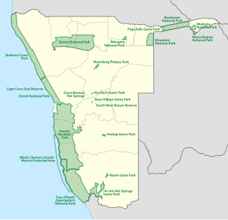
The protected areas of Namibia include its national parks and reserves. With the 2010 declaration of Dorob National Park, Namibia became the first and only country to have its entire coastline protected through a national parks network. Protected areas are subdivided into game reserves and/or nature reserves, such as special protected area, wilderness areas, natural areas, and development areas. There are also recreation reserves. Facilities in the national parks are operated by Namibia Wildlife Resorts. Over 19% of Namibia is protected, an area of some 130,000 square kilometres. However, the Ministry of Environment & Tourism auctions limited hunting rights within its protected areas. The Namibia Nature Foundation, an NGO, was established in 1987 to raise and administer funds for the conservation of wildlife and protected area management. Communal Wildlife Conservancies in Namibia help promote sustainable natural resource management by giving local communities rights to wildlife management and tourism.

The Peace Park Foundation, founded in 1997 by Dr Anton Rupert, President Nelson Mandela and Prince Bernhard of the Netherlands, is an organization that aims to re-establish, renew and conserve large ecosystems in Africa, transcending man-made boundaries by creating regionally integrated and sustainably managed networks of Transfrontier Conservation Areas (TFCAs). Peace Parks Foundation has been involved in the establishment and development of ten of the 18 TFCAs found throughout southern Africa, all of which are in various stages of development. The establishment of each TFCA, or peace park, is complex and far-reaching, and involves several phases of activity, which can take many years to achieve.

References

  1. 1 2 3 4 5 6 7 8 9 10 11 12 13 14 15 16 . Windhoek, Namibia: Ministry of Environment and Tourism Namibia. 2012. p. 55.{{cite book}}: Missing or empty |title= (help)
  2. 1 2 3 4 5 6 7 8 . Windhoek, Namibia: Ministry of Environment and Tourism Namibia. 2010. p. 272.{{cite book}}: Missing or empty |title= (help)
  3. Digby-Clarke, Neil (30 April 2008). "Mamili National Park, surely the jewel in the Caprivi region's crown". Allgemeine Zeitung .
  4. 1 2 3 4 5 6 . Windhoek, Namibia: Ministry of Environment and Tourism Namibia. 2009.{{cite book}}: Missing or empty |title= (help)
  5. . Windhoek, Namibia: Ministry of Environment and Tourism. 2009.{{cite book}}: Missing or empty |title= (help)
  6. Nandi-Ndaitwah, Netumbo (2011). Hon Minister. Mahango Station Kavango Region, Namibia: Republic of Namibia. p. 11.