In 1807 the Ings, then measuring 4 acres, 1 rod, 6 poles and described as meadow, was put up for auction by the landowner William Wells. The nearby Broad Close, measuring 1 acre, 2 rods and 17 poles and also described as meadow, may have been another part of the present SSSI site. At this time the adjacent common land was undergoing enclosure, and also for sale.[5]
Part of this site was sold in 1862 while tenanted by farmer George Heath (born ca. 1832), who was farming 132 acres with his brothers Edward and Robert.[6][7] It was described as "a close of grass land called Ings Close, with a small willow garth therein,[nb 1] situated in the ings of Bishop Monkton, and containing 3 acres and 1 rood or thereabouts."[8]
In 1883 the Ings was sold again, while in the tenancy of Mary Heath (born ca.1821), likely a relative of George Heath who was now farming in Hunslet, Leeds.[9][10] This part of the site was at that time called the Ings Field, comprising two enclosures of "rich feeding grassland" with the Ings Drain running through it. It was measured as four acres, one rod and five poles.[11]
Site location and designation
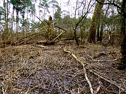
Part of the marsh area
Bishop Monkton Ings is a 37.788 hectares (0.378km2; 0.146sqmi) biological Site of Special Scientific Interest (SSSI).[12] It lies to the south of Ripon, North Yorkshire. Access is via the muddy Ings Lane public footpath running east from Bishop Monkton village to the north-west corner of the site. The track is part of Ripon Rowel Walk.[13] There is no vehicular access, and no facilities. The watercourses Holbeck and Ings Drain run through the site, which contains deciduous woodland, "species-rich marshy grassland subject to winter flooding" and some fen alongside the two streams.[2]
The site was notified as an SSSI on 1 October 1986 for its "diverse range of wetland habitats" including woodland, and also because wetland such as this was once widespread, but is now under threat from land improvement and the drainage requirements of adjacent agricultural land and settlements.[2]
Significant site content
Note: Unless otherwise stated, images of flora and fauna in this article are for illustrative purposes only, and were not taken at this site.
Annual light grazing is required, by cattle, ponies or hill sheep, to maintain a rich and varied diversity of herbs and other biota on the grassland. The purpose of this is to prevent a build-up of tall grasses and dead vegetation, which in turn would inhibit diverse plant growth, and overshadow weaker plants. Grazing should occur between late spring and early autumn if there are no ground-nesting birds there. The size and function of existing drains should be maintained, and some scrub and hedge should be retained. Changes to drainage, and the use of fertiliser, herbicides and pesticides, are strongly discouraged because they would change the quality and diversity of the present plant and animal life.[14]
Development and risk assessment
The bog water here has a natural oily sheen
Both units of fen, marsh and swamp were assessed by Natural England in 2011. The first unit was judged to be in favourable condition, with some hawthornscrub clearance required, although this section passed the assessment due to a good diversity of species, and the grassland was in good condition. The second unit was judged "unfavourable but recovering", because hawthorn scrub was encroaching onto grassland and fen. The assessor found ragwort scattered across the site.[15] No explanation is given for the mention in the assessment of ragwort, but it is possible that a balance had to be made between its situation as a controlled plant,[16] with toxicity to cattle and ponies,[17] and its advantages as a pollinator and ability to host certain insect larvae, such as that of the cinnabar moth.[18][19] In the UK, the cinnabar moth is a priority species.[20]
In October 2016, this site was assessed for any potential damaging effect of mining for minerals, for a period up to 2030. In 2016 the authorities were seeking more sites for sand and gravel quarries, besides the sites that were already being worked.[21][22] In 2018 a permit was granted for a poultry farm next to Bishop Monkton Ings, with the requirement that the poultry and the Ings be separated from one another by trees and a fence.[23]
↑ "Insect fauna in detail"(PDF). static1.squarespace.com. Buglife (Invertebrate Conservation Trust). Archived from the original(PDF) on 13 January 2020. Retrieved 13 January 2020.
↑ Dickinson, Michelle (16 August 2000). "Kirk Deighton SSSI, details". designatedsites.naturalengland.org.uk. Natural England. Retrieved 16 February 2020.
↑ Newton, Joanne (2 October 1988). "Designated sites view: Mar Field Fen SSSI". designatedsites.naturalengland.org.uk. Natural England. Retrieved 20 December 2019. Location is at Harrogate SE 222 819
↑ Newton, Joanee (1 May 1986). "Designated sites view: Quarry Moor SSSI". designatedsites.naturalengland.org.uk. Natural England. Retrieved 20 December 2019. Location is at Harrogate SE 309 693
Eades, P.; Tratt, R.; Shaw, S. (2012). Alkaline Fen and Transition Mire Survey of the North York Moors National Park and Bishop Monkton Ings (report). Telford: Natural England.
This page is based on this Wikipedia article Text is available under the CC BY-SA 4.0 license; additional terms may apply. Images, videos and audio are available under their respective licenses.