Mar Field Fen

Last updated

Mar Field Fen
Site of Special Scientific Interest
Pinguicula vulgaris var. macroceras (flower).JPG
Common butterwort grows at Mar Field Fen [nb 1]
North Yorkshire UK location map (2023).svg
Red pog.svg
Location within North Yorkshire
Location North Yorkshire
Grid reference SE222819
Coordinates 54°13′56″N1°39′39″W / 54.2323°N 1.6609°W / 54.2323; -1.6609
InterestBiological
Area8.8809 hectares (0.08881 km2; 0.03429 sq mi)
Notification 2 October 1988
Location map Magic Map (Defra)

Mar Field Fen is a Site of Special Scientific Interest, or SSSI, north of Masham, North Yorkshire, England, in a rural area known as Marfield. It is situated on land containing woodland carr, fen, spring-fed marshy grassland and drier calcareous grassland, between the River Ure to the east and Marfield Wetland nature reserve to the west. As "one of the best examples of fen habitat in the Vale of York," it is a protected habitat for a variety of plants, including the common butterwort, a carnivorous plant. [1] There is no public access to this site.

Contents

Site history

In the 19th century, the site was in hunting country, where the Bedale Hunt would run. The entrants for the annual Bedale Hunt steeplechase would gather in a field called Marfield, a drier place adjacent to the present SSSI site, before moving on to a field called Whitefield for the start of the race. [2]

Site location and designation

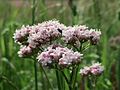
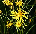
Mar Field Fen is a 8.8809 hectares (0.08881 km2; 0.03429 sq mi) biological Site of Special Scientific Interest (SSSI), [3] consisting of woodland carr, fen and calcareous meadow whose flush and spring fed soils support certain specialised vegetation. [1] The site lies north of Masham, North Yorkshire, on the west bank of the River Ure. There are public footpaths to the east and west of the site, but no public access, vehicle access or facilities. [4] The site was notified on 2 October 1988, being of interest for being "one of the best examples of fen habitat in the Vale of York." [1]

Mar Field Fen SSSI is not to be confused with Marfield Wetlands nature reserve which contains lakes, and lies to the west of the SSSI. Unlike the SSSI, Marfield Wetlands has a car park, bird hides and public facilities. [5]

Significant site content

Flora

On the fen meadow are many species of herbaceous plants, including spotted orchid, common bistort, greater bird's foot trefoil, common valerian, marsh hawksbeard, wild angelica, ragged robin and meadowsweet. These grow beside or among the "locally uncommon" blunt-flowered rush and greater tussock-sedge. Other fen plants here include common reed (Phragmites australis), jointed rush, hairy sedge and lesser pond sedge. Within the site there is also a drier calcareous grassland with its own flora. [1]

At the north end of the site there is "flushed ground," or land with much seepage from the aquifer; some of its plants are "particularly scarce and localised." For example, there is the brown moss Drepanocladus revolvens and tussocks of purple moor-grass. There are also tussocks of bog rush, and on these tussocks are common butterwort and flea sedge. The fen spring-lines have their own special plants: broad-leaved cottongrass (Eriophorum latifolium) which is classed as "uncommon", bogbean, early marsh orchid, marsh valerian (Valeriana dioica), glaucous sedge, carnation sedge and long-stalked yellow sedge (Carex lepidocarpa). [1]

Where the fen meadow and woodland carr meet, there is giant bellflower, marsh horsetail, hemp agrimony, yellow iris or flag, marsh marigold and meadowsweet. In drier places under the trees are: wood anemone, enchanter's nightshade and dog's mercury. Above them in the woodland understorey are guelder rose and grey willow or common sallow. The woodland carr itself has been partially planted with pine and poplar, but the remaining natural or original canopy is ash and alder. [1]

Maintenance

In the woodland carr, minimum interference with natural growth and die-back is recommended, because fallen trees and regrowth will encourage the natural development of diverse habitats, such as glades, areas of young trees, and a mixture of light and shade, and shelter or exposure to wind. It may sometimes be necessary to cut back scrub if the woodland encroaches onto meadow, or to coppice trees to open up the area to light or to prevent trees from falling. Public access should be restricted to protect breeding wildlife or for the sake of public safety. [6]

The flush and spring fen area should be protected from potential risk of commercial water abstraction which would deplete the aquifer, and from agricultural fertiliser or landfill pollution. All of these would disrupt the chemical balance in the aquifer and consequently in the soil, and that in turn would encourage rank grasses, and cause depletion of specialised fen plants. The quality of fen biodiversity should be monitored for signs of change. Light autumn grazing and trampling by cattle is beneficial, so long as the land is not enriched by cattle dung or feed. Moderate trampling may break down leaf litter and create scattered areas of bare soil which would encourage bryophytes and some invertebrates. Drains should not interfere with flushes and springs, nor should they cause any drying-out of land. At this particular site there is necessary incoming water from an adjacent quarry, and that should not be withheld, diverted or obstructed. [6]

The calcareous meadow area requires more maintenance than the wood and fen. To prevent build-up of rank grasses, dead vegetation and scrub, light annual grazing and trampling by cattle is recommended. The aim is to "keep a relatively open sward without causing excessive poaching" and a varied habitat, including perhaps a controlled amount of scrub. Pesticides, herbicides and fertiliser are strongly discouraged. Rabbit damage is a problem on this site, and should be controlled where possible. [6]

Development and risk assessment

The site was assessed by Natural England in May and August 2012. The 3.1179 hectares (0.03118 km2; 0.01204 sq mi) "broadleaved, mixed and yew woodland (lowland)" area was judged to be in favourable condition, having "good ground flora and regeneration." The 5.763 hectares (0.0576 km2; 0.0223 sq mi) lowland fen, marsh and swamp area was judged "unfavourable and recovering," although no details were given. [7]

Regarding future mining of limestone between 2025 and 2030, Gebdykes Quarry applied for a 25.8-hectare (64-acre) extension of the quarry across agricultural land. The potential effect on Mar Field Fen SSSI was considered in relation to that. [8] [9] North Yorkshire County Council confirmed that Mar Field Fen SSSI would be considered in any future local request for planning permission that might affect the site. [10] North Yorkshire County Council's Minerals and Waste Joint Plan 2016–2030 took Mar Field Fen SSSI into consideration regarding possible effects of all potential local requirements for agricultural and commercial exploitation of land in the area. [11] Yorkshire Water's drought plan for 2019 considered the potential permanent effect of water extraction on Mar Field Fen SSSI in the case of future drought and found it to be moderate and adverse. [12]

See also

Other SSSIs in the Ripon and Harrogate region are: [13] Bishop Monkton Ings, [14] Brimham Rocks, [15] Cow Myers, [16] Farnham Mires, [17] Hack Fall Wood, [18] Hay-a-Park, [19] Quarry Moor, [20] and Ripon Parks. [21]

Notes

  1. Unless otherwise stated, the photographs of flora in this article are for plant identification purposes only, and were not taken at this site

Related Research Articles

<span class="mw-page-title-main">Brimham Rocks</span> Site of Special Scientific Interest in North Yorkshire, England

Brimham Rocks, once known as Brimham Crags, is a 183.9-hectare (454-acre) biological Site of Special Scientific Interest (SSSI) and Geological Conservation Review (GCR) site, 8 miles (13 km) north-west of Harrogate, North Yorkshire, England, on Brimham Moor in the Nidderdale Area of Outstanding Natural Beauty. The site, notified as SSSI in 1958, is an outcrop of Millstone Grit, with small areas of birch woodland and a large area of wet and dry heath.

<span class="mw-page-title-main">Bishop Monkton</span> Village and civil parish in North Yorkshire, England

Bishop Monkton is a village and civil parish in the Harrogate district of North Yorkshire, England, about five miles south of Ripon. According to the 2001 census it had a population of 775, increasing slightly to 778 at the 2011 Census. In 2015, North Yorkshire County Council estimated the population to be 760.

<span class="mw-page-title-main">Lambert's Castle</span> Historic hill fort in Dorset, England

Lambert's Castle is an Iron Age hillfort in the county of Dorset in southwest England. Since 1981 it has been designated as a Site of Special Scientific Interest (SSSI) on account of its geology, archaeology and ecology. The hillfort is designated a scheduled monument together with a bowl barrow, the sites of a post-medieval fair and a telegraph station. The site was on the Heritage at Risk Register but was removed in 2022 as a result of the Hillforts and Habitats Project.

<span class="mw-page-title-main">River Thet</span> River in Norfolk, England

The River Thet is a river in Norfolk, England and is a tributary of the River Little Ouse.It rises in Breckland with sources in Deopham Green and Rockland All Saints and joins the Little Ouse in Thetford after flowing approximately southwest.

<span class="mw-page-title-main">Acaster South Ings</span> Site of Special Scientific Interest in North Yorkshire, England

Acaster South Ings is a Site of Special Scientific Interest, or SSSI, near York, England. It consists of two alluvial flood-meadows, and was designated in 1988 because it supports diverse fauna and flora, some of which is rare in the Vale of York area. One of the rarities is the tansy beetle, which feeds on the leaves of the tansy plant.

Trodds Copse is a 25.23 hectare biological Site of Special Scientific Interest (SSSI), in central Hampshire, notified in 1989. It comprises ancient semi-natural woodland, unimproved meadows and flushes.

The Bottoms is a Site of Special Scientific Interest in County Durham, England. It lies just south of the A181 road, roughly midway between the villages of Cassop and Wheatley Hill, some 10 km south-east of Durham city.

<span class="mw-page-title-main">Barnby Broad and Marshes</span>

Barnby Broad and Marshes is a Site of Special Scientific Interest (SSSI) in the Waveney district of the English county of Suffolk. The site is 189.6 hectares in size. It is in the parishes of North Cove and Barnby, located between Beccles and Lowestoft in the north of the county. The site is bordered on its southern edge by the East Suffolk railway line and to the north by the River Waveney. It is a Special Area of Conservation, a Special Protection Area under the EC Birds Directive, and a Ramsar internationally important wetland site. There are two Suffolk Wildlife Trust nature reserves in the site, Castle Marshes and North Cove.

<span class="mw-page-title-main">Blo' Norton and Thelnetham Fens</span>

Blo' Norton and Thelnetham Fens are a 21.3-hectare (53-acre) biological Site of Special Scientific Interest (SSSI) on the Norfolk/Suffolk border. Blo' Norton Fen is in the parish of Blo' Norton in Norfolk and Thelnetham Fen is in Thelnetham parish in Suffolk. It is a Nature Conservation Review site, Grade 2, and part of the Waveney and Little Ouse Valley Fens Special Area of Conservation, Thelnetham Fen is managed by the Suffolk Wildlife Trust and Blo' Norton Fen by the Little Ouse Headwaters Project (LOHP).

<span class="mw-page-title-main">Hay-a-Park Gravel Pit</span> Site of Special Scientific Interest in North Yorkshire, England

Hay-a-Park Gravel Pit is a Site of Special Scientific Interest, or SSSI, adjacent to the east side of the town of Knaresborough, North Yorkshire, England. Having been a disused and flooded quarry since the 1970s, it now consists of the large Hay-a-Park Lake and three smaller ponds, besides associated reedbeds, scrub, woodland and grassland. It was designated as a SSSI in 1995 because it supports a number of wintering birds, including a large flock of goosander. This site is "one of the most northerly inland breeding populations of reed warbler in Britain." Hay-a-Park was once part of a royal park, an early landowner being Edward II.

<span class="mw-page-title-main">Quarry Moor</span> Site of Special Scientific Interest in North Yorkshire, England

Quarry Moor is a Site of Special Scientific Interest, or SSSI, at the south edge of Ripon, North Yorkshire, England, and adjacent to the A61 road. It contains an outcrop of Magnesian Limestone, exposed by former quarrying. 255 million years ago this limestone was the peripheral sediment of a tropical sea. The land was donated in 1945 to the people of Ripon by the town's mayor, Alderman Thomas Fowler Spence, a varnish manufacturer. The land was notified as an SSSI in 1986 because its calcareous grassland supported a large diversity of plant species. The site features a Schedule 8 protected plant, thistle broomrape. The land is protected as a nature reserve, and it is also managed as a recreational area. Therefore, its calcareous grass area is fenced off for protection and study, but it also contains a car park, information signs, a children's play area, accessible paths, benches, and dog waste bins.

<i>Orobanche reticulata</i> Species of flowering plant

Orobanche reticulata is a species of broomrape known by the common name thistle broomrape. It is a parasitic plant whose host is normally the creeping thistle. It is native to the lowlands of Western Europe and Central Asia, but in the United Kingdom it is a rare and protected plant, growing only in Yorkshire, on grassland sites such as Quarry Moor.

<span class="mw-page-title-main">Farnham Mires</span> Site of Special Scientific Interest in North Yorkshire, England

Farnham Mires is a Site of Special Scientific Interest, or SSSI, to the east of the village of Farnham, North Yorkshire, England. It consists of a spring-fed marshy fen or mire with reeds and sedge, and drier calcareous grassland containing a diverse range of flora. It has a history of poaching and fox hunting, but since the late 19th century, the attention of botanists has been drawn to its large variety of flowering plants. It has received some consideration on this account since 1944, and from 1954 it was designated SSSI status. This site has no facilities, and is not open to the public.

<span class="mw-page-title-main">Cow Myers (wetland)</span> Site of Special Scientific Interest in North Yorkshire, England

Cow Myers is a Site of Special Scientific Interest (SSSI) located in the Nidderdale Area of Outstanding Natural Beauty (AONB), near Ripon, North Yorkshire, England. The site was designated in 1984 for its fen and alder carr habitat, which supports a diversity of wetland plant life. Of particular interest are the bird's eye primrose which is scarce in Yorkshire, and early marsh orchid. There is no public access to this site, no vehicular access, and no public facilities.

<span class="mw-page-title-main">Bishop Monkton Ings</span> Site of Special Scientific Interest in North Yorkshire, England

Bishop Monkton Ings is a Site of Special Scientific Interest, or SSSI, situated east of Bishop Monkton village in North Yorkshire, England. It consists mostly of marshy, calcareous grassland, with some broadleaved woodland, and some fen alongside the two watercourses which run through the site. This varied wetland forms a habitat for a variety of plants, including the semi-parasitic marsh lousewort (Pedicularis palustris).

<span class="mw-page-title-main">Hack Fall Wood</span> Site of Special Scientific Interest in North Yorkshire, England

Hack Fall Wood, otherwise known as Hackfall, is a Site of Special Scientific Interest, or SSSI, of 44.8687 hectares, lying north-east of the village of Grewelthorpe, North Yorkshire, England. During the 18th century it was landscaped in the picturesque style by landowner William Aislabie, who created views by engineering streams and pools, planting trees and building follies. J. M. W. Turner and William Sawrey Gilpin painted it, and pictures of it featured on Catherine the Great's 1773 Wedgwood dinner service. Some 19th century writers called it "one of the most beautiful woods in the country."

<span class="mw-page-title-main">Ripon Parks</span> Site of Special Scientific Interest in North Yorkshire, England

Ripon Parks is a Site of Special Scientific Interest, or SSSI, situated north of Ripon, to the west of the River Ure and to the east of the village of North Stainley, in North Yorkshire, England. It was once part of the land held since the Middle Ages as a deer park by the archbishops of York and the canons of Ripon. The site was designated as an SSSI in 1983, because its varied habitats are valued for their breeding birds, amphibians and varied flora. The woods here are "of note" for the parasitic flowers of common toothwort and yellow star-of-Bethlehem. A small part of the site is accessible via public footpaths; there are no public facilities or dedicated car parks. The site incorporates the High Batts Nature Reserve, which is privately run for training, recording and educational purposes, and accessible to members only, except for its annual open day. Ripon Parks is now owned by the Ministry of Defence, and parts of the site are used as military training areas.

<span class="mw-page-title-main">Kirk Deighton SSSI</span> Site of Special Scientific Interest in North Yorkshire, England

Kirk Deighton SSSI is a Site of Special Scientific Interest (SSSI) in Alton's Field, Kirk Deighton, North Yorkshire, England. This site has been recognised as having one of the largest known breeding populations of great crested newts in the United Kingdom. It is a Special Area of Conservation, and is listed for protection under a number of directives. This ordinary-looking grassland field, with a couple of ponds in it, is ideal habitat for the newts, which use the grassland for foraging, the ponds for breeding, and surrounding walls, hedges and woodpiles for hibernation. The site is not accessible to the public, and it is not permissible to survey the ponds without a licence.

<span class="mw-page-title-main">Stonesfield Common, Bottoms and Banks</span>

Stonesfield Common, Bottoms and Banks is a 27.45-hectare (67.8-acre) biological Site of Special Scientific Interest (SSSI) south of Stonesfield in Oxfordshire.

References

  1. 1 2 3 4 5 6 "Citation, Mar Field Fen SSSI" (PDF). designatedsites.naturalengland.org.uk. Natural England. 28 October 1988. Retrieved 8 January 2020.
  2. "Bedale Hunt point-to-point steeplechase". Yorkshire Post and Leeds Intelligencer. British Newspaper Archive. 7 April 1892. p. 8 col 6. Retrieved 15 January 2020.
  3. Newton, Joanne (2 October 1988). "Designated sites view, details: Mar Field Fen SSSI". designatedsites.naturalengland.org.uk. Harrogate SE 222 819: Natural England. Retrieved 20 December 2019.{{cite web}}: CS1 maint: location (link)
  4. "Magic Map, Mar Field Fen SSSI". magic.defra.gov.uk. Defra. Retrieved 8 January 2020.
  5. "How to get to Marfield Wetlands Nature Reserve in Yorkshire by Bus or Train?". moovitapp.com. Moovit. 2020. Retrieved 14 January 2020.
  6. 1 2 3 "Management, Mar Field Fen SSSI" (PDF). designatedsites.naturalengland.org.uk. Natural England. 22 December 2004. Retrieved 8 January 2020.
  7. Newton, Joanne (8 May 2012). "Condition, Mar Field Fen SSSI". designatedsites.naturalengland.org.uk. Natural England. Retrieved 8 January 2020.
  8. "SA report appendix 3c Harrogate and Hambleton districts (split) Joint minerals and waste plan. Sustainability Appraisal Report Appendix 3: Assessment of Sites" (PDF). democracy.york.gov.uk. York City Council. Retrieved 16 January 2020.
  9. "Public access, property history". planning.hambleton.gov.uk. Hambleton District Council. 2020. Retrieved 16 January 2020.
  10. "Minerals and Waste Joint Plan.Minerals and Waste Joint Plan. Preferred Options Consultation Authorities Response to Responses" (PDF). northyorkmoors.org.uk. City of York Council, North York Moors National Park Authority, North Yorkshire County Council. August 2015. Retrieved 16 January 2020.
  11. "Minerals and Waste Joint Plan Appendix 1 Allocated Sites Areas of Search" (PDF). northyorks.gov.uk. North Yorkshire County Council. 2016. Retrieved 16 January 2020.
  12. "Drought plan option" (PDF). yorkshirewater.com. Yorkshire Water. 2019. Retrieved 16 January 2020.
  13. "Appendix III: wildlife sites in Harrogate district" (PDF). Harrogate.gov.uk (cached). Harrogate: Harrogate Council. July 2009. Retrieved 24 December 2019.
  14. Newton, Joanne (1 October 1986). "Designated sites view: Bishop Monkton Ings SSSI". designatedsites.naturalengland.org.uk. Natural England. Retrieved 20 December 2019.
  15. "Designated sites view, Brimham Rocks SSSI, details". designatedsites.naturalengland.org.uk. Natural England. 19 February 1988. Retrieved 27 January 2020.
  16. Newton, Joanne (26 January 1984). "Designated sites view: Cow Myers SSSI". designatedsites.naturalengland.org.uk. Harrogate: Natural England. Retrieved 20 December 2019.
  17. Newton, Joanne (13 January 1984). "Designated sites view: Farnham Mires SSSI". designatedsites.naturalengland.org.uk. Natural England. Retrieved 20 December 2019.
  18. "Designated sites view: Hack Fall Wood SSSI". designatedsites.naturalengland.org.uk. Natural England. 16 October 1989. Retrieved 20 December 2019.
  19. "Designated sites view: Hay-a-Park site detail". designatedsites.naturalengland.org.uk. Harrogate: Natural England. 15 June 1995. Retrieved 20 December 2019.
  20. Newton, Joanee (1 May 1986). "Designated sites view: Quarry Moor SSSI". designatedsites.naturalengland.org.uk. Harrogate SE 309 693: Natural England. Retrieved 20 December 2019.{{cite web}}: CS1 maint: location (link)
  21. Newton, Joanne (1983). "Natural England designated sites view: Ripon Parks SSSI". Designatedsites.naturalengland.co.uk. Natural England. Retrieved 20 December 2019.