A cist is a small stone-built coffin-like box or ossuary used to hold the bodies of the dead. Examples can be found across Europe and in the Middle East. A cist may have been associated with other monuments, perhaps under a cairn or long barrow. Several cists are sometimes found close together within the same cairn or barrow. Often ornaments have been found within an excavated cist, indicating the wealth or prominence of the interred individual.

A chambered cairn is a burial monument, usually constructed during the Neolithic, consisting of a sizeable chamber around and over which a cairn of stones was constructed. Some chambered cairns are also passage-graves. They are found throughout Britain and Ireland, with the largest number in Scotland.

A cairn is a man-made pile of stones. The word cairn comes from the Scottish Gaelic: càrn[ˈkʰaːrˠn̪ˠ].

Gower or the Gower Peninsula in southwest Wales, projects towards the Bristol Channel. It is the most westerly part of the historic county of Glamorgan. In 1956, the majority of Gower became the first area in the United Kingdom to be designated an Area of Outstanding Natural Beauty.

A tumulus is a mound of earth and stones raised over a grave or graves. Tumuli are also known as barrows, burial mounds or kurgans, and may be found throughout much of the world. A cairn, which is a mound of stones built for various purposes, may also originally have been a tumulus.

The court cairn or tomb is a megalithic type of chamber tomb and gallery grave, specifically a variant of the chambered cairn, found in western and northern Ireland, and in mostly southwest Scotland, around 4000–3500 BCE, but many remained in use until as late as the Bronze Age transition, c. 2200 BCE. They are generally considered to be the earliest chambered cairn tombs in Scotland, and their construction technique was probably brought from Scotland to Ireland. In Scotland, they are most common in what today are Argyll and Dumfries and Galloway, though a small outlying group have been found near Perth.

Cairnpapple Hill is a hill with a dominating position in central lowland Scotland with views from coast to coast. It was used and re-used as a major ritual site over about 4000 years, and in its day would have been comparable to better known sites like the Standing Stones of Stenness. The summit lies 312 m above sea level, and is about 2 miles (3 km) north of Bathgate. In the 19th century the site was completely concealed by trees, then in 1947–1948 excavations by Stuart Piggott found a series of ritual monuments from successive prehistoric periods. In 1998, Gordon Barclay re-interpreted the site for Historic Scotland. It is designated a scheduled ancient monument.

Dunkery Beacon at the summit of Dunkery Hill is the highest point on Exmoor and in Somerset, England. It is also the highest point in southern England outside of Dartmoor.

Kilmartin Glen is an area in Argyll not far from Kintyre. It has the most important concentration of Neolithic and Bronze Age remains in mainland Scotland.

Loudoun Hill, also commonly Loudounhill, is a volcanic plug in East Ayrshire, Scotland. It is located near the head of the River Irvine, east of Darvel. One real and one fictional battle have been fought around Loudoun Hill.
Fortingall is a small village in highland Perthshire, Scotland, in Glen Lyon. Its nearest sizable neighbours are Aberfeldy and Kenmore. Its Gaelic name is Fartairchill, which may be translated as something like: "Escarpment Church", i.e. "church at the foot of an escarpment or steep slope".

Càrn Liath is an Iron Age broch on the eastern shore of the Scottish Highlands, near Golspie, Sutherland.

Prehistoric Orkney refers only to the prehistory of the Orkney archipelago of Scotland that begins with human occupation. Although some records referring to Orkney survive that were written during the Roman invasions of Scotland, “prehistory” in northern Scotland is defined as lasting until the start of Scotland’s Early Historic Period (around AD 600.

Mellor hill fort is a prehistoric site in North West England, that dates from the British Iron Age—about 800 BC to 100 AD. Situated on a hill in Mellor, Greater Manchester, on the western edge of the Peak District, the hill fort overlooks the Cheshire Plain. Although the settlement was founded during the Iron Age, evidence exists of activity on the site as far back as 8,000 BC; during the Bronze Age the hill may have been an area where funerary practices were performed. Artefacts such as a Bronze Age amber necklace indicate the site was high status and that its residents took part in long-distance trade. The settlement was occupied into the Roman period. After the site was abandoned, probably in the 4th century, it was forgotten until its rediscovery in the 1990s.

Brown Willy is a hill in Cornwall, England, United Kingdom. The summit, at 1,378 feet above sea level, is the highest point of Bodmin Moor and of Cornwall as a whole. It is about 2+1⁄2 miles northwest of Bolventor and 4 miles southeast of Camelford. The hill has a variable appearance that depends on the vantage point from which it is seen. It bears the conical appearance of a sugarloaf from the north but widens into a long multi-peaked crest from closer range.

Prehistoric art in Scotland is visual art created or found within the modern borders of Scotland, before the departure of the Romans from southern and central Britain in the early fifth century CE, which is usually seen as the beginning of the early historic or Medieval era. There is no clear definition of prehistoric art among scholars and objects that may involve creativity often lack a context that would allow them to be understood.
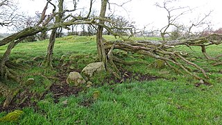
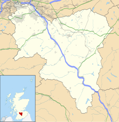
Cairnduff,Cairn Duff or Carn Duff is a roughly circular Bronze Age burial cairn, located on the lands of High Peacockbank Farm near the town of Stewarton in East Ayrshire, Scotland. It was built around 3000 years ago.
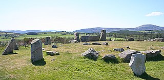
Tomnaverie stone circle is a recumbent stone circle set on the top of a small hill in lowland northeast Scotland. Construction started from about 2500 BC, in the Bronze Age, to produce a monument of thirteen granite stones including a massive 6.5-ton recumbent stone lying on its side along the southwest of the circle's perimeter. Within the 17-metre (56 ft) circle are kerb stones encircling a low 15-metre (49 ft) ring cairn but the cairn itself no longer exists.

Chapel Hill, Balladoole is a significant historical and archaeological site in Arbory on the Isle of Man. The site is a short distance from Castletown in the south of the Island. It is located on a small hilltop overlooking the coast. Balladoole has undergone extensive archaeological excavations in the 20th century, most notably in 1944-1945 by German archaeologist Gerhard Bersu who was interned on the Isle of Man during World War II.