The county was established as a shire (the area controlled by a sheriff) in the twelfth century, covering most of the basin of the River Clyde. The area was sometimes known as Clydesdale. In the early fifteenth century the western part of the shire was removed to become Renfrewshire. The historic county of Lanarkshire includes Glasgow, but the city had a separate lieutenancy from 1893. A Lanarkshire County Council existed from 1890 until 1975, which was based in Glasgow until 1964 when it moved to Hamilton.
Map of Scottish provinces in 1689, with Lanarkshire labelled as "Clydesdale".
It is not known exactly when the shire of Lanark was created; it seems likely that it was created by David I (reigned 1124–1153) who was generally responsible for introducing shires as part of his introduction of Anglo-Norman style administration to Scotland. However, the first documented reference to Lanarkshire dates from the reign of David's successor, Malcolm IV (reigned 1153–1165).[1]
Lanarkshire covered much of the basin of the River Clyde, and took its name from the town of Lanark, which is near the geographic centre of the county and served as the first county town. When first created the shire included on its western side an area south of the Clyde stretching out to the Firth of Clyde. This western area was made the separate county of Renfrewshire in the early fifteenth century. The remainder of Lanarkshire was then divided into two wards, each with their own sheriff-substitute: Over Ward was administered from Lanark, and Nether Ward was administered from Rutherglen and Hamilton at different times.[2] In the mid-eighteenth century the two wards were replaced with three wards: Upper Ward based in Lanark, Middle Ward based in Hamilton, and Lower Ward based in Glasgow.[3][4]
The former headquarters of Lanark County Council at Lanarkshire House in Glasgow
Elected county councils were created in 1890 under the Local Government (Scotland) Act 1889. Lanarkshire County Council covered the combined area of the three wards, but excluding the three burghs of Airdrie, Glasgow and Hamilton, which were deemed capable of running their own affairs. Glasgow was subsequently made a county of itself in 1893, also removing the city from the rest of Lanarkshire for judicial and lieutenancy purposes.[5] Reforms to county council powers in 1930 saw Airdrie and Hamilton brought within the administrative area of the county council.[6]
County Buildings, Hamilton: County Council's headquarters after 1964.
Lanarkshire County Council was initially based at County Buildings in Wilson Street in Glasgow; whilst the city was outside the area controlled by the county council, it was found to be the most accessible meeting place for the councillors. From 1930 the county council was based at Lanarkshire House in Ingram Street in Glasgow.[7][8] Lanark County Council relocated to Lanark County Buildings in Hamilton in 1964.[9][10]
In 1975, the county council was abolished under the Local Government (Scotland) Act 1973, which established a new system of upper-tier regions and lower-tier districts. Lanarkshire was included within the Strathclyderegion, and the county council's former area was divided between seven districts:
Further reforms in 1996 under the Local Government etc. (Scotland) Act 1994 saw the regions and districts abolished and replaced by all-purpose unitary council areas. Since then Lanarkshire has straddled the modern council areas of:
The Lanarkshire lieutenancy area was redefined at the same time to cover all of South Lanarkshire and most of North Lanarkshire, but excluding the area around Cumbernauld and Kilsyth, with the excluded area roughly corresponding to the parts of North Lanarkshire which had been in Dunbartonshire and Stirlingshire prior to 1975.[12][13]
North Lanarkshire and South Lanarkshire have a joint board for valuation and electoral registration. There is also a joint health board, which does not cover Rutherglen and the surrounding area in South Lanarkshire. The boundaries of the historic county of Lanarkshire, excluding the city of Glasgow, are still used for some limited official purposes connected with land registration, being a registration county.[14]
Coat of arms
Lanarkshire's arms, as seen on the Great Western Bridge in Glasgow
Lanarkshire was granted a coat of arms by the Lord Lyon on 24 December 1886. The arms is: Party per chevron gules and argent, two cinquefoils pierced in chief ermine, and in base a man's heart counter-changed. The cinquefoils come from the arms of the Clan Hamilton, and the heart from the arms of the Clan Douglas, the two main local families. The crest is a demi-eagle displayed with two heads, sable beaked gules. The motto is VIGILANTIA.[15]
From the mid-eighteenth century to the early twentieth century Lanarkshire profited from its rich seams of coal in places such as Glenboig.[4] As the coal industry developed around Glasgow in the 1700s the price of coal to the city rose under the control of a cartel of coal owners.[17] The solution was to carve out a canal to take advantage of the good (and uncontrolled) coal deposits of the Monklands area. By 1793, the Monklands canal was completed and the Lanarkshire coal industry thrived.[18] The resulting boom lasted for over 100 years but reached its peak by the second decade of the twentieth century and even two world wars failed to halt the contraction. Output in the county continued to fall and the National Coal Board concentrated investment in Ayrshire, Fife and the Lothians. By 1970 there were only four collieries left in Lanarkshire and the closure of Cardowan in 1983 brought the long decline to an end.[19]
Transport
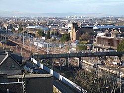
The West Coast Mainline running through Motherwell
Lanarkshire hosted the International Children's Games in August 2011.[20] A total of 1,300 competitors and coaches, along with administrators and delegates, representing 77 cities from 33 countries worldwide attended.
This page is based on this Wikipedia article Text is available under the CC BY-SA 4.0 license; additional terms may apply. Images, videos and audio are available under their respective licenses.