Related Research Articles
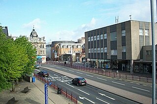
Hamilton is a large town in South Lanarkshire, Scotland. It serves as the main administrative centre of the South Lanarkshire council area. It sits 10 miles (16 km) south-east of Glasgow, 37 miles (60 km) south-west of Edinburgh and 74 miles (120 km) north of Carlisle. It is situated on the south bank of the River Clyde at its confluence with the Avon Water. Hamilton is the county town of the historic county of Lanarkshire and is the location of the headquarters of the modern local authority of South Lanarkshire.

South Lanarkshire is one of 32 unitary authorities of Scotland. It borders the south-east of the City of Glasgow and contains some of Greater Glasgow's suburban towns, also containing many rural towns and villages. It also shares borders with Dumfries and Galloway, East Ayrshire, East Renfrewshire, North Lanarkshire, the Scottish Borders and West Lothian. It includes most of the historic county of Lanarkshire.

Lanarkshire, also called the County of Lanark, is a historic county, lieutenancy area and registration county in the central Lowlands of Scotland.

Dunbartonshire or the County of Dumbarton is a historic county, lieutenancy area and registration county in the west central Lowlands of Scotland lying to the north of the River Clyde. Dunbartonshire borders Perthshire to the north, Stirlingshire to the east, Lanarkshire and Renfrewshire to the south, and Argyllshire to the west. The boundaries with Lanarkshire and Stirlingshire are split in two owing to the existence of an exclave around Cumbernauld.

East Kilbride is the largest town in South Lanarkshire in Scotland and the country's sixth-largest city or town by population. It was also designated Scotland's first new town on 6 May 1947. The area lies on a raised plateau to the south of the Cathkin Braes, about eight miles southeast of Glasgow and close to the boundary with East Renfrewshire. East Kilbride is twinned with the town of Ballerup, in Denmark.

Motherwell is a large town and former burgh in North Lanarkshire, Scotland, United Kingdom, south east of Glasgow. It has a population of around 32,120. Historically in the parish of Dalziel and part of Lanarkshire, Motherwell is the headquarters for North Lanarkshire Council. Geographically the River Clyde separates Motherwell from Hamilton to the west whereas the South Calder Water separates Motherwell from Carfin to the north-east and New Stevenston and Bellshill towards the north.

Blantyre is a town and civil parish in South Lanarkshire, Scotland, with a population of 16,900. It is bounded by the River Clyde to the north, the Rotten Calder to the west, the Park Burn to the east and the Rotten Burn to the south.
Strathkelvin is the strath of the River Kelvin in west central Scotland, close to the city of Glasgow. The name Strathkelvin was formerly (1975–96) used for one of nineteen local government districts in the Strathclyde region of Scotland.

Wishaw is a large town in North Lanarkshire, Scotland, on the edge of the Clyde Valley, 15 miles (24 km) south-east of Glasgow city centre. The Burgh of Wishaw was formed in 1855 within Lanarkshire. it formed a joint large burgh with its neighbour Motherwell from 1920 until its dissolution when Scottish local authorities were restructured in 1975, and was then in Motherwell district within the Strathclyde region until 1996. The town is part of the Motherwell and Wishaw constituency. It has the postal code of ML2 and the dialling code 01698.

Calderbank is a village outside the town of Airdrie, North Lanarkshire, Scotland. It lies west of the M73, on the west bank of the North Calder Water. The village lies 13 miles (21 km) east of Glasgow city centre and around 34 miles (55 km) west of Edinburgh. Other nearby towns include: Airdrie, Coatbridge, Bellshill and Motherwell. It has a population of about 1,560 (mid-2020 est.)

The Central Belt of Scotland is the area of highest population density within Scotland. Depending on the definition used, it has a population of between 2.4 and 4.2 million, including Greater Glasgow, Ayrshire, Falkirk, Edinburgh, Lothian and Fife.
Peel Park is an area of East Kilbride in South Lanarkshire, Scotland. It is a business park, and home to the following companies:
College Milton is an area of the Scottish new town East Kilbride, in South Lanarkshire.

Mossend is a small town in North Lanarkshire, Scotland, located on the A775 road to the immediate east of its 'sister town' Bellshill, west of the villages of Holytown and New Stevenston, north of the larger town of Motherwell and south of the Eurocentral industrial park and the M8 motorway. Along with Holytown, it forms a council ward which had a population of 13,480 in 2019, Mossend's estimated population being around half of that total.

The A725 road in Scotland is a major route which is a trunk road dual carriageway for almost its whole length, connecting several of the large towns of North Lanarkshire and South Lanarkshire, linking the M8 and M74 motorways; it has been upgraded frequently since its construction, with the most recent major work completed in 2017. In combination with the A726 road which meets the M77 motorway, it forms a southern and eastern bypass for the city of Glasgow.

The A726 road in Scotland is a major route with several distinct sections with different characteristics and names; owing to its stages of construction, since 2005 it has two separate parts, the first running between Strathaven in South Lanarkshire and Junction 5 of the M77 motorway south of Newton Mearns in East Renfrewshire via East Kilbride, and the other running between Junction 3 of the M77 and the M898 motorway near the Erskine Bridge, via Paisley and Junction 29 of the M8 motorway near Glasgow International Airport.

The A727 road in Scotland runs from East Kilbride in South Lanarkshire, through East Renfrewshire, to Junction 3 of the M77 motorway in Glasgow.
Westfield is an area of the town of Cumbernauld in Scotland. Westfield is a popular residential area originally built by Cumbernauld Development Corporation in the late 1970s and early 1980s. It comprises a residential area and a large industrial estate. Historically there was a farm at Westfield as shown on Roy's map of the Lowlands and the 1st 25 inch Ordnance Survey Map of Scotland. It is located near Condorrat and Broadwood Stadium, home of Clyde FC. Historically, there were two local primary schools, St Francis of Assisi Primary School and Westfield Primary School. St. Francis of Assisi Primary School closed in 2009. The site has been re-developed by North Lanarkshire Council with new, high quality social housing available to rent. The new street is named Netherinch Way. Westfield also has other modern, private developments for example a new Bellway Housing development sits near Broadwood stadium along with a neighboring housing development. Westfield has a selection of frequent bus services to Airdrie, Cumbernauld Town Centre, Glasgow, Kilsyth and Kirkintilloch with buses operated by David Allan Coaches, First Group & McGills. In 2017 plans for a new retail park near Broadwood Studium were approved.

Blairlinn is the site of one of Cumbernauld's several industrial estates built as satellite developments on the periphery of the Scottish town's residential areas.
References
Coordinates: 55°44′54″N4°10′05″W / 55.74833°N 4.16806°W
| | This South Lanarkshire location article is a stub. You can help Wikipedia by expanding it. |