Hamilton is a large town in South Lanarkshire, Scotland. It serves as the main administrative centre of the South Lanarkshire council area. It sits 10 miles (16 km) south-east of Glasgow, 37 miles (60 km) south-west of Edinburgh and 74 miles (120 km) north of Carlisle. It is situated on the south bank of the River Clyde at its confluence with the Avon Water. Hamilton is the county town of the historic county of Lanarkshire and is the location of the headquarters of the modern local authority of South Lanarkshire.

Lanarkshire, also called the County of Lanark, is a historic county, lieutenancy area and registration county in the central Lowlands of Scotland.

Rutherglen is a town in South Lanarkshire, Scotland, immediately south-east of the city of Glasgow, 3 miles (5 km) from its centre and directly south of the River Clyde. Having existed as a Lanarkshire burgh in its own right for more than 800 years, in 1975 Rutherglen lost its own local council and administratively became a component of the City of Glasgow District within the Strathclyde region. In 1996 the towns were reallocated to the South Lanarkshire council area.

East Kilbride is the largest town in South Lanarkshire in Scotland and the country's sixth-largest locality by population. It was also designated Scotland's first new town on 6 May 1947. The area lies on a raised plateau to the south of the Cathkin Braes, about eight miles southeast of Glasgow and close to the boundary with East Renfrewshire.

Cambuslang is a town on the south-eastern outskirts of Glasgow, Scotland. With approximately 30,000 residents, it is the 27th largest town in Scotland by population, although, never having had a town hall, it may also be considered the largest village in Scotland. It is within the local authority area of South Lanarkshire and directly borders the town of Rutherglen to the west. Historically, it was a large civil parish incorporating the nearby hamlets of Newton, Flemington, Westburn and Halfway.

Blantyre is a town and civil parish in South Lanarkshire, Scotland, with a population of 16,900. It is bounded by the River Clyde to the north, the Rotten Calder to the west, the Park Burn to the east and the Rotten Burn to the south.

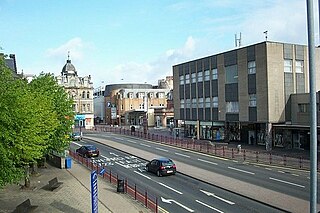
Strathaven is a historic market town in South Lanarkshire, Scotland and is the largest settlement in Avondale. It is 7.5 kilometres (4.7 mi) south of Hamilton. The Powmillon Burn runs through the town centre, which joins the Avon Water to the east of the town.

Wishaw is a large town in North Lanarkshire, Scotland, on the edge of the Clyde Valley, 15 miles (24 km) south-east of Glasgow city centre. The Burgh of Wishaw was formed in 1855 within Lanarkshire. it formed a joint large burgh with its neighbour Motherwell from 1920 until its dissolution when Scottish local authorities were restructured in 1975, and was then in Motherwell district within the Strathclyde region until 1996. The town is part of the Motherwell and Wishaw constituency. It has the postal code of ML2 and the dialling code 01698.

Hairmyres is an area of East Kilbride in South Lanarkshire, Scotland, situated on the west side of the town, close to the main road to Eaglesham and Kilmarnock, and is 2+1⁄4 miles from the Glasgow City Council boundary at the Carmunnock Bypass and nine miles south of the city centre of Glasgow.

East Kilbride railway station serves the town of East Kilbride, South Lanarkshire, Scotland. The station is managed by ScotRail and it is a terminus on the former Busby Railway. The station is 11+1⁄2 miles (18.5 km) southeast of Glasgow Central.

Auchinloch is a village in Scotland, situated within the North Lanarkshire local authority area but very close to the boundary with East Dunbartonshire and sharing the G66 postcode of the town of Kirkintilloch and the adjoining village of Lenzie, located a short distance to the north. Other nearby settlements in North Lanarkshire are Stepps to the south and Chryston to the south-east, each approximately 1.3 miles (2.1 km) away across farmland and on the opposite side of the M80 motorway; the City of Glasgow boundary and the suburb of Robroyston is about the same distance to the west. In previous years Auchinloch was in the Parish of Cadder and, from 1975 until 1996, the district of Strathkelvin within Strathclyde Region.
Stonehouse is a rural village in South Lanarkshire, Scotland. It is on Avon Water in an area of natural beauty and historical interest, near to the Clyde Valley. It is on the A71 trunk road between Edinburgh and Kilmarnock, near the towns of Hamilton, Larkhall and Strathaven. The population of Stonehouse is around 7,500.
East Mains is an area of the Scottish new town East Kilbride, in South Lanarkshire.
Mossneuk is a predominantly residential area in the South-West of the Scottish new town East Kilbride, in South Lanarkshire.
Nerston is a village situated on the northern green-belt boundary of the new town of East Kilbride in South Lanarkshire, Scotland.
West Mains is an area of the Scottish new town East Kilbride, in South Lanarkshire.

Ravenscraig is a village and new town, located in North Lanarkshire, Scotland, around 1½ miles east of Motherwell. Ravenscraig was formerly the site of Ravenscraig steelworks; once the largest hot strip steel mill in western Europe, the steelworks closed in 1992, and is now almost totally demolished.

The A726 road in Scotland is a major route with several distinct sections with different characteristics and names; owing to its stages of construction, since 2005 it has two separate parts, the first running between Strathaven in South Lanarkshire and Junction 5 of the M77 motorway south of Newton Mearns in East Renfrewshire via East Kilbride, and the other running between Junction 3 of the M77 and the M898 motorway near the Erskine Bridge, via Paisley and Junction 29 of the M8 motorway near Glasgow International Airport.

Hamilton West is an area of the town of Hamilton in South Lanarkshire, Scotland.

Calderwood is a neighbourhood of the Scottish new town of East Kilbride, in South Lanarkshire. It lies on its north-east edge and is one of the largest areas of the town.