Broomhill, Glasgow

Last updated

Broomhill
Broomhill Cross - geograph.org.uk - 59303.jpg
Glasgow UK location map.svg
Red pog.svg
Broomhill
Location within Glasgow
OS grid reference NS547672
Council area
Lieutenancy area
  • Glasgow
Country Scotland
Sovereign state United Kingdom
Post town GLASGOW
Postcode district G11
Dialling code 0141
Police Scotland
Fire Scottish
Ambulance Scottish
UK Parliament
Scottish Parliament
List of places
UK
Scotland
Glasgow
55°52′34″N4°19′27″W / 55.875981°N 4.324036°W / 55.875981; -4.324036 Coordinates: 55°52′34″N4°19′27″W / 55.875981°N 4.324036°W / 55.875981; -4.324036

Broomhill is a district in the West End of the city of Glasgow, Scotland. North of the River Clyde, it is bounded by the districts of Thornwood and Partick to the south, Hyndland to the east, and Jordanhill, Scotstoun and Victoria Park to the west.

Contents

The main streets in the district are Crow Road and Broomhill Drive. [1] Crow Road is a main artery in the West End and provides links to Partick at its south end and Anniesland at its north end.

Transport to and from the area is supported by First Glasgow bus services 4 & 16 along Crow Road, and various "dial buses" on Broomhill Drive, and the nearby train stations of Hyndland and Jordanhill.

Schools

Broomhill Primary School's facilities previously consisted of two buildings – the 'annexe' which housed the younger children and the main building with classrooms for the older members of the school. In 2018 a modern building for the entire school was opened, featuring an all-weather sports pitch. The old annex closed, and its demolition began in late 2019.

Three state secondary schools serve the area. The recently refurbished, non-denominational Hyndland Secondary and the recently rebuilt Roman Catholic St Thomas Aquinas are the two main secondary schools.

The area also has a 'college school', Jordanhill School, situated next to the Jordanhill College campus, which is directly funded by the Scottish Government because it was a demonstrator school for the former Jordanhill College of Education, now part of the University of Strathclyde. This school has recently undergone major development work including new science labs in a new building, and sports facilities. Despite the fact that it is within the local authority's education provision, so many local parents wish their children to attend Jordanhill that there is a waiting list, with names being posted from a very early age. Well-performing children may also get referrals from their primary school teachers to help them.

There are also three independent, fee-paying schools nearby: Kelvinside Academy, High School of Glasgow and The Glasgow Academy.

Retail and other local services

Broomhill has its own shopping centre located on Broomhill Drive, with shops including a newsagent, a restaurant, a laundrette, Papa John's, a dentist's surgery and a Co-op convenience store. [2]

There is also a large number of shops on Crow Road, including cafes and restaurants, Café Circa and a café bar and restaurant, The Marlborough. There is a gift and jewellery shop, a florist, a driving school, several hairdressers, a hardware shop with emergency call-out locksmith service, a funeral director, Gray's Kitchen Delicatessen, award-winning butcher "Christies" and various general grocers/newsagents.

Sport

Broomhill Sports Club is a local parent-led, inclusive, multi-sports club. The club is based at several local schools and welcomes children and adults in to participate in several sports. The club was founded by Broomhill Primary Parents in 2004 [3] and now has a membership of more than 700 local children. The club also provided the foundations for the local semi-professional football club, BSC Glasgow F.C. [4]

There are also clubs for boxing/martial arts, [5] lawn bowls [6] and tennis [7] in the area.

Churches

The local Church of Scotland parish church is Broomhill Hyndland Church (a merger with the neighbouring congregation in 2017), [8] founded in 1899 and home to several community organisations including Brownies, Guides and the 130th Glasgow Boys Brigade Company. [9] Another local church, with similar associated clubs, [10] is Balshsgray Victoria Park (BVP); [11] the local Roman Catholic congregation is served by the church of Our Lady of Perpetual Succour. [12]

Army and Territorial Army

There is also the 207 (City of Glasgow) Battery Headquarters and C Troop, 105th Regiment Royal Artillery (Volunteers) – Royal Artillery. This is one of the locations of the 207 Battery, Lanarkshire and Lothian gunners. HQ (Cameronian) and C (Lanark) Troop is based on Crow Road, whilst D (Lothian) is based in Edinburgh. Within the base, there are drill halls, classrooms, stores, armoury, garages, kitchens, and bars.

The Territorial Army shares its base with 'A' Troop Royal Artillery, a detachment of the Glasgow & Lanarkshire Battalion Army Cadet Force. This group is amongst the most popular in Scotland with 12 to 17-year-olds.

The base is also home to 62 (2nd Glasgow) Squadron of the Air Training Corps, one of the largest and most successful squadrons in the Glasgow and West of Scotland Wing.

Housing

Broomhill has a variety of housing throughout the district. Victorian tenements similar to those in neighbouring Hyndland are predominant, but there are areas of terraced and semi-detached housing in the area.

As well as significant renovation to Social Housing in the area, undertaken in 2013, [13] the building of the former Anniesland College at the bottom of Broomhill Drive is to be converted into several luxury apartments, restoring the main Victorian facade.

See also

Related Research Articles

<span class="mw-page-title-main">Glasgow City Council</span> Scottish unitary authority council in Glasgow, Scotland, UK

Glasgow City Council is the local government authority for the city of Glasgow, Scotland. In its modern form it was created in 1996. Glasgow was formerly governed by a corporation, also known as the town council, from the granting of its first burgh charter in the 1170s until 1975. From 1975 until 1996 the city was governed by City of Glasgow District Council, a lower-tier authority within the Strathclyde region.

<span class="mw-page-title-main">Partick</span> Human settlement in Scotland

Partick is an area of Glasgow on the north bank of the River Clyde, just across from Govan. To the west lies Whiteinch, to the east Yorkhill and Kelvingrove Park, and to the north Broomhill, Hyndland, Dowanhill, Hillhead, areas which form part of the West End of Glasgow. Partick was a Police burgh from 1852 until 1912 when it was incorporated into the city. Partick is the area of the city most connected with the Highlands, and several Gaelic agencies, such as the Gaelic Books Council are located in the area. Some ATMs in the area display Gaelic.

<span class="mw-page-title-main">Jordanhill</span> Human settlement in Scotland

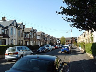
Jordanhill is an affluent area of the West End of the city of Glasgow, Scotland. The area consists largely of terraced housing dating from the early to mid 20th century, with some detached and semi-detached homes and some modern apartments.

<span class="mw-page-title-main">Scotstoun</span> Human settlement in Scotland

Scotstoun is an area of Glasgow, Scotland, west of Glasgow City Centre. It is bounded by Garscadden and Yoker to the west, Victoria Park, Jordanhill and Whiteinch to the east, Jordanhill to the north and the River Clyde to the south. At the heart of Scotstoun lies Scotstounhill, an enclave of late Victorian and post-war housing centred on Scotstounhill railway station. Scotstoun is home to BAE Systems Surface Ships, and to the Glasgow Warriors rugby team.

<span class="mw-page-title-main">Knightswood</span> Human settlement in Scotland

Knightswood is a suburban district in Glasgow, containing three areas: Knightswood North or High Knightswood, Knightswood South or Low Knightswood, and Knightswood Park. It has a golf course and park, and good transport links with the rest of the city. Garscadden and Scotstounhill railway stations serve Low Knightswood while Westerton station serves High Knightswood. Knightswood is directly adjoined by the Anniesland, Blairdardie, Drumchapel, Garscadden, Jordanhill, Netherton, Scotstoun, Scotstounhill and Yoker areas of Glasgow, and by Bearsden in the north.

<span class="mw-page-title-main">North Clyde Line</span> Railway line in Glasgow City, Scotland, UK

The North Clyde Line is a suburban railway in West Central Scotland. The route is operated by ScotRail Trains. As a result of the incorporation of the Airdrie–Bathgate rail link and the Edinburgh–Bathgate line, this route has become the fourth rail link between Glasgow and Edinburgh.

<span class="mw-page-title-main">Kelvindale</span> Human settlement in Scotland

Kelvindale is a district in the West End of the city of Glasgow, Scotland. Kelvindale shares the G12 postcode with the neighbouring residential districts of Kelvinside, Hillhead, Hyndland, Dowanhill, as well as Gartnavel General Hospital, Glasgow Clyde College (Anniesland) and the University of Glasgow, and is also close to the Anniesland and Wyndford areas of the city. The area is characterised by traditional interwar housing, formed of tenements and semi-detached houses.

<span class="mw-page-title-main">Hyndland</span> Human settlement in Scotland

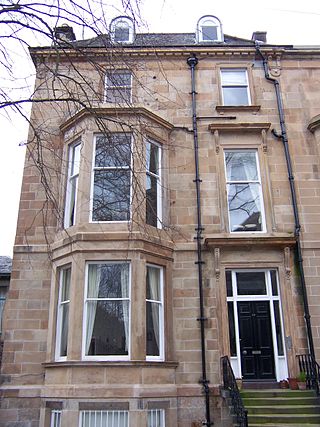
Hyndland is a residential area in the West End of the city of Glasgow, Scotland.

<span class="mw-page-title-main">Anniesland</span> District in Glasgow, Scotland

Anniesland is a district in the West End of the Scottish city Glasgow. It is situated north of the River Clyde, and centres on the major road junction of the Great Western Road (A82) and Crow Road/Bearsden Road (A739), known as Anniesland Cross.

<span class="mw-page-title-main">Kelvinside</span> Human settlement in Scotland

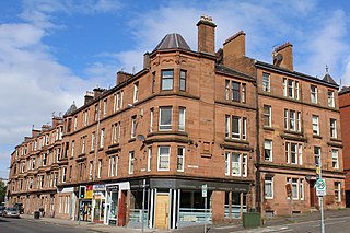
Kelvinside is a district in the Scottish city of Glasgow. It is situated north of the River Clyde and is bounded by Broomhill, Dowanhill and Hyndland to the south with Kelvindale and the River Kelvin to the north. It is an affluent area of Glasgow, with large Victorian villas and terraces.

<span class="mw-page-title-main">Whiteinch</span> Human settlement in Scotland

Whiteinch is an area in the city of Glasgow, Scotland. It is situated directly north of the River Clyde, between the Partick and Scotstoun areas of the city. Whiteinch was at one stage part of the burgh of Partick, until that burgh's absorption into the expanding city of Glasgow in 1912, and part of the Parish of Govan.

<span class="mw-page-title-main">Hyndland railway station</span> Railway station in Glasgow, Scotland

Hyndland railway station serves Hyndland in Glasgow, Scotland. The station is 3+14 miles (5.2 km) west of Glasgow Central and 2+34 miles (4.4 km) west of Glasgow Queen Street on the Argyle and North Clyde Lines. It is managed by ScotRail.

<span class="mw-page-title-main">Jordanhill railway station</span> Railway station in Glasgow, Scotland

Jordanhill railway station is a side-platformed suburban railway station in the Jordanhill area in the West End of Glasgow, Scotland. The station, which is governed by Transport Scotland and managed by ScotRail, lies on the Argyle Line and the North Clyde Line. In operation since 1887, the station stemmed losses for an area that was in decline.

The Stobcross Railway was a railway line in Glasgow, Scotland, built by the North British Railway to connect from Maryhill to the new dock being built at Stobcross; the dock became the Queen's Dock, opened in 1877. The line was opened first, in 1874, and gave the North British company access to the north bank of the River Clyde; there was a goods depot at Partick.

<span class="mw-page-title-main">Victoria Park, Glasgow</span>

Victoria Park is a 20-hectare (50-acre) park located in the west of Glasgow, Scotland, adjacent to the districts of Scotstoun, Whiteinch, Jordanhill and Broomhill. The park was created and named for Queen Victoria's jubilee in 1887. The main entrances to the park are from Westland Drive, Victoria Park Drive North, and Balshagray Avenue. The Friends of Victoria Park (FoVP) is a West Glasgow group set up to protect and develop Victoria Park.

<span class="mw-page-title-main">Hyndland Secondary School</span> State comprehensive school in Glasgow, Scotland

Hyndland Secondary School is a non-denominational state comprehensive school in the Hyndland area of Glasgow, Scotland.

<span class="mw-page-title-main">Thornwood, Glasgow</span> Human settlement in Scotland

Thornwood is a largely residential area of Glasgow, Scotland, lying north of the River Clyde. Part of the city's West End, it is situated almost on the river between Partick to the east and south and Broomhill to the north and west; the neighbourhoods of Whiteinch, Glasgow Harbour and Hyndland are also fairly close.

<span class="mw-page-title-main">St Bride's Church, Glasgow</span> Church in Glasgow, Scotland

St Bride's Episcopal Church is situated in the Hyndland area of the West End of Glasgow, Scotland.

<span class="mw-page-title-main">Victoria Park (ward)</span> Human settlement in Scotland

Victoria Park is one of the 23 wards of Glasgow City Council. Created as Partick West in 2007 it returned four council members, using the single transferable vote system; the boundaries were unchanged in 2012. For the 2017 Glasgow City Council election, the boundaries were changed, the ward decreased in size and population, was re-named Victoria Park and returned three members.

References

  1. Glasgow's Crosses, Glasgow History, 28 May 2016
  2. Centre Info, Broomhill Square Shopping Centre
  3. About Broomhill Sports Club, Broomhill Sports Club (archived version, 2016
  4. Home, BSC Glasgow
  5. About, The Edge Gym
  6. About Our Club, Jordanhill Bowling Club
  7. About, Broomhill Lawn Tennis & Squash Club
  8. About Us, Broomhill Hyndland Parish Church
  9. About Us, 130th Glasgow Boys Brigade
  10. Location, 101st Glasgow Boys Brigade
  11. About Us, Balshsgray Victoria Park Church of Scotland
  12. Our Lady of Perpetual Succour, Archdiocese of Glasgow directory
  13. £15m upgrade will make homes best in the West, Evening Times, 27 September 2013