Deaconsbank

Last updated

Deaconsbank
Deaconsbank at Inverewe.jpg
The road entrance to the Inverewe phase of Deaconsbank from the A727
Glasgow UK location map.svg
Red pog.svg
Deaconsbank
East Renfrewshire UK location map.svg
Red pog.svg
Deaconsbank
Location within Glasgow
Glasgow UK location map.svg
Red pog.svg
Deaconsbank
Deaconsbank (Glasgow council area)
OS grid reference NS540584
Council area
Lieutenancy area
  • Glasgow
Country Scotland
Sovereign state United Kingdom
Post town GLASGOW
Postcode district G46
Dialling code 0141
Police Scotland
Fire Scottish
Ambulance Scottish
UK Parliament
Scottish Parliament
List of places
UK
Scotland
Glasgow
55°47′50″N4°19′49″W / 55.7973°N 4.3304°W / 55.7973; -4.3304 Coordinates: 55°47′50″N4°19′49″W / 55.7973°N 4.3304°W / 55.7973; -4.3304

Deaconsbank is a neighbourhood in the Scottish city of Glasgow. It is situated south of the River Clyde. The main feature of the area, which falls into the Greater Pollok ward of Glasgow City Council and directly borders the East Renfrewshire council region, [1] is an estate of around 639 private houses built in the late 1970s by Barratt Developments, prior to which the area was open farmland. [2] Deaconsbank is bordered by the M77 motorway to the west and by Rouken Glen Park and golf course to the east. The northern parts of the suburban town of Newton Mearns are a short distance to the south, as is Patterton railway station.

Contents

Residential areas

Deaconsbank is divided into three housing stages that were constructed one after the other. There is no direct road connectivity between these phases; only walkways are available. The streets in each phase all share the phase's name as the first part of the name. The first phase to be built was Inverewe off Nitshill Road A727 (named after a location near Loch Ewe (north of Torridon), it is the smallest of the three phases). Phase two was Loganswell, again off Nitshill Road, built adjoining from the Jenny Lind area constructed decades earlier (Loganswell may have been named after a small hamlet in nearby East Renfrewshire). The last and largest phase built was Invergarry (named after a location in Glen Garry near Loch Oich), this time off Stewarton Road B769

Deaconsbank has for many years had an active residents association, [3] as required by the Title Deeds. The primary purpose of the association is to maintain the "common or amenity ground", which totals about 27 acres in both large and small pieces of largely grassland.

New adjoining housing developments

In recent years more housing (Thistlebank and Mearns Grove) has been built to the south of Invergarry heading towards Newton Mearns; [4] in a nod to the existing housing estate it adjoined, the streets in Thistlebank are named after Deaconsbank.

History

Map showing the Deaconsbank area (bottom left) adjacent to the golf course of the same name in early 1900s TBGiffMap1923.jpg
Map showing the Deaconsbank area (bottom left) adjacent to the golf course of the same name in early 1900s

The name Deaconsbank is taken from the former nearby Deacons Bank Farm beside the Auldhouse Burn which flows through what is now the modern day Rouken Glen park. [5] Before housing was constructed in the area that was to bear the name of the farm, the land there was also primarily used for agriculture and both areas were part of the Maxwell family's Pollok Estate. The area was described in the sale documents as "Darnley Park" and an area of land which is located between present day Deaconsbank and Jenny Lind, titled 'The Clogholes' [6] both hang in Pollok House, the ancestral home of the Maxwell family. Both works are watercolours painted in 1830 by an unknown artist working for the Maxwell family and are part of a larger series depicting parts of their vast estate.

During World War II, the land beside Deaconsbank and Patterton was used as a prisoner-of-war camp. Specifically, the area of housing called Thistlebank, immediately to the south of Invergarry Drive, and with its main street called Deaconsbank Avenue, shows on maps as having been exactly the site of what may have been an army camp which was then used as a prisoner of war (PoW) camp. In recent years before the construction of more housing, archaeological evaluation and recording work in connection with the prisoner of war camp took place; it appears to have been the first piece of archaeological work on a PoW camp in Scotland, and camp remains are now in the care of Glasgow City Council who have made provision for the enhancement and maintenance of the objects. [7] [8]

Sports

Deaconsbank also is the name of the golf course to the east of Stewarton Road adjacent to Invergarry and Thistlebank adjoining Rouken Glen Park (part of a David Lloyd Leisure club), [9] at the southern extremity of which (close to the Neilston branch railway line) is a 16th century circular dovecote. [10]

Before relocating to Newton Mearns, Deaconsbank was also home to Whitecraigs Rugby Club [11] with their ground adjoining Invergarry. The land has since been used for Whitecraigs Care Home and more housing.

Transport

Related Research Articles

<span class="mw-page-title-main">East Renfrewshire</span> Council area of Scotland

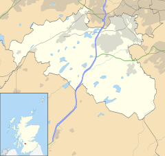
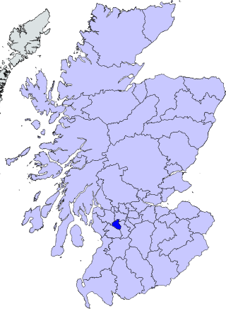
East Renfrewshire is one of 32 council areas of Scotland. Until 1975, it formed part of the county of Renfrewshire for local government purposes along with the modern council areas of Renfrewshire and Inverclyde. These three council areas together still form a single lieutenancy area called Renfrewshire.

<span class="mw-page-title-main">Nitshill</span> Human settlement in Scotland

Nitshill is a district on the south side of Glasgow. It is bordered by South Nitshill to the south, Darnley to the east, Crookston and Roughmussel to the north-west, Hurlet to the west and Househillwood and Priesthill to the north, with the Pollok district and the Silverburn Centre beyond. An area of open ground to the south-west of Nitshill forms the boundary between Glasgow and the town of Barrhead in East Renfrewshire.

<span class="mw-page-title-main">Pollok</span> Human settlement in Scotland

Pollok is a large housing estate on the south-western side of the city of Glasgow, Scotland. The estate was built either side of World War II to house families from the overcrowded inner city. Housing 30,000 at its peak, its population has since declined due to the replacement of substandard housing with lower-density accommodation. As of 2021, the population was recorded at 81,951 people.

<span class="mw-page-title-main">Eastwood, Strathclyde</span>

Eastwood is a civil parish which straddles Glasgow and East Renfrewshire in Scotland. The parish has had no administrative functions since 1930, but is still used for some statistical purposes. From 1975 until 1996 the name was also used for a local government district in the Strathclyde region. The district covered the part of Eastwood parish outside the city of Glasgow plus adjoining areas to the south. The district was abolished in 1996 to become part of East Renfrewshire.

<span class="mw-page-title-main">Newton Mearns</span> Town in Scotland

Newton Mearns is a suburban town and the largest settlement in East Renfrewshire, Scotland. It lies 7 miles (11 km) southwest of Glasgow City Centre on the main road to Ayrshire, 410 feet (125 m) above sea level. It has a population of approximately 26,993, stretching from Whitecraigs and Kirkhill in the northeast to Maidenhill in the southeast, to Westacres and Greenlaw in the west and Capelrig/Patterton in the northwest.

<span class="mw-page-title-main">Giffnock</span> A town in East Renfrewshire, Scotland

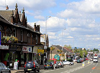
Giffnock is a town and the administrative centre of East Renfrewshire in the Central Lowlands of Scotland.

<span class="mw-page-title-main">Southpark Village</span> Human settlement in Scotland

Southpark Village is a housing estate in the Darnley area of the Scottish city of Glasgow. The northwestern area was built during the mid to late 1980s, but the southeastern part was built in the late 2010s. It is located on the south-western edge of the city, close to the towns of Barrhead and Newton Mearns in East Renfrewshire. Nearby areas within Glasgow itself are the rest of Darnley to the north, Deaconsbank to the east, and Parkhouse to the northwest, although Southpark is physically separated from all but the rest of Darnley by the Dams to Darnley Country Park and M77 motorway.

<span class="mw-page-title-main">Robert Pollok</span> Scottish poet

Robert Pollok was a Scottish poet best known for his work, The Course of Time, published in the year of his death.

<span class="mw-page-title-main">Crookston, Glasgow</span> Suburb of Glasgow, Scotland

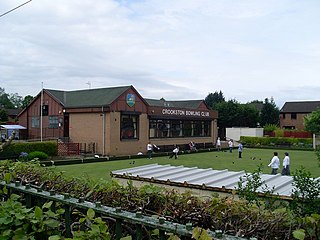
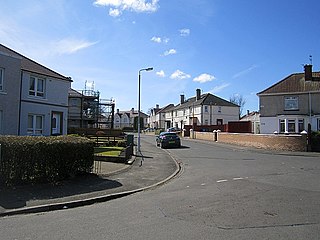
Crookston is a residential suburb on the southwestern edge of the city of Glasgow, Scotland.

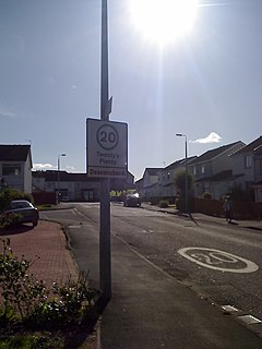
Arden is a medium-sized housing estate on the south-western edge of the city of Glasgow, Scotland. The M77 motorway runs directly to the west of the neighbourhood, with Junction 3 serving the area; a small industrial estate is located to the south-east. The residential area of Carnwadric is to the north-east of Arden, and the Jenny Lind part of Deaconsbank to the south, while the land to the north is open ground and woodland.

<span class="mw-page-title-main">South Nitshill</span> Human settlement in Scotland

South Nitshill is a neighbourhood in the Scottish city of Glasgow. It is situated south of the River Clyde, in the south-west of the conurbation and within the Greater Pollok ward of the local authority area. All streets in the area have names beginning with 'W'.

Mansewood is a residential district in the Scottish city of Glasgow. It is situated south of the River Clyde and is surrounded by the districts of Eastwood, Hillpark, Pollokshaws in Glasgow, and Thornliebank and Giffnock in East Renfrewshire.

<span class="mw-page-title-main">Whitecraigs railway station</span> Railway station in East Renfrewshire, Scotland, UK

Whitecraigs railway station is a railway station serving the Whitecraigs and Davieland areas of the towns of Giffnock and Newton Mearns, East Renfrewshire, Greater Glasgow, Scotland. The station is managed by ScotRail and lies on the Neilston branch of the Cathcart Circle 6+34 miles (10.9 km) southwest of Glasgow Central. The line here forms the boundary which separates Newton Mearns and Giffnock across Ayr Road.

<span class="mw-page-title-main">A726 road</span> Road in Scotland

The A726 road in Scotland is a major route with several distinct sections with different characteristics and names; owing to its stages of construction, since 2005 it has two separate parts, the first running between Strathaven in South Lanarkshire and Junction 5 of the M77 motorway south of Newton Mearns in East Renfrewshire via East Kilbride, and the other running between Junction 3 of the M77 and the M898 motorway near the Erskine Bridge, via Paisley and Junction 29 of the M8 motorway near Glasgow International Airport.

<span class="mw-page-title-main">Jenny Lind, Glasgow</span> Human settlement in Scotland

Jenny Lind is a small neighbourhood in the Scottish city of Glasgow. It is situated south of the River Clyde, contiguous with the larger Deaconsbank neighbourhood and across a dual carriageway from the Arden and Thornliebank Industrial Estate. It was extended slightly in the 21st century by the addition of Jenny Lind Court. Jenny Lind falls under the Glasgow City Council Greater Pollok ward and has a short border with Deaconsbank Golf Club and Rouken Glen Park in the East Renfrewshire council region.

<span class="mw-page-title-main">A727 road</span> Road in Scotland

The A727 road in Scotland runs from East Kilbride in South Lanarkshire, through East Renfrewshire, to Junction 3 of the M77 motorway in Glasgow.

<span class="mw-page-title-main">Parkhouse, Glasgow G53</span> Human settlement in Scotland

Parkhouse is a residential neighbourhood of Glasgow, Scotland close to the border with East Renfrewshire. It is located on the south-western edge of the city, close to the towns of Barrhead and Newton Mearns in East Renfrewshire. Within the G53 postcode area and the Greater Pollok ward of the Glasgow City Council administration, the eastern cluster of private housing was constructed in the 1980s and the western part in the 2010s, prior to which it was open farmland annexed to Glasgow in 1938.

<span class="mw-page-title-main">Dams to Darnley Country Park</span>

Dams to Darnley Country Park is a 1350 acre country park in East Renfrewshire and Glasgow, in Scotland comprising the historic greenspace between the towns of Barrhead and Newton Mearns in East Renfrewshire, and the areas of Darnley, Parkhouse and Southpark Village in south Glasgow. Being designated since 2000, it is one of the newest country parks in Scotland.

<span class="mw-page-title-main">Eastwood, Glasgow</span> Human settlement in Scotland

Eastwood is a residential neighbourhood in the city of Glasgow, Scotland. It is situated south of the River Clyde, and is part of the Newlands/Auldburn ward under Glasgow City Council.

<span class="mw-page-title-main">Househillwood</span> Area of Glasgow

Househillwood is a residential neighbourhood of Glasgow, Scotland, situated in the south-west of the city.

References

  1. "Registers of Scotland. Publications, leaflets, Land Register Counties". Archived from the original on 7 July 2013. Retrieved 2013-07-13.
  2. Nitshill and Arden (West of Scotland Archaeology Service, 1959), The Glasgow Story
  3. Deaconsbank residents association GreaterPollok.net
  4. Deaconsbank, Miller Homes [new housing developments adjoining Deaconsbank]
  5. Deacons Bank, the Glasgow Story
  6. 'The Clogholes', The Glasgow Story]
  7. Deaconsbank at Online Archaeology
  8. Annual Report of the West of Scotland Archaeology Service 2005/06
  9. Golf, David Lloyd Glasgow Rouken Glen
  10. Thornliebank, Holm Farm, Dovecot, Canmore
  11. History, Whitecraigs Rugby Club