Hutchesontown

Last updated

Hutchesontown
East Glasgow from the air (geograph 5374196) (cropped).jpg
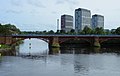
Aerial photo of Hutchesontown on the south bank of the River Clyde (with Calton and Glasgow Green on the north bank)
Glasgow UK location map.svg
Red pog.svg
Hutchesontown
Location within Glasgow
OS grid reference NS594636
Council area
Lieutenancy area
  • Glasgow
Country Scotland
Sovereign state United Kingdom
Post town GLASGOW
Postcode district G5 0
Dialling code 0141
Police Scotland
Fire Scottish
Ambulance Scottish
UK Parliament
Scottish Parliament
List of places
UK
Scotland
Glasgow
55°50′50″N4°14′38″W / 55.847119°N 4.243909°W / 55.847119; -4.243909

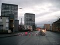
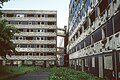
Hutchesontown is an inner-city area in Glasgow, Scotland. Mostly residential, it is situated directly south of the River Clyde and forms part of the wider historic Gorbals district, which is covered by the Southside Central ward under Glasgow City Council.

Contents

The area is linked to Glasgow Green public park on the north side of the river by St. Andrew's Suspension Bridge and King's Bridge. At its north-western edge, Albert Bridge is the closest crossing point towards Glasgow city centre. In McNeill Street, Hutchesontown has one of Glasgow's original Carnegie libraries, deftly designed by the Inverness-born architect James Robert Rhind. James Stokes, recipient of the Victoria Cross, was from the area.

Comprehensive Development Area

Following the Second World War, Hutchesontown was declared a Comprehensive Development Area (CDA) in 1957, in the aftermath of the Bruce Report. [1] [2] This called for the mass gentrification of the area which took the form of slum clearance and the replacement of overcrowded, insanitary tenement housing with new homes in high rise tower blocks. [3] The area became almost unrecognisable from its previous appearance, with blocks of tenements swept away along with several Victorian and Edwardian-era churches and civic buildings which in later times would have been considered to be of architectural merit. [4]

Hutchesontown was, in effect, used as a testing ground for similar schemes around the city. It was decided to divide the area into five "zones" which were given to different architects to implement a mixture of different schemes.

See also

Related Research Articles

The Gorbals is an area in the city of Glasgow, Scotland, and former burgh, on the south bank of the River Clyde. By the late 19th century, it had become densely populated; rural migrants and immigrants were attracted by the new industries and employment opportunities of Glasgow. At its peak, during the 1930s, the wider Gorbals district had swollen in population to an estimated 90,000 residents, giving the area a very high population density of around 100,000 per sq. mi. (40,000/km2). Redevelopment after WWII has taken many turns, and the area's population is substantially smaller today. The Gorbals was also home to 16 high rise flat blocks; only six are standing as of 2024, and two of them are set to come down in the next couple of years.

<span class="mw-page-title-main">Pollokshaws</span> Human settlement in Scotland

Pollokshaws is an area on the South side of the city of Glasgow, Scotland. It is bordered by the residential neighbourhoods of Auldhouse to the east, Eastwood and Hillpark to the south and Shawlands to the north, with the Glasgow South Western Line railway and the open lands of Pollok Country Park to the west. The White Cart Water flows through the area.

<span class="mw-page-title-main">Castlemilk</span> Human settlement in Scotland

Castlemilk is a district of Glasgow, Scotland. It lies to the far south of the city centre, adjacent to the Croftfoot and Simshill residential areas within the city to the north-west, the town of Rutherglen - neighbourhoods of Spittal to the north-east and Fernhill to the east, Linn Park and its golf course to the west, and the separate village of Carmunnock further south across countryside.

<span class="mw-page-title-main">Townhead</span> Human settlement in Scotland

Townhead is a district within the city of Glasgow, Scotland. It is one of Glasgow's oldest areas, and contains two of its major surviving medieval landmarks – Glasgow Cathedral and the Provand's Lordship.

Sir Robert Hogg Matthew, OBE FRIBA FRSE was a Scottish architect and a leading proponent of modernism.

<span class="mw-page-title-main">Toryglen</span> Human settlement in Scotland

Toryglen is a district in southern Glasgow, Scotland, falling within the Langside ward under Glasgow City Council. It is approximately two miles south of the city centre, bounded to the west by Mount Florida, the north-west by Polmadie, to the north-east by the West Coast Main Line railway and the M74 motorway the south by King's Park, and immediately to the east by the town of Rutherglen.

Cranhill is an inner city district and housing scheme in the north east of Glasgow, Scotland. Cranhill was developed from public funding in the early 1950s and was originally, chiefly composed of four-storey tenement blocks surrounding a patch of grassland, which became Cranhill Park. Later development saw the building of three tower blocks, surrounded by rows of terraced maisonettes. In more recent years, a number of semi-detached and detached homes have been built. The area also hosts some shops, two primary schools and nurseries, a community centre and the Cranhill water tower.

<span class="mw-page-title-main">Sandyhills</span> Human settlement in Scotland

Sandyhills is an area of the Scottish city of Glasgow. It is situated north of the River Clyde and has fallen within the Shettleston ward of Glasgow City Council since 2007.

Sighthill is a neighbourhood in the Scottish city of Glasgow. It is situated north of the River Clyde and is part of the wider Springburn district in the north of the city. It is bordered to the north by Cowlairs, to the east by the Springburn Bypass road and the Royston neighbourhood, to the west by the Glasgow to Edinburgh via Falkirk Line and to the south by the Townhead interchange of the M8 Motorway.

<span class="mw-page-title-main">Oatlands, Glasgow</span> Human settlement in Scotland

Oatlands is an area in the city of Glasgow, Scotland. It is situated south of the River Clyde, falls within the Southside Central ward under Glasgow City Council, and is part of the Gorbals historic area. Its boundaries are Hutchesontown and the Southern Necropolis cemetery to the west, Polmadie to the south, Shawfield to the east, and Glasgow Green public park to the north.

<span class="mw-page-title-main">Laurieston, Glasgow</span> Human settlement in Scotland

Laurieston is a district in the Gorbals area of the Scottish city of Glasgow. It is situated south of the River Clyde. It derives its name from James Laurie who, along with his brother, developed a large part of the district in the early 19th century.

Braidfauld is a small area of Glasgow, Scotland which is in the East End of the city slightly north of the River Clyde and south of the Tollcross area. It was also the name of the 45th ward of Glasgow City Council, prior to the re-organisation into multi-member wards in 2007.

The Bruce Report is the name commonly given to the First Planning Report to the Highways and Planning Committee of the Corporation of the City of Glasgow published in March 1945. It influenced an intensive programme of regeneration and rebuilding efforts which took place in the city and surroundings from the mid-1950s and lasted until the late 1970s. The author was Robert Bruce, Glasgow Corporation Engineer at the time.

<span class="mw-page-title-main">Red Road Flats</span> Former high-rise housing complex in Glasgow, Scotland

The Red Road Flats were a mid-twentieth-century high-rise housing complex located between the districts of Balornock and Barmulloch in the northeast of the city of Glasgow, Scotland. The estate originally consisted of eight multi-storey blocks of steel frame construction. All were demolished by 2015. Two were "slabs", much wider in cross-section than they are deep. Six were "points", more of a traditional tower block shape. The slabs had 28 floors, the point blocks 31, and taken together, they were designed for a population of 4,700 people. The point blocks were among the tallest buildings in Glasgow at 89 metres (292 ft), second in overall height behind the former Bluevale and Whitevale Towers in Camlachie. The 30th floor of the point blocks were the highest inhabitable floor level of any building in Glasgow.

<span class="mw-page-title-main">Hutchesontown C</span> Architectural structure in Glasgow City, Scotland, UK

Hutchesontown C was a Comprehensive Development Area (CDA) of an area of Hutchesontown, a district in the city of Glasgow, Scotland. Its centrepiece were two Brutalist 20-storey slab blocks at 16-32 Queen Elizabeth Square, designed by Sir Basil Spence and containing 400 homes. Acclaimed by architects and modernists, the flats became riddled with damp and infestations, which could not be cured even with a major renovation in the late 1980s. They were demolished in 1993, with the demolition contractor using twice the amount of explosive necessary to destroy the building, killing a female spectator in the process.

<span class="mw-page-title-main">Bluevale and Whitevale Towers</span> Residential in Scotland

The Bluevale and Whitevale Towers were twin tower block flats situated in the Camlachie district within the East End of Glasgow, Scotland. Officially named 109 Bluevale Street and 51 Whitevale Street, and often nicknamed the Gallowgate Twins or the Camlachie Twin Towers, the two towers were for a time the tallest buildings in Scotland.

<span class="mw-page-title-main">Housing in Glasgow</span> Overview of housing in Glasgow, Scotland

Glasgow, the largest city in Scotland, has several distinct styles of residential buildings. Building styles reflect historical trends, such as rapid population growth in the 18th and 19th centuries, deindustrialisation and growing poverty in the late 20th century, and civic rebound in the 21st century.

The 1950s and 1960s saw the construction of numerous brutalist apartment blocks in Sheffield, England. The Sheffield City Council had been clearing inner-city residential slums since the early 1900s. Prior to the 1950s these slums were replaced with low-rise council housing, mostly constructed in new estates on the edge of the city. By the mid-1950s the establishment of a green belt had led to a shortage of available land on the edges of the city, whilst the government increased subsidies for the construction of high-rise apartment towers on former slum land, so the council began to construct high-rise inner city estates, adopting modernist designs and industrialised construction techniques, culminating in the construction of the award-winning Gleadless Valley and Park Hill estates.

<span class="mw-page-title-main">Moorepark, Glasgow</span> Area of Glasgow, Scotland

Moorepark is a small area in the Scottish city of Glasgow. Situated south of the River Clyde and part of the former Burgh of Govan, it was colloquially referred to as 'Wine Alley' during the mid-to-late 20th century when a housing scheme with a rough reputation was sited there. It is now an industrial estate.

References

  1. Hutchesontown Housing (Glasgow City Archives, Department of Architectural and Civic Design, 1961), The Glasgow Story
  2. Lecture: Unbuilt Glasgow – The History & Impact of the Bruce Report, Fergus Sutherland & David Martin, Glasgow City Heritage Trust, 15 March 2017
  3. 1 2 3 4 Hutchesontown: Housing, Everyday Life & Wellbeing over the long term, University of Glasgow
  4. 1 2 3 4 5 6 Hutchesontown Gorbals - Architecture and History, Scotcities
  5. "Tower Block UK: Hutchesontown-Gorbals CDA Area B". University of Edinburgh . Retrieved 13 January 2019.
  6. 1 2 3 4 "Buildings in Glasgow: Hutchesontown-Gorbals". Emporis. Archived from the original on 28 February 2019. Retrieved 27 February 2019.
  7. "Tower Block UK: Hutchesontown-Gorbals CDA Area C". University of Edinburgh . Retrieved 13 January 2019.
  8. "Woman dies in demolition blast". The Herald. 13 September 1993. Retrieved 17 February 2019.
  9. Hutchesontown C: it went down with a bang and took a human life with it, Abandoned Spaces, 4 June 2018
  10. Hutchesontown / Gorbals Area D, Dictionary of Scottish Architects
  11. "Tower Block UK: Hutchesontown-Gorbals CDA Area D". University of Edinburgh . Retrieved 13 January 2019.
  12. "Two tower blocks are demolished". BBC News. 26 February 2006. Retrieved 17 February 2019.
  13. 'I won't let them split us up': Friend's promise to Gorbals neighbour as demolition looms, Glasgow Times, 26 November 2020
  14. Glasgow high-rise tenants being moved from fire-risk flats set to get new homes, Glasgow Live, 22 November 2021
  15. "Tower Block UK: Hutchesontown-Gorbals CDA Area E". University of Edinburgh . Retrieved 13 January 2019.
  16. McLean, David (13 April 2022). "The notoriously dire Gorbals flats that locals dubbed 'The Dampies'". GlasgowLive . Retrieved 26 July 2023.
  17. Wright, Valerie (December 2021). "'Housing Problems … are Political Dynamite': Housing Disputes in Glasgow c. 1971 to the Present Day". Sociological Research Online. 26 (4): 976–988. doi:10.1177/1360780418780038. hdl: 1893/30642 .
  18. Double demolition for Glasgow Gorbals tower blocks, BBC News, 21 July 2013