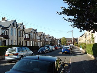
Jordanhill is an affluent area of the West End of the city of Glasgow, Scotland. The area consists largely of terraced housing dating from the early to mid 20th century, with some detached and semi-detached homes and some modern apartments.

Scotstoun is an area of Glasgow, Scotland, west of Glasgow City Centre. It is bounded by Garscadden and Yoker to the west, Victoria Park, Jordanhill and Whiteinch to the east, Jordanhill to the north and the River Clyde to the south. At the heart of Scotstoun lies Scotstounhill, an enclave of late Victorian and post-war housing centred on Scotstounhill railway station. Scotstoun is home to BAE Systems Surface Ships, and to the Glasgow Warriors rugby team.

Knightswood is a suburban district in Glasgow, containing three areas: Knightswood North or High Knightswood, Knightswood South or Low Knightswood, and Knightswood Park. It has a golf course and park, and good transport links with the rest of the city. Garscadden and Scotstounhill railway stations serve Low Knightswood while Westerton station serves High Knightswood. Knightswood is directly adjoined by the Anniesland, Blairdardie, Drumchapel, Garscadden, Jordanhill, Netherton, Scotstoun, Scotstounhill and Yoker areas of Glasgow, and by Bearsden in the north.

Kelvindale is a district in the West End of the city of Glasgow, Scotland. Kelvindale shares the G12 postcode with the neighbouring residential districts of Kelvinside, Hillhead, Hyndland, Dowanhill, as well as Gartnavel General Hospital, Glasgow Clyde College (Anniesland) and the University of Glasgow, and is also close to the Anniesland and Wyndford areas of the city. The area is characterised by traditional interwar housing, formed of tenements and semi-detached houses.

Pollokshields is an area in the Southside of Glasgow, Scotland. Its modern boundaries are largely man-made, being formed by the M77 motorway to the west and northwest with the open land of Pollok Country Park and the Dumbreck neighbourhood beyond, by the Inverclyde Line railway and other branches which separate its territory from the largely industrial areas of Kinning Park, Kingston and Port Eglinton, and by the Glasgow South Western Line running from the east to south, bordering Govanhill, Strathbungo, Crossmyloof and Shawlands residential areas. There is also a suburban railway running through the area.

Glasgow North West was a constituency of the House of Commons of the Parliament of the United Kingdom (Westminster). It was first used at the 2005 general election and was abolished at the 2024 election, being replaced by Glasgow West.
Cranhill is an inner city district and housing scheme in the north east of Glasgow, Scotland. Cranhill was developed from public funding in the early 1950s and was originally, chiefly composed of four-storey tenement blocks surrounding a patch of grassland, which became Cranhill Park. Later development saw the building of three tower blocks, surrounded by rows of terraced maisonettes. In more recent years, a number of semi-detached and detached homes have been built. The area also hosts some shops, two primary schools and nurseries, a community centre and the Cranhill water tower.

Temple is a neighbourhood of Glasgow located in the north of the city, bounded by Anniesland to the south, Knightswood to the west and Kelvindale to the east; Netherton lies to the north. Temple appears in Joan Blaeu's 1662 Atlas of Scotland and many subsequent maps.

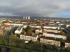
Anniesland is a district in the West End of the Scottish city Glasgow. It is situated north of the River Clyde, and centres on the major road junction of the Great Western Road (A82) and Crow Road/Bearsden Road (A739), known as Anniesland Cross.

Milton is a district in the Scottish city of Glasgow, situated north of the River Clyde. The housing scheme is about 2+1⁄2 miles north of Glasgow City Centre and forms part of the northern edge of the city's urban area.
Glasgow Anniesland was a burgh constituency represented in the House of Commons of the Parliament of the United Kingdom from 1997 until 2005, when it was replaced by the larger Glasgow North West, with the exception of Kelvindale which joined Glasgow North.

Anniesland Court is a 22-storey residential tower block in the Anniesland area of Glasgow, Scotland, designed by J Holmes & Partners and completed in 1968. It is the tallest listed building in Scotland, and is remarkably similar to Ernő Goldfinger's later and more famous Trellick Tower in London. It is the only tower block in Glasgow to have been granted a category A listing.

Glasgow Anniesland is a constituency of the Scottish Parliament (Holyrood). It is one of eight constituencies within the Glasgow City council area. It elects one Member of the Scottish Parliament (MSP) by the plurality method of election. It is also one of nine constituencies in the Glasgow electoral region, which elects seven additional members, in addition to nine constituency MSPs, to produce a form of proportional representation for the region as a whole.
The Stobcross Railway was a railway line in Glasgow, Scotland, built by the North British Railway to connect from Maryhill to the new dock being built at Stobcross; the dock became the Queen's Dock, opened in 1877. The line was opened first, in 1874, and gave the North British company access to the north bank of the River Clyde; there was a goods depot at Partick.

Elections to Glasgow City Council were held on 3 May 2007, the same day as the other Scottish local government elections and the Scottish Parliament general election. The election was the first one using 21 new wards created as a result of the Local Governance (Scotland) Act 2004, each ward elected three or four councillors using the single transferable vote system form of proportional representation. The new wards replaced 79 single-member wards which used the plurality system of election. It also saw the election of Glasgow's first councillors for the Scottish Greens and for Solidarity.

Drumry is a district in the Scottish town of Clydebank, West Dunbartonshire, split into North and South Drumry by its main thoroughfare, Drumry Road. Some of the housing, including five tower blocks, was refurbished in the early 2010s.

Netherton is a district of Glasgow, in the north of the city, bounded by Temple to the south, Knightswood to the west while Westerton in Bearsden lies to the North and East. Netherton appears in Joan Blaeu's 1662 Atlas of Scotland and many subsequent old maps. It is currently not shown on Ordnance Survey maps greater than 1:25000 scale. The street was founded in around the 1930s. It is a street close by local shops, the hut, and a park district. Part of the city council.

Anne Margaret McTaggart is a Scottish National Party (SNP) politician, and a Glasgow city councillor. She was previously a Scottish Labour Member of the Scottish Parliament (MSP) for the Glasgow region from 2011 to 2016.
Drumchapel/Anniesland is one of the 23 wards of Glasgow City Council. Since its creation in 2007 it has retained the same boundaries and returned four council members, using the single transferable vote system.