Crookston, Glasgow

Last updated

Crookston
Crookston Bowling Club - geograph.org.uk - 1318803.jpg
Crookston Bowling Club
Glasgow UK location map.svg
Red pog.svg
Crookston
Location within Glasgow
OS grid reference NS518636
Council area
Lieutenancy area
  • Glasgow
Country Scotland
Sovereign state United Kingdom
Post town GLASGOW
Postcode district G52 3 / G53 7
Dialling code 0141
Police Scotland
Fire Scottish
Ambulance Scottish
UK Parliament
Scottish Parliament
List of places
UK
Scotland
Glasgow
55°50′34″N4°22′06″W / 55.842780°N 4.368377°W / 55.842780; -4.368377

Crookston (Scottish Gaelic : Baile Cruic, Scots : Cruixtoun) is a residential suburb on the southwestern edge of the city of Glasgow, Scotland. [1]

Contents

Two distinct and geographically separate neighbourhoods about 1 mile (1.6 km) apart on opposite sides of the White Cart Water are known by the Crookston name, owing to factors in their development. Both areas share the same main road (A736 Crookston Road) and fall within the same U.K. and Scottish Parliamentary constituencies (as of 2019 boundaries), but the northern area falls under the Cardonald ward for Glasgow City Council and is within the G52 postcode zone, while the southern area is in the Greater Pollok ward and the G53 postcode zone.

History

Crookston Estate

The lands of Crookston were named after the feudal Anglo-Norman lord, Robert Croc who was granted the deeds by David I of Scotland, via Walter fitz Alan, [1] in 1170 and soon built Crookston Castle (Dùn Cruic in Scottish Gaelic) on a small knoll. [2] In addition to the first wooden version of the castle – John Stewart of Darnley had the surviving stone version built in around 1400 [3] – Robert Croc had a chapel constructed, [4] as well as a hospital, [5] [6] [7] [2] beginning a legacy of healthcare facilities in the area which continues to the present era.

View from Crookston Castle towards west Pollok, Leverndale and Crookston Road (2005) View from Crookston Castle - WSW - geograph.org.uk - 1084328.jpg
View from Crookston Castle towards west Pollok, Leverndale and Crookston Road (2005)

The area north of the castle, between the Levern Water and the White Cart Water, was forested and known as Crookston Wood (Iron Age remains were found there during a 1959 archaeological excavation), [8] while several farms surrounding the castle also shared the name: Crookston House and Farm to its west, Nether Crookston just to its south, Old Crookston further south and Mains of Crookston to its east. [9] The castle was captured in the mid-1500s [3] and its importance diminished, although it was restored in the mid-19th century by the Maxwells of Pollok [10] [11] and was donated by the family to the National Trust for Scotland in 1931, being the first property the organisation managed. [1]

Crookston Station area

Motor trading business on Paisley Road West, just within Glasgow at its boundary with Ralston, Renfrewshire Hillington Trade Centre - geograph.org.uk - 1188956.jpg
Motor trading business on Paisley Road West, just within Glasgow at its boundary with Ralston, Renfrewshire
Abandoned buildings (now converted to houses) and tracks at Crookston railway station (1986) Crookston station (remains) geograph-3117502-by-Ben-Brooksbank.jpg
Abandoned buildings (now converted to houses) and tracks at Crookston railway station (1986)
View of the White Cart Water at Howford Bridge from NCR 7 which runs beneath it Howford Bridge - geograph.org.uk - 1359756.jpg
View of the White Cart Water at Howford Bridge from NCR 7 which runs beneath it

Although other names such as Cardonald, Hillington, Ingleston, Ralston and Rosshill were associated with the territory north of the White Cart river, [1] in 1885 the Crookston name was still sufficiently prominent locally for it to be chosen as the name of a station on the Glasgow and South Western Railway's new route between Glasgow and Paisley – sited between the White Cart and the main road between the towns (A761 Paisley Road West), the tracks followed the trajectory of the abandoned Glasgow, Paisley and Johnstone Canal and was thus titled the Paisley Canal line). [1] [2] Over the next few decades, a small commuter suburb consisting mostly of large villas was constructed around the station, and inevitably this community became known as Crookston. [2]

After the lands, previously within the parish of Paisley Abbey, Renfrewshire, [1] [12] [13] were annexed by Glasgow Corporation in 1926, [14] [15] it was gradually surrounded by other residential neighbourhoods including South Cardonald, Hillington, Penilee and Rosshall within the city, [1] [2] also directly bordering the affluent suburb of Ralston, Renfrewshire. Several small developments of housebuilding took place within the area over various eras until almost all the land was built upon, ranging from concrete tenements, terraces of modest houses, semi-detached bungalows and flat-roofed apartment blocks, plus the converted buildings of the original station, which were abandoned after the line closed in 1983; [1] it re-opened in 1990, but now uses only one track and platform for both directions (a small section of double track to the east of Crookston allows trains to pass one another).

In addition to an eponymous hotel (extended from a villa) on Crookston Road, [1] [16] there is a good provision of local shops and other services, including churches on Paisley Road West, and bowling clubs to the east at Cardonald and the west at Ralston. One of the very few pre-railway era remnants in the area is Cardonald Place Farm; [1] a mill sited nearby was demolished in the 1930s. [1] The nearest primary schools are in South Cardonald, [17] as is the Catholic Lourdes Secondary School; the local nondenominational high school is Rosshall Academy, [17] built in 2001 immediately south of the Paisley Canal railway lines and next to Ross Hall Hospital and Rosshall Public Park, [1] [2] beyond which is the Howford Bridge, carrying the main road south over the White Cart. [1] [18] The local community council covering this area is South Cardonald and Crookston CC. [19]

Crookston Home and Leverndale area

In 1895, a lunatic asylum and hospital (known initially as Govan District Asylum, then as Hawkhead Asylum after the surrounding country estate on the periphery of Paisley) was built on a promontory near the left bank of the White Cart to the west of Crookston Road. [20] [1] [21] It was expanded several times, including the incorporation of the old Hawkhead mansion and a farm for use by inmates, [1] [22] [23] and was renamed Leverndale Hospital in 1964. [24] [25] In that period there was a separate Hawkhead Hospital located across fields to the west of Leverndale, [1] another psychiatric facility south of that at Dykebar Hospital, [20] and another hospital a short distance to the east at Cowglen. [21] New buildings closer to the main road were constructed in the 1990s, and in the 2000s the older units (including the Category A listed Towerview Unit  [ de ] were converted to private housing. [1] In 2011, a station for the Scottish Ambulance Service opened at the new Leverndale site, [26] followed in 2014 by the NHS West of Scotland Mother and Baby Unit (relocated from the Southern General Hospital). [27]

The former Towerview Unit [de] at Leverndale Hospital, now apartments Apartments, Leverndale Hospital (geograph 2368885).jpg
The former Towerview Unit  [ de ] at Leverndale Hospital, now apartments
Modern apartment block near Leverndale Apartments Leverndale Road (geograph 2848297).jpg
Modern apartment block near Leverndale

In 1906, Renfrewshire Combination Poorhouse was built near Old Crookston Farm to the east of Crookston Road. [28] It was later renamed as Crookston Home Poor Law Institution, before being reconfigured as a nursing home for the elderly in 1934. [29] [21] Four years later, a development of 'cottage homes' (an early version of sheltered housing) was built immediately to its south, [28] [30] with additional care provided from the main block of the complex as required. [29] [21] [31] Around the same time, a wide area of land to the east and north of the Home (within Renfrewshire's Eastwood parish) [12] [32] was purchased by Glasgow from the Pollok Estate for housebuilding, and after its first stage (today's 'Old Pollok') was interrupted by World War II, [33] the large Pollok peripheral housing scheme was constructed along both banks of the Levern Water in the decade after the conflict, [34] surrounding Crookston Castle and also occupying part of the old woodland [35] and farms including Mains of Crookston, Byres, Nether Crookston and Crookston House – the latter, at the confluence of the White Cart and Levern Waters, [1] [36] became the site of Howford Special School in the mid-1960s. [1] [37] [38] [39]

In contrast to the preservation work at Leverndale, the Crookston Home facility operated until the 1990s when its functions became obsolete, [40] and the site was then cleared for housebuilding leaving no trace of the original buildings or the cottages. [21] [41] [42] There was already an existing mid-20th century development of houses at Roughmussel at the southern end of Crookston Road (along with a row of shops), and various housebuilders added clusters of suburban villas accessed from the main road from the 1990s until the 2010s, until most of the accessible land forming Glasgow's western border between Howford Bridge and Barrhead Road, a distance of over a mile, was built upon.

View of some of the older houses at the southern end of Crookston Road Houses on Crookston Road - geograph.org.uk - 1319341.jpg
View of some of the older houses at the southern end of Crookston Road
New housing under construction at Raeswood, 2016 New houses, Roughmussel (geograph 4947046).jpg
New housing under construction at Raeswood, 2016
Lidl at Dalmellington Road Crookston Lidl - geograph.org.uk - 1319354.jpg
Lidl at Dalmellington Road

Despite the large number of family homes, there are no primary schools in this area itself, [17] the closest being in west Pollok a short distance from each other, and another at a modern campus in Craigbank (Nitshill) – it incorporates the special educational needs base previously at Howford School, [43] the vacated building for which was subjected to arson in 2018. [44] The older local schoolchildren typically attend Rosshall Academy and Lourdes Secondary, although St Paul's High School is physically closer for many. [17]

This southern sector of Crookston has no official recognised centre, the closest equivalent arguably being the crossroads at Bullwood Drive and Dalmellington Road where there is a supermarket and chemist in addition to Crookston Medical Centre (built in 2000) [45] and Crookston Bowling Club, which has its origins in the 1940s as part of the recreational provision for workers at the Rolls-Royce factory in Hillington Industrial Estate. [46] There is a local Crookston Community Group based just east of Crookston Road, [47] but technically this falls under Pollok and is involved with providing support to deprived communities in the south-west of Glasgow, a socio-economic classification into which most of Pollok falls, but Crookston does not [48] – some very large and grand homes have been built, particularly around Leverndale. There is also a natural barrier between the areas for the most part, formed by Haugh Hill [49] and other elevated woodland (labelled as components of the 'Stirling Maxwell Forest Parks', a designation for the many green areas in and around the streets of Pollok, including old Crookston Wood). [50] Echoing the area's past, a new elderly care facility, Meadowburn Home, opened in 2019 [51] close to where Crookston Home had stood but on the Pollok side of these woods; another smaller home at Bonnyholm near Rosshall (replacing a primary school, in a part of north Pollok where most of the residences were rebuilt too) had opened in 2018. [52]

Most amenities are located in the centre of Pollok, including the modernised 'civic realm' with district library, health centre and sports centre, adjacent to the Silverburn Centre with various retail and dining options and a cinema. The local community council covering this area is Hurlet and Brockburn CC. [53]

Name

While the individual modern developments in this area have used various names in marketing and for their streets (Raeswood, Blacksey Burn, Langhaul, Castlewood, Leverndale, Bullwood, Parklands etc.), none have been adopted more widely as the common name for their community, with 'Crookston' used by the media in reports referring to events in all of its smaller parts. [54] [55] [56] No clarifying prefixes (Old/New, north–south) have ever been adopted in official contexts in relation to the distinct areas on either side of the railway and river, although their differing history and geography would justify the usage of such distinctions.

Transport

The First Glasgow number 3 bus service between Glasgow's West End, city centre, Silverburn and Govan runs the length of Crookston Road through both the northern and southern parts of the area. The number 9 service between Paisley and Glasgow runs via Paisley Road West. [57]

Trains from Crookston operate every half hour, or hourly on Sundays. The closest railway station to the southernmost parts is Nitshill, 1 mile (1.6 km) from the junction of Barrhead Road. That neighbourhood is also about the same distance from Junction 2 of the M77 motorway between Glasgow and Ayrshire, whereas the northern neighbourhood is slightly further from Junction 25 of the M8 motorway between Glasgow Airport and Edinburgh.

Notable people

Related Research Articles

<span class="mw-page-title-main">Cardonald</span> Suburb of Glasgow, Scotland

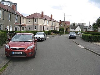
Cardonald is an outlying suburb of the Scottish city of Glasgow. Formerly a village in its own right, it lies to the southwest of the city and is bounded to the south by the White Cart Water. The area was part of Renfrewshire until 1926 when the villages of Cardonald, Crookston, Halfway and their surrounding farmland were annexed to Glasgow.

<span class="mw-page-title-main">Renfrewshire</span> Council area of Scotland

Renfrewshire is one of the 32 council areas of Scotland.

<span class="mw-page-title-main">Nitshill</span> Human settlement in Scotland

Nitshill is a district on the south side of Glasgow. It is bordered by South Nitshill to the south, Darnley to the east, Crookston and Roughmussel to the north-west, Hurlet to the west and Househillwood and Priesthill to the north, with the Pollok district and the Silverburn Centre beyond. An area of open ground to the south-west of Nitshill forms the boundary between Glasgow and the town of Barrhead in East Renfrewshire.

<span class="mw-page-title-main">Pollok</span> Human settlement in Scotland

Pollok is a large housing estate on the south-western side of the city of Glasgow, Scotland. The estate was built either side of World War II to house families from the overcrowded inner city. Housing 30,000 at its peak, its population has since declined due to the replacement of substandard housing with lower-density accommodation. As of 2021, the population was recorded at 81,951 people.

Ralston is a small, middle-class, suburban settlement in Renfrewshire, Scotland, being part of the greater town of Paisley. The district straddles the A761, the main dual-carriageway between Renfrewshire and the City of Glasgow.

<span class="mw-page-title-main">Crookston Castle</span>

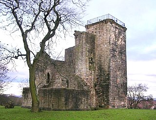
Crookston Castle is a ruined medieval castle in the Pollok area of Glasgow, Scotland. It is located some 5 miles (8 km) south-west of the city centre, on a hill overlooking the Levern Water, just before its confluence with the White Cart Water. Crookston Castle was built by the Stewarts of Darnley around 1400, and is set within earthworks constructed in the 12th century. Once the property of the earls and dukes of Lennox, the castle was extensively repaired following a siege in 1544, and it is the only surviving medieval castle in Glasgow.

Halfway, also known as Halfwayhouse, is a neighbourhood on the south-west side of the city of Glasgow, Scotland. Once a small village in its own right, sitting on the original Renfrewshire-Lanarkshire border, the area takes its name from the fact that it lies equidistant between Glasgow and Paisley at a distance of 3 miles from each.

Glasgow Pollok was a burgh constituency represented in the House of Commons of the Parliament of the United Kingdom from 1918 until 2005, when it was replaced by Glasgow South West. It elected one Member of Parliament (MP) using the first-past-the-post voting system.

<span class="mw-page-title-main">River Cart</span> River in Scotland

The River Cart is a tributary of the River Clyde, Scotland, which it joins from the west roughly midway between the towns of Erskine and Renfrew and opposite the town of Clydebank.

Hawkhead is an area near Paisley in Renfrewshire, Scotland.

Rosshall Academy is a secondary school in the Rosshall (Crookston) area of Glasgow, Scotland. The school was formed in August 1999 to merge Penilee Secondary School (Penilee) and Crookston Castle Secondary School (Pollok) and moved to a new building roughly equidistant between them on Crookston Road in 2002. It holds over 1,100 pupils.

<span class="mw-page-title-main">Levern Water</span> River in Scotland

The Levern Water, is a small river in East Renfrewshire and Glasgow, Scotland. It rises in the Long Loch, and flows generally north and east, past the towns of Neilston and Barrhead, for a total distance of 9 miles (14 km). It empties into the White Cart River.

<span class="mw-page-title-main">Roughmussel</span>

Roughmussel is a neighbourhood in the Scottish city of Glasgow. It is situated south of the River Clyde near to the city boundaries with East Renfrewshire to the south and Renfrewshire to the west.

<span class="mw-page-title-main">Renfrew</span> Town in Renfrewshire, Scotland

Renfrew is a town 6 miles (10 km) west of Glasgow in the west central Lowlands of Scotland. It is the historic county town of Renfrewshire. Called the "Cradle of the Royal Stewarts" for its early link with Scotland's former royal house, Renfrew gained royal burgh status in 1397.

<span class="mw-page-title-main">Cardonald (ward)</span> Human settlement in Scotland

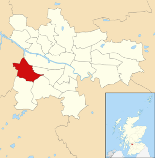
Cardonald is one of the 23 wards of Glasgow City Council. It was created in 2007 as Craigton and returned four council members using the single transferable vote system. The same name and boundaries were used in the 2012 elections. For the 2017 Glasgow City Council election, the name was changed although the territory and councillor numbers remained the same.

<span class="mw-page-title-main">Greater Pollok (ward)</span> Human settlement in Scotland

Greater Pollok is one of the 23 wards of Glasgow City Council. Since its creation in 2007 it has returned four council members, using the single transferable vote system.

<span class="mw-page-title-main">Leverndale Hospital</span> Hospital in Glasgow, Scotland

Leverndale Hospital is a mental health facility at Crookston, Glasgow, Scotland. It is managed by NHS Greater Glasgow and Clyde. The Towerview Unit, which has been taken out of use, is Category A listed.

<span class="mw-page-title-main">Rosshall</span> Area of Glasgow

Rosshall is an area in the south-west of Glasgow, Scotland, within the Cardonald ward of Glasgow City Council. It has a fairly isolated location, with the White Cart Water forming a border to the south and east, the Paisley Canal Line railway to the north, and open fields to the west that form a short green belt between Glasgow and the large town of Paisley – the nearest building 500 yards (460 m) to the west, Rosshall Mains Farm, falls under Paisley administration rather than Glasgow.

<span class="mw-page-title-main">Wards of Renfrewshire</span>

Renfrewshire is one of the 32 council areas of Scotland, formally established in 1996 to succeed the Renfrew district within the Strathclyde region, both of which were abolished; the headquarters are at Paisley.

References

  1. 1 2 3 4 5 6 7 8 9 10 11 12 13 14 15 16 17 18 19 Crookston Heritage Trail, Glasgow City Council
  2. 1 2 3 4 5 6 From historic tale to best seller | Living in Crookston, The Herald, 23 February 2000
  3. 1 2 Cruckston Castle (Pollok House, 1830), The Glasgow Story
  4. "Glasgow, 170 Brockburn Road, Crookston Castle". Canmore. Historic Environment Scotland.
  5. The Topographical, Statistical, and Historical Gazetteer of Scotland, Volume 1 (page 270), A. Fullarton, 1848
  6. Memoirs of the Maxwells of Pollok (page 6), William Fraser, 1863
  7. Follow the Arrow (page 115), Eddie Crooks, 2011, ISBN   9781447780274
  8. Glasgow, Pollok | Earthwork (Period Unassigned), Fort (Iron Age), Canmore
  9. The Mains of Cruickston (Pollok House, 1830), The Glasgow Story
  10. Crookston Castle, The Castles of Scotland
  11. Linzi Watson. Battle begins to reclaim castle for local community. Evening Times . 31 July 2013.
  12. 1 2 "View: John Thomson's Atlas of Scotland, 1832: Renfrew Shire". National Library of Scotland.
  13. Map of the Parish of Paisley in the Historical County of Renfrew, Gazetteer for Scotland
  14. Glasgow's growing pains, Evening Times, 26 November 2012
  15. No Mean City: 1914 to 1950s | Neighbourhoods | Boundary Extensions, The Glasgow Story
  16. About Us, Crookston Hotel
  17. 1 2 3 4 Which School Catchment?, Glasgow City Council
  18. Glasgow, Howford Bridge, Canmore
  19. Home, South Cardonald and Crookston Community Council
  20. 1 2 Asylums in Glasgow: The buildings where madness was managed, CommonSpace, 16 December 2016
  21. 1 2 3 4 5 Glasgow, Historic Hospitals
  22. Paisley, Hawkhead House, Canmore
  23. Paisley Mansions: Hawkhead, Paisley.org
  24. Leverndale Hospital (Glasgow Caledonian University, Research Collections, Heatherbank Museum of Social Work, 1975), The Glasgow Story
  25. Glasgow, Pollok, 510 Crookston Road, Leverndale Hospital, Canmore
  26. Newest ambulance station among busiest in country, Evening Times, 12 July 2011
  27. About us : News and Updates, NHS Greater Glasgow and Clyde
  28. 1 2 Renfrewshire Combination, Renfrewshire, Workhouses.org
  29. 1 2 Glasgow Takes Care of its Old Folk, (video footage, 1949), National Library of Scotland
  30. Crookston Home; Paisley; Renfrewshire; Scotland (1968), NCAP (Historic Environment Scotland)
  31. OS National Grid Maps, 1944-1967, Explore georeferenced maps (National Library of Scotland)
  32. Map of the Parish of Eastwood in the Historical Counties of Glasgow and Renfrew, Gazetteer for Scotland
  33. Pollok Housing (Glasgow City Archives, Department of Architectural and Civic Design, 1938), The Glasgow Story
  34. Kempsthorn Road (Glasgow City Archives, Department of Architectural and Civic Design, 1950), The Glasgow Story
  35. Lyoncross Road (Burrell Collection Photo Library, 1955 Survey), The Glasgow Story
  36. South Glasgow Rivers : Levern, White Cart and Brock Burn, ScotCities
  37. Subfonds GKC/SSP - Howford Special School, Pollok, Glasgow School of Art Archives and Collections
  38. School, Old Crookston Farm Site, Dictionary of Scottish Architects
  39. Rockers The View are wowed by music therapy for kids at Glasgow primary school, Daily Record, 11 November 2012
  40. Crookston Homes Elderly Care Unit. A Day In The Death Of An Institution, via YouTube
  41. Cottage haven for twilight years, Evening Times, 1 October 2012
  42. Pollok History | Crookston Homes, Me in G53
  43. GCC extend schools modernisation programme with Gowanbank Campus, Urban Realm, 23 February 2015
  44. Girl, 13, charged over fire at derelict school, BBC News, 2 August 2018
  45. Practice Info, Crookston Medical Centre
  46. Our History, Crookston Bowling Club
  47. About Us, Crookston Community Group
  48. Map Chooser, Scottish Index of Multiple Deprivation, 2020
  49. The Dragon of Haughhill, Owen Pilgrim, 2015
  50. Growth for Glasgow as business tourism benefits from record number of conferences, The National, 8 August 2017
  51. Meadowburn Care Home and Day Care Centre, Glasgow City Council
  52. RBS funds £4m Glasgow care home, Care Home Professional, 16 March 2018
  53. Home, Hurlet and Brockburn Community Council
  54. Family of Crookston murder victim call for "life to mean life", The Herald, 9 January 2015
  55. Crookston residents plagued by mould, collapsing ceilings and flooding, Evening Times, 10 May 2016
  56. Crookston murder bid: Taxi driver who mowed down young man in hit and run still on the loose one month on, Evening Times, 22 July 2017
  57. "Glasgow Network Map" (PDF). First Glasgow. 1 January 2018. Retrieved 18 October 2019.[ permanent dead link ]
  58. Partners from Chewin' the Fat serve up a nourishing new broth of off-the-wall fun | I say, there's two guys in my soup, The Herald, 18 June 2001
  59. 1 2 Lee, Mary (2005). Forever Francie : my life with Jack Milroy. Edinburgh, Scotland: Black & White Publishing. ISBN   9781845028329.