Germiston, Glasgow

Last updated

Germiston
Germiston - geograph.org.uk - 1262142.jpg
Royston Road, Germiston at Broomfield Road looking west (2009)
Glasgow UK location map.svg
Red pog.svg
Germiston
Location within Glasgow
OS grid reference NS617666
Council area
Lieutenancy area
  • Glasgow
Country Scotland
Sovereign state United Kingdom
Post town GLASGOW
Postcode district G21 2
Dialling code 0141
Police Scotland
Fire Scottish
Ambulance Scottish
UK Parliament
Scottish Parliament
List of places
UK
Scotland
Glasgow
55°52′22″N4°12′43″W / 55.87277°N 4.2119°W / 55.87277; -4.2119

Germiston is a neighbourhood in the city of Glasgow, Scotland, north of the River Clyde.

Contents

The area forms part of the suburb of Springburn for political purposes, but is more commonly referred to as part of the 'Royston Road corridor' flanked by the Cumbernauld Line railway and the M8 motorway (previously the Monkland Canal), its location midway between Blackhill to its east and Royston (Garngad) to its west earning it a position as the 'wee sister' of both of those better-known neighbourhoods.

History

It formerly centred around Germiston House, a mansion built in 1690 by Robert Dinwiddie, a tobacco lord in Virginia and father of Robert Dinwiddie, governor of Virginia, and Lawrence Dinwiddie, Lord Provost of Glasgow, both of whom were born there.

Lawrence Dinwiddie inherited the house and raised his 21 children there.

In 1864, the house was acquired by Rev Dr George Stewart Burns, minister of Glasgow Cathedral. The setting of the house was ruined by a railway line being placed beside it and it was used as housing for labourers from around 1890. [1]

During Glasgow's growth during the Industrial Revolution, Germiston was a vital part of the city's locomotive manufacturing industry as well as sitting upon a major railway junction. Germiston Works, one of such locomotive factories was sold onto the Cape Asbestos Company, who used it to manufacture fireproof insulation materials. The plant still exists to this day, under the ownership of Promat, and now uses the safer Calcium Silicate for such material.

A narrow gauge underground railway used to exist at Germiston, but most of the path it once took has now been filled in to develop the land for house building. Its tunnel, known locally as the "Blind Tunnel", now carries a single-track road from Darnick Street Tunnel to Royston Road and Forge Street, and is controlled by traffic lights with lighting for pedestrians. [2] It is often confused with an adjacent tunnel, which has now been blocked completely by metal fencing to prevent unauthorised access to the local Provan Gas Works. [3] The underground railway from Germiston transported coke to Provan Gas Works for the manufacture of natural gas.

15 Forge Place, Germiston (one of the area's three tower blocks) just before demolition, 2008 15 Forge Place, Germiston, Glasgow in 2008.jpg
15 Forge Place, Germiston (one of the area's three tower blocks) just before demolition, 2008

From 1967, three 18-storey tower blocks were built on Coll Place and Forge Place in Germiston. The Coll Street project provided 306 new dwellings. [4] [5] The blocks were demolished in 1992, [6]
2008, [7] and 2011. [8]

In the early 21st century, construction of private housing injected some new investment into what was a decaying area, with most residents surviving on low incomes following the collapse of local heavy industries and most of the housing stock dating from the 1930s; combined with new developments on the old railway yards on Royston Road, this has done much to breathe new life into the area.

Education

Barmulloch Primary School (with its core community about one-half mile or one kilometre to the north) is located in Germiston on Forge Street, with the school previously based at that location, St Gilbert's RC Primary, having closed at the same time as the original incoming school (Berryburn Road, Barmulloch) in 2009 as part of a Glasgow City Council closure and re-alignment programme amid declining populations in both areas (St Gilbert's pupils were reassigned to St Philomena's in the Provanmill area, and to St Roch's in Royston). [9] Barmulloch Primary is affiliated to Springburn Academy, but other local children who attend Royston Primary School would attend Smithycroft Secondary School in Riddrie, as do those from Wallacewell Primary which serves North Balornock and Robroyston further north of Barmulloch, although Riddrie is geographically closer to Germiston than Robroyston, North Balornock or Royston. [10] Local Catholic pupils have a different issue, with those who attend St Roch's Primary transferring to the secondary school of the same name, but those going to St Philomena's Primary expected to move to All Saints Secondary in Barmulloch. [10]

Transport

Germiston is served by bus routes 19 (Glasgow - Easterhouse) run by First Glasgow, 19A (Glasgow - Robroyston) run by JMB Travel [11] and First, and 329 (Glasgow - Stobhill Hospital via Roystonhill) run by PVT Transfer Ltd on behalf of Strathclyde Partnership for Transport. [12]

It was formerly served by the Glasgow tram route number 2 (Polmadie - Provanmill).It was replaced with the trolleybus service 102 in 1949, which ran until 1966. [13] [14]

Despite the extensive rail infrastructure that shapes the area, Germiston has no passenger railway station, the closest being Barnhill.

See also

Related Research Articles

<span class="mw-page-title-main">Lanarkshire</span> Historic county in Scotland

Lanarkshire, also called the County of Lanark, is a historic county, lieutenancy area and registration county in the Central Lowlands of Scotland. The county is no longer used for local government purposes, but gives its name to the two modern council areas of North Lanarkshire and South Lanarkshire.

<span class="mw-page-title-main">Robroyston</span> Human settlement in Scotland

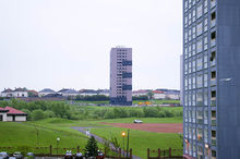
Robroyston is a suburb of Glasgow, Scotland, located around 3 miles (5 km) north-east of the city centre.

<span class="mw-page-title-main">Glasgow North East (UK Parliament constituency)</span> Parliamentary constituency in the United Kingdom, 2005 onwards

Glasgow North East is a burgh constituency of the House of Commons of the Parliament of the United Kingdom. It was first contested at the 2005 general election. The current Member of Parliament (MP) is Anne McLaughlin of the SNP. McLaughlin herself previously represented the seat from 2015-17, when she lost the seat to Labour, but regained the seat at the 2019 general election and has represented the constituency ever since.

Glasgow Springburn was a constituency of the House of Commons of the Parliament of the United Kingdom from 1918 until the 2005 general election, when it was largely replaced by the Glasgow North East constituency.

<span class="mw-page-title-main">Springburn</span> Inner-city district in Scotland

Springburn is an inner-city district in the north of the Scottish city of Glasgow, made up of generally working-class households.

<span class="mw-page-title-main">Balornock</span> Human settlement in Scotland

Balornock is a district in the city of Glasgow, Scotland. Situated outside the city centre, north of the River Clyde, it forms part of the larger area of Springburn.

<span class="mw-page-title-main">Colston, Glasgow</span> Human settlement in Scotland

Colston is a mostly residential area in the Scottish city of Glasgow; situated on the northern edge of the city, it is surrounded by the Glasgow areas of Milton to the west and Springburn to the east, and the town of Bishopbriggs to the north. The main road through Colston is the A803, which then becomes Kirkintilloch Road once past Colston to the north through Bishopbriggs.

<span class="mw-page-title-main">Cowlairs</span> Human settlement in Scotland

Cowlairs is an area in the Scottish city of Glasgow, part of the wider Springburn district of the city. It is situated north of the River Clyde, between central Springburn to the east and Possilpark to the west.

<span class="mw-page-title-main">Hogganfield</span> Human settlement in Scotland

Hogganfield is a district in the Scottish city of Glasgow, located to the north east of the city centre. Hogganfield is surrounded by the Glasgow districts of Blackhill, Craigend, Millerston, Provanmill, Riddrie, Robroyston, Ruchazie and Stepps. The M80, Stepps bypass, separates Hogganfield from Robroyston.

<span class="mw-page-title-main">Paul Martin (Scottish politician)</span> Scottish Labour politician (born 1967)

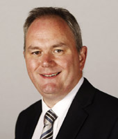
Paul Martin is a Scottish politician who served as Member of the Scottish Parliament (MSP) for the Glasgow Provan constituency from 2011 to 2016. A member of the Scottish Labour Party, he previously represented Glasgow Springburn from 1999 to 2011.

Blackhill is an area of north east Glasgow, Scotland. It is directly bordered by the M80 motorway to the west and the M8 motorway to the south. The neighbourhood falls within the North East ward under Glasgow City Council.

<span class="mw-page-title-main">Stobhill Hospital</span> Hospital in Scotland

Stobhill Hospital is located in Springburn in the north of Glasgow, Scotland. It serves the population of North Glasgow and part of East Dunbartonshire. It is managed by NHS Greater Glasgow and Clyde.

<span class="mw-page-title-main">All Saints Roman Catholic Secondary School</span> Comprehensive, secondary school in Glasgow, Scotland

All Saints Roman Catholic Secondary School is a comprehensive, co-educational, Roman Catholic state school situated in Barmulloch the north-east of Glasgow, Scotland. Established in 1972, the school was rebuilt into a newer, more modern version in 2002, with better facilities but fewer classrooms. The headteacher is Brian McDermott.

<span class="mw-page-title-main">Glasgow Corporation Tramways</span> Closed urban tramway system in Glasgow, Scotland

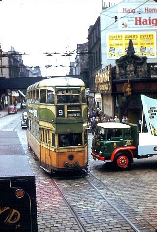
Glasgow Corporation Tramways were formerly one of the largest urban tramway systems in Europe. Over 1000 municipally-owned trams served the city of Glasgow, Scotland, with over 100 route miles by 1922. The system closed in 1962 and was the last city tramway in Great Britain.

<span class="mw-page-title-main">Trolleybuses in Glasgow</span> Public transport system in Glasgow, Scotland

The Glasgow trolleybus system operated in and immediately surrounding the city of Glasgow, Scotland, between 1949 and 1967, with the network reaching its largest extent in 1959. It was the only British system to open after World War II.

<span class="mw-page-title-main">Housing in Glasgow</span> Overview of housing in Glasgow, Scotland

Glasgow, the largest city in Scotland, has several distinct styles of residential buildings. Building styles reflect historical trends, such as rapid population growth in the 18th and 19th centuries, deindustrialization and growing poverty in the late 20th century, and civic rebound in the 21st century.

The Switchback was a railway line in the East End of Glasgow, Scotland, constructed by the Caledonian Railway (CR). Connecting the lines at Rutherglen on the south side of the city with Robroyston on the north side, this route also served a number of industrial sidings and rail yards.

<span class="mw-page-title-main">Springburn/Robroyston (ward)</span> Human settlement in Scotland

Springburn/Robroyston is one of the 23 wards of Glasgow City Council. Created as Springburn, in 2007 and in 2012 it returned three council members, using the single transferable vote system. For the 2017 Glasgow City Council election, the boundaries were changed, the ward increased in size and population, was renamed Springburn/Robroyston and returned four members.

<span class="mw-page-title-main">North East (Glasgow ward)</span> Ward in Glasgow

North East is one of the 23 wards of Glasgow City Council. On its creation in 2007 and in 2012 it returned four council members, using the single transferable vote system. For the 2017 Glasgow City Council election, the ward boundaries were redrawn with a smaller size and population, and it returned three members.

References

  1. "letter3". ripple4u.tripod.com. Retrieved 4 August 2021.
  2. Your pictures of Scotland: 19 - 26 July, BBC, 2 August 2019
  3. Glasgow tunnels, Urban Glasgow, 8 September 2009
  4. "Tower Block UK: Coll Street". University of Edinburgh . Retrieved 13 January 2019.
  5. "Buildings in Glasgow: Coll Street". Emporis. Archived from the original on 27 February 2019. Retrieved 27 February 2019.
  6. Historic Environment Scotland. "9 Coll Place demolition (1415149)". Canmore . Retrieved 17 February 2019.
  7. "15 Forge Place, Germiston, Glasgow". Safedem. Retrieved 17 February 2019.
  8. "Coll Place Demolition". Safedem. 13 May 2011. Retrieved 17 February 2019.
  9. School closure consultation ends, BBC News, 18 March 2009
  10. 1 2 Which School Catchment? (interactive map), Glasgow City Council
  11. "19A - Robroyston - Glasgow".
  12. 329 Glasgow Roystonhill Springburn Stobhill Hospital
  13. "Glasgow's Trolleybuses | Glasgow History". 5 June 2018.
  14. "GCT Trolleybus Route Map". Archived from the original on 23 March 2019.