
Nitshill is a district on the south side of Glasgow. It is bordered by South Nitshill to the south, Darnley to the east, Crookston and Roughmussel to the north-west, Hurlet to the west and Househillwood and Priesthill to the north, with the Pollok district and the Silverburn Centre beyond. An area of open ground to the south-west of Nitshill forms the boundary between Glasgow and the town of Barrhead in East Renfrewshire.

Pollok is a large housing estate on the south-western side of the city of Glasgow, Scotland. The estate was built either side of World War II to house families from the overcrowded inner city. Housing 30,000 at its peak, its population has since declined due to the replacement of substandard housing with lower-density accommodation. As of 2021, the population was recorded at 81,951 people.
Pollokshaws is an area on the South side of the city of Glasgow, Scotland. It is bordered by the residential neighbourhoods of Auldhouse to the east, Eastwood and Hillpark to the south and Shawlands to the north, with the Glasgow South Western Line railway and the open lands of Pollok Country Park to the west. The White Cart Water flows through the area.

Knightswood is a suburban district in Glasgow, containing three areas: Knightswood North or High Knightswood, Knightswood South or Low Knightswood, and Knightswood Park. It has a golf course and park, and good transport links with the rest of the city. Garscadden and Scotstounhill railway stations serve Low Knightswood while Westerton station serves High Knightswood. Knightswood is directly adjoined by the Anniesland, Blairdardie, Drumchapel, Garscadden, Jordanhill, Netherton, Scotstoun, Scotstounhill and Yoker areas of Glasgow, and by Bearsden in the north.

Newton Mearns is a suburban town and the largest settlement in East Renfrewshire, Scotland. It lies 7 miles (11 km) southwest of Glasgow City Centre on the main road to Ayrshire, 410 feet (125 m) above sea level. It has a population of approximately 26,993, stretching from Whitecraigs and Kirkhill in the northeast to Maidenhill in the southeast, to Westacres and Greenlaw in the west and Capelrig/Patterton in the northwest.

Shawlands is a Southside suburb of Glasgow, Scotland, located two miles south of the River Clyde. The area, considered the "Heart of the Southside", is known for its independent restaurants and cafés, art scene, public parks, period terraces, and red and blond sandstone tenements. Shawlands was named one of the best places to live in Scotland in 2022 and 2023 by The Sunday Times, and one of the world's coolest neighbourhoods by Time Out Magazine with judges describing it as "the city's best area to live and socialise”. It is located between Pollok Country Park, the home of the Burrell Collection and Pollok House, and the acclaimed Victorian park Queen's Park.

Southpark Village is a housing estate in the Darnley area of the Scottish city of Glasgow. The northwestern area was built during the mid to late 1980s, but the southeastern part was built in the late 2010s. It is located on the south-western edge of the city, close to the towns of Barrhead and Newton Mearns in East Renfrewshire. Nearby areas within Glasgow itself are the rest of Darnley to the north, Deaconsbank to the east, and Parkhouse to the northwest, although Southpark is physically separated from all but the rest of Darnley by the Dams to Darnley Country Park and M77 motorway.

Pollok Country Park is a 146-hectare (361-acre) country park located between Shawlands, Crossmyloof, and Pollok in Glasgow, Scotland. In 2007, Pollok Country Park was named Britain's Best Park, and in 2008 it was named the Best Park in Europe, beating competition from parks in Italy, France, Germany, Poland and Sweden. Despite this, by 2019 it was considered that the park was 'underused' with plans drawn up to encourage more visitors.
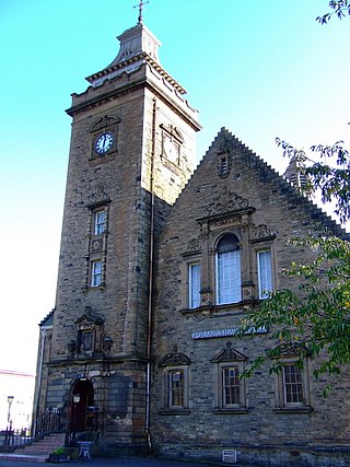
Crookston is a residential suburb on the southwestern edge of the city of Glasgow, Scotland.

Robroyston is a suburb of Glasgow, Scotland, located around 3 miles (5 km) north-east of the city centre.
Priesthill is a neighbourhood in the south of the River Clyde in the Scottish city of Glasgow. It falls under the Greater Pollok ward of the city council area. The Darnley neighbourhood is located to the south, on the opposite side of the Glasgow South Western Line railway, while Nitshill lies to the west and Househillwood and the Silverburn Centre shopping complex to the north. The M77 motorway runs to the east of Priesthill with open farmland beyond.

Newarthill is a village in North Lanarkshire, Scotland, situated roughly three miles north-east of the town of Motherwell. It has a population of around 6,200. Most local amenities are shared with the adjacent villages of Carfin, Holytown and New Stevenston which have a combined population of around 20,000 across the four localities.

Silverburn is an out-of-town shopping centre located on Barrhead Road in Pollok, Glasgow, Scotland. The development replaces the 75-acre (30-hectare) Pollok centre with a brand new 1,500,000-square-foot (140,000-square-metre) shopping centre, anchored by Tesco, Next, Marks & Spencer and previously Debenhams before it closed in 2021.

Glasgow Fort is a large out-of-town shopping and leisure park located in Glasgow, Scotland, just off Junction 10 of the M8 motorway which runs to the south, surrounded by the residential areas of Provanhall, Garthamlock and Easterhouse. It was opened in 2004 built on land which had been part of Auchinlea Park which still exists to its immediate east.

Deaconsbank is a neighbourhood in the Scottish city of Glasgow. It is situated south of the River Clyde. The main feature of the area, which falls into the Greater Pollok ward of Glasgow City Council and directly borders the East Renfrewshire council region, is an estate of around 639 private houses built in the late 1970s by Barratt Developments, prior to which the area was open farmland. Deaconsbank is bordered by the M77 motorway to the west and by Rouken Glen Park and golf course to the east. The northern parts of the suburban town of Newton Mearns are a short distance to the south, as is Patterton railway station.
In the United Kingdom, an out-of-town shopping centre is an enclosed shopping centre located outside of a town centre. The impact of out-of-town shopping centres in the United Kingdom is studied in the context of urban planning, town centre redevelopment, the retail industry and even public health and gender divides. Due to its significance for these issues, it has been included in the school exam curriculum in geography. There are only about sixteen out-of-town enclosed shopping centres in the United Kingdom. Under current policy, no more will be built. All other British shopping centres are in town and city centres.

Jenny Lind is a small neighbourhood in the Scottish city of Glasgow. It is situated south of the River Clyde, contiguous with the larger Deaconsbank neighbourhood and across a dual carriageway from the Arden and Thornliebank Industrial Estate. It was extended slightly in the 21st century by the addition of Jenny Lind Court. Jenny Lind falls under the Glasgow City Council Greater Pollok ward and has a short border with Deaconsbank Golf Club and Rouken Glen Park in the East Renfrewshire council region.

Old Drumchapel is a neighbourhood of Glasgow, Scotland. It is located around Drumchapel railway station and formed part of the Cowdenhill and Garscadden Estates. It is situated to the south of the larger and newer Drumchapel housing estate, and to the north of the arterial Great Western Road running from Glasgow to Clydebank. The Blairdardie neighbourhood lies immediately to the east, while a retail park separates Old Drumchapel from the Linnvale and Drumry areas of Clydebank to the west.

Parkhouse is a residential neighbourhood of Glasgow, Scotland close to the border with East Renfrewshire. It is located on the south-western edge of the city, close to the towns of Barrhead and Newton Mearns in East Renfrewshire. Within the G53 postcode area and the Greater Pollok ward of the Glasgow City Council administration, the eastern cluster of private housing was constructed in the 1980s and the western part in the 2010s, prior to which it was open farmland annexed to Glasgow in 1938.
Househillwood is a residential neighbourhood of Glasgow, Scotland, situated in the south-west of the city.
