
Maryhill is an area of the City of Glasgow in Scotland. Maryhill is a former burgh. Maryhill stretches over 7 miles (11 km) along Maryhill Road. The Maryhill district has several sub-districts, such as Acre, Botany, Dawsholm Park, Firhill, Gairbraid, Gilshochill, Maryhill Park, North Kelvinside, Queen's Cross, St George's Cross, Cadder, Summerston, Woodside and Wyndford.

Pollok is a large housing estate on the south-western side of the city of Glasgow, Scotland. The estate was built either side of World War II to house families from the overcrowded inner city. Housing 30,000 at its peak, its population has since declined due to the replacement of substandard housing with lower-density accommodation.

Castlemilk is a district of Glasgow, Scotland. It lies to the far south of the city centre, adjacent to the Croftfoot and Simshill residential areas within the city to the north-west, the town of Rutherglen - neighbourhoods of Spittal to the north-east and Fernhill to the east, Linn Park and its golf course to the west, and the separate village of Carmunnock further south across countryside.

Kelvindale is a district in the West End of the city of Glasgow, Scotland. Kelvindale shares the G12 postcode with the neighbouring residential districts of Kelvinside, Hillhead, Hyndland, Dowanhill, as well as Gartnavel General Hospital, Glasgow Clyde College (Anniesland) and the University of Glasgow, and is also close to the Anniesland and Wyndford areas of the city. The area is characterised by traditional interwar housing, formed of tenements and semi-detached houses.
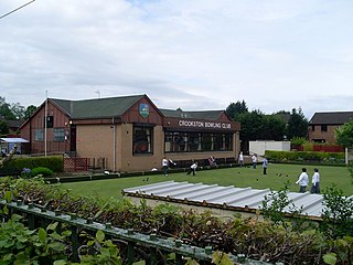
Crookston is a residential suburb on the southwestern edge of the city of Glasgow, Scotland.

Toryglen is a district in southern Glasgow, Scotland, falling within the Langside ward under Glasgow City Council. It is approximately two miles south of the city centre, bounded to the west by Mount Florida, the north-west by Polmadie, to the north-east by the West Coast Main Line railway and the M74 motorway the south by King's Park, and immediately to the east by the town of Rutherglen.

Springburn is an inner-city district in the north of the Scottish city of Glasgow, made up of generally working-class households.

Cowlairs is an area in the Scottish city of Glasgow, part of the wider Springburn district of the city. It is situated north of the River Clyde, between central Springburn to the east and Possilpark to the west.

Easterhouse is a suburb of Glasgow, Scotland, located on the periphery of the city approximately 6 miles (10 km) east of its centre, partially built on land gained from the county of Lanarkshire as part of a boundary expansion of Glasgow prior to the Second World War. The area is on high ground north of the River Clyde and south of the River Kelvin and Campsie Fells.

Milton is a district in the Scottish city of Glasgow, situated north of the River Clyde. The housing scheme is about 2.5 miles north of Glasgow City Centre and forms part of the northern edge of the city's urban area.

Queenslie is a district in the Scottish city of Glasgow.

Ruchill is a district in the city of Glasgow. It lies within the Canal Ward of North Glasgow in the Ruchill Community Council area between the Maryhill and Possilpark areas of the city. It has traditionally been characterised by a high degree of deprivation and social problems. However, from the late 1990s much of the poorer-quality housing stock has been cleared to be replaced by newly built housing association and owner-occupied homes, improving much of the area's character.

Sighthill is a neighbourhood in the Scottish city of Glasgow. It is situated north of the River Clyde and is part of the wider Springburn district in the north of the city. It is bordered to the north by Cowlairs, to the east by the Springburn Bypass road and the Royston neighbourhood, to the west by the Glasgow to Edinburgh via Falkirk Line and to the south by the Townhead interchange of the M8 Motorway.

Oatlands is an area in the city of Glasgow, Scotland. It is situated south of the River Clyde, falls within the Southside Central ward under Glasgow City Council, and is part of the Gorbals historic area. Its boundaries are Hutchesontown and the Southern Necropolis cemetery to the west, Polmadie to the south, Shawfield to the east, and Glasgow Green public park to the north.
Priesthill is a neighbourhood in the south of the River Clyde in the Scottish city of Glasgow. It falls under the Greater Pollok ward of the city council area. The Darnley neighbourhood is located to the south, on the opposite side of the Glasgow South Western Line railway, while Nitshill lies to the west and Househillwood and the Silverburn Centre shopping complex to the north. The M77 motorway runs to the east of Priesthill with open farmland beyond.
Blackhill is an area of north east Glasgow, Scotland. It is directly bordered by the M80 motorway to the west and the M8 motorway to the south. The neighbourhood falls within the North East ward under Glasgow City Council.

Cadder is a neighbourhood in the north of Glasgow, Scotland. Within the Canal ward under Glasgow City Council, historically more closely associated with the Lambhill and Maryhill districts, it is located 5 kilometres (3 mi) north of Glasgow city centre, sited on the route of the Forth and Clyde Canal. Occupying a footprint which is around 800 metres (870 yd) east to west but only 200 metres (220 yd) north to south on a fairly steep incline, the neighbourhood was built in the early 1950s and borders Glasgow Western Necropolis & Crematorium, Lambhill Cemetery and St. Kentigern's RC Cemetery, as well as Possil Marsh at its eastern side.
Parkhouse is a neighbourhood of Glasgow, Scotland. Within the G22 postcode area and the Canal ward of the Glasgow City Council administration, it is mainly residential in character having been constructed as a development primarily consisting of cottage flats in the early 1930s, prior to which it was open farmland.

Easthall is a residential neighbourhood in the East End of the Scottish city of Glasgow. Since 2007 it has been part of the Baillieston administrative ward within the Glasgow City Council area.
Canal is one of the 23 wards of Glasgow City Council. Since its creation in 2007 it has returned four council members, using the single transferable vote system. For the 2017 Glasgow City Council election, the boundaries were changed and the ward decreased in population, but continued to return four councillors.
