Oatlands, Glasgow

Last updated

Oatlands
Haughview Terrace, Oatlands, Glasgow - geograph.org.uk - 543950.jpg
New apartments on Haughview Terrace
Glasgow UK location map.svg
Red pog.svg
Oatlands
Location within Glasgow
Population1,827 (2018) [1]
Council area
Lieutenancy area
  • Glasgow
Country Scotland
Sovereign state United Kingdom
Post town GLASGOW
Postcode district G5
Dialling code 0141
Police Scotland
Fire Scottish
Ambulance Scottish
UK Parliament
Scottish Parliament
List of places
UK
Scotland
Glasgow
Coordinates: 55°50′23″N4°14′03″W / 55.83972°N 4.23417°W / 55.83972; -4.23417

Oatlands is an area in the city of Glasgow, Scotland. It is situated south of the River Clyde, falls within the Southside Central ward under Glasgow City Council, and is part of the Gorbals historic area. Its boundaries are Hutchesontown and the Southern Necropolis cemetery to the west, Polmadie to the south (across the M74 motorway and West Coast Main Line railway), Shawfield (part of the town of Rutherglen) to the east, and Glasgow Green public park to the north (across the River Clyde).

Contents

Oatlands is connected to the Green via Polmadie Bridge which was dismantled in 2015 due to structural safety concerns and replaced in 2018.

History

Until the 1990s, the area was characterised by four-storey red sandstone tenements built at the end of the 19th century and the start of the 20th, [2] [3] and three-storey Rehousing (low build quality) grey reconstituted stone tenements from the 1930s. [3] [4] [5] [6] [7] A continuous line of tenements faced Richmond Park – a typical large urban park with boating pond, opened in 1899 and named after the Lord Provost of the time, Sir David Richmond whose tube works were located nearby [8] – across busy Rutherglen Road, one of Glasgow's main arterial routes. [9] [10] [11]

Notable features included a small cinema [12] and a place of worship designed by John Honeyman, known as the Buchanan Memorial Church and later St Bonaventure's RC Church (after being used as a factory); [13] [14] its associated schools were sited just off the main road at the western end of the neighbourhood [15] (the secondary school was extended and renamed as John Bosco Secondary School in the 1970s) with the nondenominational Woseley Street Primary School [16] and the local 'steamie' (washhouse) [17] also nearby. By the mid-1990s, almost all of these amenities had either been knocked down or were scheduled for demolition along with the housing, [3] the main exception being St Margaret's Church which was earmarked as the site of a new community centre, but its conversion was delayed by various factors including the poor condition of the building. [18] [19] [20]

Richmond Park School, a specially-designed facility for children with physical disabilities, was built on the site of Woseley Street School, but its roll merged with Kelbourne School in the west end of the city in 2009, in spite of protests by parents and staff. [21] [22] [23] The intention was to move pupils from another ASN school, Hampden School in Toryglen, into the Richmond Park site, and this process was accelerated when the existing Hampden buildings were subject to an arson attack in 2010. [24] The Oatlands facility was subsequently renamed Hampden School [25] [26] and is the only educational provision in the area.

'Rehousing' tenements in Granton Street awaiting demolition (2008) Old Oatlands - geograph.org.uk - 714396.jpg
'Rehousing' tenements in Granton Street awaiting demolition (2008)

After a long process of demolitions –beginning with the red sandstone tenements which had been redeveloped just a few years earlier, leading to more problems being created than solved [3] – in April 2005 work started on a comprehensive redevelopment scheme to create a new neighbourhood consisting of around 1,510 houses (1,217 or 81% new private and 293 or 19% for social rental, 213 of which are new). [27] The award-winning project was promoted by Glasgow City Council, the lead developer being Bett Homes (later Avant Homes) [28] with involvement from the Link and Glasgow Housing Associations, the local housing stock of the latter now being owned and managed by the New Gorbals Housing Association. By September 2007, part of the traffic by-pass (including a new Boulevard), 44 private houses and 172 social-rented dwellings had been constructed.

Progress was severely impacted by the Great Recession from 2007 onwards, [29] however the walkway by the River Clyde, linking to Hutchesontown, was reopened in 2011. Also at that time, the M74 extension motorway project was completed, with a junction serving Oatlands. [30] Part of the land clearance in the area (including the removal of the derelict Rosebery Park football ground) had been for the construction of the motorway and the reconfiguration of its major road to meet this new junction and connect to the Glasgow East End Regeneration Route, [31] [32] [33] but had also encountered safety problems and attracted protests due to the presence in the ground of carcinogenic Chromium VI which had been dumped by a large chemicals firm that had operated nearby. [34] [35] That contamination also affected the burn running through Richmond Park into the River Clyde, causing the water to turn unnatural shades of green or yellow at times. [36] [37] [38]

Over 500 houses had been completed by 2014, with detailed planning permission given that year for another 378 private houses. [27] [39] The new tenements around Oatlands Square (a name previously in use in the district's 19th century street plan, although not in the same location) involved the installation of public artwork. [40] A steel sculpture on a prominent junction, named 'Oatlands Girl' and featuring references to the district's past, was unveiled by Nicola Sturgeon in 2016. [41] Two allotment sites were laid out, and the Oatlands Development Trust created a new play area [27] as the first phase of the £2 million extension and upgrading of Richmond Park. [42] [43] [44] [lower-alpha 1]

The Boulevard looking north The Boulevard, Oatlands, Glasgow - geograph.org.uk - 543939.jpg
The Boulevard looking north

The diversion of Rutherglen Road to the southern edge of the site was designed to allow integration of nearly all the housing with Richmond Park. A family pub/restaurant opened in 2018, [46] while future plans include a community centre, shop units, and school improvements. The project is almost entirely funded by Avant Homes in lieu of payment to Glasgow City Council for the land. [28] [47]

The regeneration project was not without controversy. For many years, redevelopment was prevented because of the risk of fire or explosion from propane stored nearby; 756 flats in red sandstone tenements were demolished after the failure of a £7 million refurbishment scheme. Attempts to regenerate the area were initially stymied by proposals for a business park and resistance from Housing Department officials. Later, although the area's character reflects the outcome of an intensive process of community engagement, the area's design is occasionally the subject of criticism by modernist architects, but signs indicate that the new Oatlands will, if completed in accordance with current plans, become one of Glasgow's more popular residential neighbourhoods. [27]

Notes

  1. There is also another 'Richmond Park' a few miles to the east, bordering the Rutherglen neighbourhood of Eastfield; this name was familiar to Glasgow bus users as the terminus for the First Glasgow No 12 service and was the site of a large laundry throughout the 20th century [45] (to add to the confusion, several other bus services towards Rutherglen run via Oatlands, including the 267 which passes both Richmond Parks).

Notable people

Related Research Articles

Benburb F.C. Association football club in Glasgow City, Scotland, UK

Benburb Football Club is a Scottish football club, based in Govan, Glasgow. Formed in 1885, the club is a member of the Scottish Junior Football Association and currently competes in the West of Scotland Football League. Benburb's colours are blue and white.

Gorbals Area in the city of Glasgow, Scotland

The Gorbals is an area in the city of Glasgow, Scotland, on the south bank of the River Clyde. By the late 19th century, it had become densely populated; rural migrants and immigrants were attracted by the new industries and employment opportunities of Glasgow. At its peak, during the 1930s, the wider Gorbals district had swollen in population to an estimated 90,000 residents. Along with its relatively small size, this gave the area a very high population density of around 40,000/km². Redevelopment after WWII has taken many turns, and the area's population is substantially smaller today.

Rutherglen Human settlement in Scotland

Rutherglen is a town in South Lanarkshire, Scotland, located immediately south-east of the city of Glasgow – 3 miles (4.8 km) from its centre – and directly south of the River Clyde. Having existed as a Lanarkshire burgh in its own right for more than 800 years, in 1975 Rutherglen lost its own local council and administratively became a component of the City of Glasgow District Council within the Strathclyde region. In 1996 the towns were reallocated to the South Lanarkshire council area.

Castlemilk Human settlement in Scotland

Castlemilk is a district of Glasgow, Scotland. It lies to the far south of the city centre, adjacent to the Croftfoot and Simshill residential areas within the city to the north-west, the town of Rutherglen - neighbourhoods of Spittal to the north-east and Fernhill to the east, Linn Park and its golf course to the west, and the separate village of Carmunnock further south across countryside.

Toryglen Human settlement in Scotland

Toryglen is a district in southern Glasgow, Scotland, falling within the Langside ward under Glasgow City Council. It is approximately two miles south of the city centre, bounded to the west by Mount Florida, the north-west by Polmadie, to the north-east by the West Coast Main Line railway and the M74 motorway the south by King's Park, and immediately to the east by the town of Rutherglen.

Croftfoot Human settlement in Scotland

Croftfoot is a residential area on the southeastern side of the Scottish city of Glasgow. It is bordered by Castlemilk to the south and King's Park to the west within Glasgow, and by the Rutherglen areas of Spittal to the east and Bankhead to the north. Historically within the civil parish of Cathcart in Renfrewshire, it is within the Linn ward of Glasgow City Council.

Craigend, Glasgow Neighbourhood in Scotland

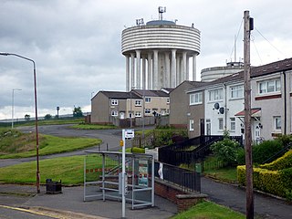
Craigend is a neighbourhood in the Scottish city of Glasgow. It is situated north of the River Clyde, immediately west of Garthamlock, east of Hogganfield Park and Ruchazie and separated from Cranhill and Queenslie to the south by the M8 motorway. An area of open ground is to the north. The local landmarks are two water towers, which are illuminated at night.

Dalmarnock Human settlement in Scotland

Dalmarnock is a district in the Scottish city of Glasgow. It is situated east of the city centre, directly north of the River Clyde opposite the town of Rutherglen. It is also bounded by the Glasgow neighbourhoods of Parkhead to the north-east and Bridgeton to the north-west.

Queenslie Human settlement in Scotland

Queenslie is a district in the Scottish city of Glasgow.

Ruchazie Human settlement in Scotland

Ruchazie is a neighbourhood in the Scottish city of Glasgow. It is situated to the north-east of the city, bordered by Craigend and Garthamlock to the east and the open ground of Hogganfield Park and Lethamhill Golf Course to the north. Ruchazie is separated from Cranhill to the south and Riddrie to the west by the M8 motorway, previously the route of the Monkland Canal.

Sighthill, Glasgow Human settlement in Scotland

Sighthill is a neighbourhood in the Scottish city of Glasgow. It is situated north of the River Clyde and is part of the wider Springburn district in the north of the city. It is bordered to the north by Cowlairs, to the east by the Springburn Bypass road and the Royston neighbourhood, to the west by the Glasgow to Edinburgh via Falkirk Line and to the south by the Townhead interchange of the M8 Motorway.

Eastfield, South Lanarkshire Human settlement in Scotland

Eastfield is a mainly residential district in Scotland, sandwiched between the South Lanarkshire industrial towns of Rutherglen and Cambuslang in the south-east of the Greater Glasgow urban area. It is situated south of the River Clyde, adjoining the Stonelaw and Burnside neighbourhoods of Rutherglen, and Silverbank in Cambuslang.

Fernhill, South Lanarkshire Human settlement in Scotland

Fernhill is a residential neighbourhood in the Scottish town of Rutherglen in South Lanarkshire; it is situated south of the River Clyde and borders the Rutherglen neighbourhoods of High Burnside to the north and Cathkin to the east, the Glasgow district of Castlemilk to the west, and the open lands of Fernbrae Meadows to the south. Its location on a steep incline which is part of the Cathkin Braes range of hills offers panoramic views over the south and eastern parts of Greater Glasgow.

Polmadie Human settlement in Scotland

Polmadie is a primarily industrial area of Glasgow in Scotland. Situated south of the River Clyde, Polmadie is close to residential neighbourhoods including Govanhill and Toryglen (south-east), with Oatlands and another large industrial zone at Shawfield to the north on the opposite side of major railway lines and the M74 motorway, Junction 1A of which serves the area.

Hutchesontown Human settlement in Scotland

Hutchesontown is an inner-city area in Glasgow, Scotland. Mostly residential, it is situated directly south of the River Clyde and forms part of the wider historic Gorbals district, which is covered by the Southside Central ward under Glasgow City Council.

Burnside, South Lanarkshire Human settlement in Scotland

Burnside is a mostly residential area in the town of Rutherglen in South Lanarkshire, Scotland. Including the neighbourhoods of High Burnside and High Crosshill, respectively south and north-west of its main street, it borders Overtoun Park in Rutherglen plus several other residential areas of the town, as well as western parts of neighbouring Cambuslang.

Shawfield Football Club was a Scottish football team that competed in the Junior set-up and won the Scottish Junior Cup in 1946–47. There are also a number of references to them being called Shawfield Juniors.

Shawfield Human settlement in Scotland

Shawfield is an industrial/commercial area of the Royal Burgh of Rutherglen in South Lanarkshire, Scotland, located to the north of the town centre. It is bordered to the east by the River Clyde, to the north by the Glasgow neighbourhood of Oatlands and the adjacent Richmond Park, to the south-west by Glasgow's Polmadie and Toryglen districts, and to the south-east by Rutherglen's historic Main Street and its Burnhill neighbourhood, although it is separated from these southerly areas by the West Coast Main Line railway tracks and the M74 motorway. A road bridge connects Shawfield to the Dalmarnock, Bridgeton and Glasgow Green areas.

Polmadie Bridge

The Polmadie Bridge is a footbridge that crosses the River Clyde, Glasgow, Scotland between Glasgow Green to its north, and Oatlands to its south.

Kelvinhaugh, Glasgow Human settlement in Scotland

Kelvinhaugh is a neighbourhood in the city of Glasgow, Scotland. It is situated directly north of the River Clyde in the West End of the city.

References

  1. 2011 Data Zone: Toryglen and Oatlands - 07, Scottish Government Statistics
  2. "Neighbourhoods: The Gorbals". The Glasgow Story. Retrieved 29 September 2018.
  3. 1 2 3 4 A few home truths, The Herald, 9 September 1997
  4. "Glasgow Corporation Housing Department (later Architectural & Planning Department, Glasgow Corporation)". Dictionary of Scottish Architects. Retrieved 28 September 2018.
  5. Glasgow, general view, showing Alley and MacLellan Ltd. Sentinel Works, Jessie Street and Polmadie Road. Oblique aerial photograph taken facing north, Canmore (1949, showing Oatlands skyline-1)
  6. Glasgow, general view, showing Alley and MacLellan Ltd. Sentinel Works, Jessie Street and Glasgow Green. Oblique aerial photograph taken facing north, Canmore (1949, showing Oatlands skyline-2)
  7. Glasgow, Polmadie, General, Canmore (aerial images, 1991)
  8. "Sir David Richmond". The Glasgow Story. Retrieved 28 September 2018.
  9. Richmond Park, Oatlands, Glasgow. Oblique aerial photograph taken facing north-west, Canmore (labelled 1936, but Polmadie Bridge is present)
  10. Vertical aerial view centred on Polmadie Motive Power Depot (new), Canmore (1980)
  11. Richmond Park, Glasgow City Council
  12. Ritz Cinema, Oatlands, The Glasgow Story
  13. Glasgow, 392 Caledonia Road, Buchanan Memorial Free Church, Canmore
  14. Gorbals, Glasgow: Hutchesowntown, Scotcities (Gerald Blaikie)
  15. Glasgow in the 1960s, 70s & 80s - Around The City Vol 1, Urban Glasgow, 26 October 2009
  16. Wolseley St, Virtual Mitchell (Mitchell Library)
  17. Memories: the Oatlands Wash House in 1950, Evening Times, 5 May 2015
  18. St Margaret's Polmadie Church, Halls and Manse (Former), 110, Polmadie Road, Polmadie, Buildings at Risk (Historic Environment Scotland), 17 June 2014
  19. St Margaret's, Oatlands, Simpson & Brown Architects
  20. Oatlands residents to get temporary community centre after five year battle, Evening Times, 7 November 2016
  21. Parents oppose merger of special schools, The Herald, 11 September 2009
  22. My old school has put me at top of world, Evening Times, 22 September 2009
  23. School's history lesson plea, Evening Times, 10 October 2014
  24. Glasgow school fire was started deliberately, STV News, 30 April 2010
  25. Rising from the ashes; Terms of endearment, Evening Times, 20 December 2011
  26. Welcome to our school, Hampden School
  27. 1 2 3 4 Smith, Ronald P A, 'The Gorbals & Oatlands - A New History, Volume 4: Oatlands and General Conclusions', Stenlake Publishing, 2014
  28. 1 2 "Oatlands Regeneration". Glasgow City Council . Retrieved 29 September 2018.
  29. 1 2 "Oatlands £1 property deal has turned into 'nightmare'". Evening Times. 15 January 2013. Retrieved 29 September 2018.
  30. "M74 will benefit Scottish Economy". Transport Scotland. 28 June 2011. Archived from the original on 6 June 2013. Retrieved 29 September 2018.
  31. Oblique aerial view centred on the motive traction depot, taken from the SE, Canmore (2010, showing cleared land and road construction)
  32. Oblique aerial view centred on the Motive Power depot, taken from the SW Canmore (2010, showing cleared land and road construction)
  33. "New £25m Clyde Gateway road opens in Glasgow". BBC News. BBC. 26 April 2012. Retrieved 24 June 2012.
  34. "Euro ruling doubt over M74 plans". BBC News . 17 September 2004. Retrieved 29 September 2018.
  35. £2million plan to clean up Shawfield, Daily Record, 8 February 2019
  36. "Harmful chemicals in green Glasgow burn to be flushed". BBC News. 19 February 2019. Retrieved 25 August 2019.
  37. "Polmadie Burn: 'Erin Brockovich' River Clyde toxic disaster 'poses no risk to public'". Evening Times. 8 March 2019. Retrieved 25 August 2019.
  38. Suter, Ruth (26 April 2021). "SEPA called to investigate 'toxic' Glasgow burn". The Glasgow Times. Retrieved 27 April 2021.
  39. Oatlands regeneration moves ahead with planning approval, Urban Realm, 17 June 2014
  40. "New homes in Glasgow's Oatlands open the Gate to a thriving new community". Daily Record. 2 February 2018. Retrieved 29 September 2018.
  41. First Minister unveils new artwork in Glasgow's south side, Glasgow Live, 9 September 2016
  42. "Richmond Park Design Brief to Avant Homes". Glasgow City Council. 31 August 2016. Retrieved 29 September 2018.
  43. "Richmond Park". Clyde Waterfront. Retrieved 7 February 2018.
  44. Final phase of Oatlands regeneration proceeds, Urban Realm, 27 February 2017
  45. "Richmond Park Laundry". Canmore . Retrieved 7 February 2018.
  46. "Our Pub". Jenny Burn (Marston's). Retrieved 29 September 2018.
  47. What’s on offer in Oatlands, Avant Homes