Trinity High School, Rutherglen

Last updated

Trinity High School
Trinity High School Name and Logo.png
Trinity High School Rutherglen.jpg
Main building of school
Address
Trinity High School, Rutherglen


Scotland
Information
Type Roman Catholic
Motto"Home, school, church, stronger together"
Established1971
Authority South Lanarkshire
HeadmasterAllison Craig
Scottish Highers1st Years 6th Years
GenderMixed
Enrollment1,060
Colour(s)    
Purple, red, black, white
Website Trinity High School

Trinity High School is a Roman Catholic secondary school located in Eastfield, Rutherglen, Scotland near the city of Glasgow. It was established in 1971. The current head teacher is Allison Craig [1] who took office in 2021 with incumbent Peter Bollen [2] leaving his post.

Contents

Overview

Trinity High School was established in 1971 to provide a combined Catholic secondary education provision for Cambuslang and Rutherglen under the new comprehensive system, until that time based separately in limited accommodation at St Bride's and St Columbkille's schools respectively, but with many pupils from the towns having to attend schools either in Glasgow, further into Lanarkshire at Hamilton or Motherwell, or in East Kilbride. Initially Trinity used buildings in Cambuslang previously used by Gateside School, [3] which had been supplanted as the local non-denominational facility with the opening of Cathkin High School on a different site on the edge of town. In 1977 the Trinity campus at Eastfield was opened, [4] although the Gateside buildings continued to be used by the school for a few years [3] (it was later used by South Lanarkshire College, and eventually demolished in 2008). [5]

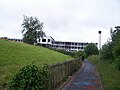
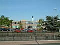
In 2007 the original Trinity was demolished; a new school was completed in the same Glenside Drive location. Pupils returned in August 2009. [4] A council-run sports centre and swimming pool (known as South Lanarkshire Lifestyle Eastfield) [6] constructed a few years earlier shares the site, with the facilities used by the Trinity pupils during the school day and available for community use at other times. [7]

The school uses a traditional house system. The pupils are organised into one of three guidance houses, formerly having been four. The three houses are Iona, Dunkeld and Melrose . Jedburgh was previously a house but was removed during re-organisation of the school faculty.

The school hosts many afterschool clubs and has competed in national competitions. Around mid-October an awards ceremony is held to honour pupils who have achieved academically and through sports activities. Although a Catholic school, it accepts students from other religious denominations.

Trinity's affiliated primary schools include St Anthony's in Springhall, St Bride's in Cambuslang, St Cadoc's in Halfway, St Charles' in Newton, St Columbkille's in Rutherglen, St Joachim's in Carmyle, and St Mark's in Blairbeth. [8]

History

New buildings, move to Hamilton

On 5 November 2007 the former school building in Glenside Drive, being demolished as part of the "Schools Modernisation Programme", [9] [10] [11] was set ablaze. Before it was set on fire, it was due to be destroyed by contractors InspirdED onto whom the council had passed responsibility. [10] [12]

The fire broke out in the school on Guy Fawkes Night. A total of eight crews, 60 firefighters in total, worked through the night to control the blaze and by 1:00 AM on Monday morning the fire was finally extinguished. On Bonfire night there were several incidents throughout Scotland in the aftermath of the festival that sparked fires similar to the Trinity School blaze as evidenced by the Strathclyde Fire and Police services, and in addition this gained widespread media attention. [10] [12]

During the complete reconstruction of the school, pupils at Trinity High School were temporarily located at the old Holy Cross High School buildings in Hamilton, with a replacement for Holy Cross having already been completed nearby (these have also since been demolished in the South Lanarkshire Schools Modernisation project).

Former pupils

Related Research Articles

<span class="mw-page-title-main">Rutherglen</span> Town in Scotland

Rutherglen is a town in South Lanarkshire, Scotland, immediately south-east of the city of Glasgow, three miles from its centre and directly south of the River Clyde. Having existed as a Lanarkshire burgh in its own right for more than 800 years, in 1975 Rutherglen lost its own local council and administratively became a component of the City of Glasgow District within the Strathclyde region. In 1996 the towns were reallocated to the South Lanarkshire council area.

<span class="mw-page-title-main">Cambuslang</span> Scottish locality south of Glasgow

Cambuslang is a town on the south-eastern outskirts of Greater Glasgow, Scotland. With approximately 30,000 residents, it is the 27th largest town in Scotland by population, although, never having had a town hall, it may also be considered the largest village in Scotland. It is within the local authority area of South Lanarkshire and directly borders the town of Rutherglen to the west. Historically, it was a large civil parish incorporating the nearby hamlets of Newton, Flemington, Westburn and Halfway.

<span class="mw-page-title-main">Eastfield, South Lanarkshire</span> Human settlement in Scotland

Eastfield is a mainly residential district in South Lanarkshire, Scotland, located between the industrial towns of Rutherglen and Cambuslang in the south-east of the Greater Glasgow urban area. It is situated south of the River Clyde, adjoining the Stonelaw and Burnside neighbourhoods of Rutherglen, and Silverbank in Cambuslang.

<span class="mw-page-title-main">Fernhill, South Lanarkshire</span> Human settlement in Scotland

Fernhill is a residential neighbourhood in the Scottish town of Rutherglen in South Lanarkshire; it is situated south of the River Clyde and borders the Rutherglen neighbourhoods of High Burnside to the north and Cathkin to the east, the Glasgow district of Castlemilk to the west, and the open lands of Fernbrae Meadows to the south. Its location on a steep incline which is part of the Cathkin Braes range of hills offers panoramic views over the south and eastern parts of Greater Glasgow.

<span class="mw-page-title-main">Burnside, South Lanarkshire</span> Human settlement in Scotland

Burnside is a mostly residential area in the town of Rutherglen in South Lanarkshire, Scotland. Including the neighbourhoods of High Burnside and High Crosshill, respectively south and north-west of its main street, it borders Overtoun Park in Rutherglen plus several other residential areas of the town, as well as western parts of neighbouring Cambuslang.

<span class="mw-page-title-main">Kirkhill, South Lanarkshire</span> Human settlement in Scotland

Kirkhill is a district of the town of Cambuslang, South Lanarkshire, Scotland.

The History of Cambuslang is explained to a great deal by its geography. Now in South Lanarkshire, the town of Cambuslang is an ancient part of Scotland where Iron Age remains loom over 21st century housing developments. It has been very prosperous over time, depending first upon its agricultural land, then the mineral resources under its soil.

<span class="mw-page-title-main">Stonelaw High School</span> Secondary school in Rutherglen, South Lanarkshire, Scotland

Stonelaw High School is a non-denominational state high school located in Rutherglen, Scotland near the city of Glasgow.

Cathkin is a Scottish placename that now may mean:

<span class="mw-page-title-main">Cathkin High School</span> Secondary school comprehensive school in Cambuslang, South Lanarkshire, Scotland

Cathkin High School is a state secondary school in Cambuslang, South Lanarkshire, Scotland.

Holy Cross High School is a Catholic High School in Hamilton, South Lanarkshire, in Scotland.

<span class="mw-page-title-main">Halfway, South Lanarkshire</span> Human settlement in Scotland

Halfway is a largely suburban area in the town of Cambuslang, Scotland, located within the local authority area of South Lanarkshire. It borders the smaller areas of Lightburn, Cairns, Flemington, Drumsagard and Hallside.

<span class="mw-page-title-main">2003 South Lanarkshire Council election</span> South Lanarkshire Council election

Elections to South Lanarkshire Council were held on 1 May 2003, the same day as the 31 other local government elections in Scotland and elections to the Scottish Parliament. This was the third election since the council's creation in 1995 and the last election to use first-past-the-post voting.

<span class="mw-page-title-main">Drumsagard Village</span> Human settlement in Scotland

Drumsagard Village is a new construction village in Cambuslang, South Lanarkshire. It is built around the site of Drumsagard Castle and immediately south of the site of Hallside Steelworks, also known as the Cambuslang Iron and Steel Works. One of the first facilities of their kind and eventually extending over an area of around 33 acres, the steelworks were established in 1873 and closed in 1979.

<span class="mw-page-title-main">CamGlen Radio</span> Radio station

CamGlen Radio is a local radio station based in Rutherglen, South Lanarkshire, Scotland. It started broadcasting a full-time service on 19 March 2015.

<span class="mw-page-title-main">Newton, South Lanarkshire</span> Human settlement in Scotland

Newton is a mainly residential district in the town of Cambuslang in Scotland; it is situated directly south of the River Clyde. Newton is within the Cambuslang East ward of the South Lanarkshire Council area. Formerly a mining settlement from the mid-19th to mid-20th centuries then sparsely populated for several decades, in the early 2000s it was designated a 'Community Growth Area' for residential development with several hundred houses, a new primary school and associated infrastructure constructed in phases over several years into the 2020s, mostly on fields previously used by a farm which had operated for several centuries before closing around the turn of the 21st century.

<span class="mw-page-title-main">Whitlawburn</span> Human settlement in Scotland

Whitlawburn is a residential area in the town of Cambuslang in South Lanarkshire, Scotland. It is located south of the town centre on high ground overlooking the Greater Glasgow urban area.

<span class="mw-page-title-main">Cambuslang West (ward)</span>

Cambuslang West is one of the twenty wards used to elect members of the South Lanarkshire Council. Created in 2007, it elects three councillors.

<span class="mw-page-title-main">Rutherglen High School</span> School in Cambuslang, South Lanarkshire, Scotland

Rutherglen High School is a non-denominational, co-educational secondary school in Cambuslang, South Lanarkshire, Scotland, for pupils with additional support needs.

<span class="mw-page-title-main">A724 road</span> Road in Scotland

The A724 road in Scotland runs within South Lanarkshire between Rutherglen and Hamilton. It follows an ancient route which is marked on William Roy's Lowland Map of Scotland (1755) with only minor deviations from its modern course.

References

  1. @SL_TrinityHS (4 May 2021). "I am delighted to have been appointed HT of Trinity HS. I look forward to working with our fantastic young people,…" (Tweet) via Twitter.
  2. Rutherglen head teacher to call time on career after 13 years in charge at Trinity High school, Daily Record, 2 February 2021
  3. 1 2 School History, Trinity High School (archive version, 2009)
  4. 1 2 Smith, Kenny (7 August 2010). "New Trinity High is officially opened". Daily Record / Rutherglen Reformer . Retrieved 11 February 2018.
  5. The end of an era, Daily Record, 29 October 2008
  6. "SLC – Eastfield Lifestyle". South Lanarkshire Leisure & Culture. Retrieved 11 February 2018.
  7. Two all-weather pitches created to meet demand, South Lanarkshire Council, 30 November 2021
  8. "Primary Schools". Trinity High School. Retrieved 11 February 2018.
  9. "Scotland's Largest Schools PFI" (PDF). Marc Roca. Archived from the original (PDF) on 13 July 2011. Retrieved 30 January 2009.
  10. 1 2 3 "BONFIRE NIGHT BLAZE DESTROYS TRINITY SCHOOL". Douglas Dickie. The Rutherglen Reformer. 8 November 2007. Archived from the original on 21 April 2013. Retrieved 29 January 2009.{{cite news}}: CS1 maint: bot: original URL status unknown (link)
  11. "South Lanarkshire Schools PPP Programme". Architecture + Design Scotland, ads.org.uk. 24 May 2005. Retrieved 29 January 2009.[ permanent dead link ]
  12. 1 2 "Crews record busy Bonfire Night". BBC News. 6 November 2007. Retrieved 29 January 2009.

Coordinates: 55°49′24″N4°11′16″W / 55.82341°N 4.187894°W / 55.82341; -4.187894