

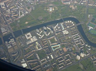
The Polmadie Bridge is a footbridge that crosses the River Clyde, Glasgow, Scotland [1] between Glasgow Green (the Flesher's Haugh area which is largely football pitches) to its north, and Oatlands (at the west side of Richmond Park) to its south.
The Polmadie Bridge is a footbridge that crosses the River Clyde, Glasgow, Scotland [1] between Glasgow Green (the Flesher's Haugh area which is largely football pitches) to its north, and Oatlands (at the west side of Richmond Park) to its south.
The first version of a bridge at the site was wooden, constructed from 1899 and completed in 1901, opening on the same day (13 June) as the original version of the nearby King's Bridge. This structure was partly destroyed by fire in 1921 and rebuilt by Sir William Arrol & Co., closing in 1939. [2] [3]
The replacement bridge, being four feet (1.2 metres) narrower than its predecessor, was constructed in 1954–1955, made from prestressed concrete. [4] It was closed by Glasgow City Council on 14 May 2015, for reasons of public safety. [5] Press Reports dated 16 July 2015 indicated the bridge was to be demolished – leaving concrete piers, and allowing restrictions on the stretch of river to be removed. Work to remove the bridge deck, leaving the concrete piers in place, began in October 2015. [6] [7] Demolition took about five months, after which access to footpaths along the riverbanks was restored. [8]
In their 2017/2018 budget announced 16 February 2017, Glasgow City Council listed plans to "Build a new cycle and footbridge between Oatlands and Glasgow Green – replacing the demolished Polmadie Bridge" as one of the key projects for the financial year. [9] Construction of the new bridge began in late 2017, with the initial £1.3 million cost [10] funded by the local authority augmented by an additional £500,000 from the sustainable transport charity Sustrans. By May 2018, the five 25-tonne beams comprising the base had been lifted into place using a large crane. [11] [12] The new bridge was completed and formally opened in August 2018. [13] [14] [15]

Braehead is a commercial development located at the former site of Braehead Power Station in Renfrew on the south bank of the River Clyde in Renfrew, Renfrewshire. It is particularly notable for its large shopping centre, arena and leisure facilities.
The Gorbals is an area in the city of Glasgow, Scotland, and former burgh, on the south bank of the River Clyde. By the late 19th century, it had become densely populated; rural migrants and immigrants were attracted by the new industries and employment opportunities of Glasgow. At its peak, during the 1930s, the wider Gorbals district had swollen in population to an estimated 90,000 residents, giving the area a very high population density of around 40 000/km2. Redevelopment after WWII has taken many turns, and the area's population is substantially smaller today. The Gorbals was also home to 16 high-rise flat blocks; only six are standing as of 2024, and two are planned for demolition around Easter time 2025.

Glasgow Green is a park in the east end of Glasgow, Scotland, on the north bank of the River Clyde. Established in the 15th century, it is the oldest park in the city. It connects to the south via the St Andrew's Suspension Bridge.

Toryglen is a district in southern Glasgow, Scotland, falling within the Langside ward under Glasgow City Council. It is approximately two miles south of the city centre, bounded to the west by Mount Florida, the north-west by Polmadie, to the north-east by the West Coast Main Line railway and the M74 motorway the south by King's Park, and immediately to the east by the town of Rutherglen.
Dalmarnock is a district in the Scottish city of Glasgow. It is situated east of the city centre, directly north of the River Clyde opposite the town of Rutherglen. It is also bounded by the Glasgow neighbourhoods of Parkhead to the north-east and Bridgeton to the north-west.

Garthamlock is a suburb in the north-east of the Scottish city of Glasgow. It is situated north of the River Clyde. Provanhall is the nearest neighbourhood to the east; Craigend is directly to the west with Hogganfield Park and Ruchazie beyond. Garthamlock is separated from Cranhill and Queenslie to the south by the M8 motorway. An area of open ground is to the north. The local landmarks are two water towers, which are illuminated at night.

Queenslie is a district in the Scottish city of Glasgow.
Sighthill is a neighbourhood in the Scottish city of Glasgow. It is situated north of the River Clyde and is part of the wider Springburn district in the north of the city. It is bordered to the north by Cowlairs, to the east by the Springburn Bypass road and the Royston neighbourhood, to the west by the Glasgow to Edinburgh via Falkirk Line and to the south by the Townhead interchange of the M8 Motorway.

Oatlands is an area in the city of Glasgow, Scotland. It is situated south of the River Clyde, falls within the Southside Central ward under Glasgow City Council, and is part of the Gorbals historic area. Its boundaries are Hutchesontown and the Southern Necropolis cemetery to the west, Polmadie to the south, Shawfield to the east, and Glasgow Green public park to the north.

Polmadie is a primarily industrial area of Glasgow in Scotland. Situated south of the River Clyde, Polmadie is close to residential neighbourhoods including Govanhill and Toryglen (south-east), with Oatlands and another large industrial zone at Shawfield to the north on the opposite side of major railway lines and the M74 motorway, Junction 1A of which serves the area.
Hutchesontown is an inner-city area in Glasgow, Scotland. Mostly residential, it is situated directly south of the River Clyde and forms part of the wider historic Gorbals district, which is covered by the Southside Central ward under Glasgow City Council.

The A728 is a route number in Glasgow, Scotland applied to two connected roads.
Bridge to Nowhere is a nickname used to refer to various unfinished structures around the M8 motorway in the centre of Glasgow, Scotland. They were built in the 1960s as part of the Glasgow Inner Ring Road project but left incomplete for several years. One "bridge", at Charing Cross, was completed in the 1990s as an office block. The Anderston Footbridge, a pedestrian bridge south of St Patrick's church, was finally completed in 2013 as part of a walking and cycling route.

Shawfield is an industrial/commercial area of the Royal Burgh of Rutherglen in South Lanarkshire, Scotland, located to the north of the town centre. It is bordered to the east by the River Clyde, to the north by the Glasgow neighbourhood of Oatlands and the adjacent Richmond Park, to the south-west by Glasgow's Polmadie and Toryglen districts, and to the south-east by Rutherglen's historic Main Street and its Burnhill neighbourhood, although it is separated from these southerly areas by the West Coast Main Line railway tracks and the M74 motorway. A road bridge connects Shawfield to the Dalmarnock, Bridgeton and Glasgow Green areas.

The Rutherglen Bridge or the Shawfield Bridge is a bridge which was built 1893–96, which crosses the River Clyde, in Scotland.

The Caledonian Railway Bridge is a bridge crossing the River Clyde at Broomielaw in Scotland. It is adjacent to Glasgow Central Station.

Auchenshuggle Bridge is a road bridge spanning the River Clyde in Glasgow, Scotland. The Auchenshuggle Bridge is the latest bridge to be built over the Clyde in the Auchenshuggle district of Glasgow, carrying the M74 motorway over the river and onto land which is part of Clydebridge Steelworks in Rutherglen, en route to the M8 junction near the heavily congested Kingston Bridge.

The Albert Bridge is a road bridge that spans the River Clyde in Glasgow, Scotland, near Glasgow Green. Opened in 1871, the bridge connects Saltmarket in the city centre with Crown Street on the city’s south side. It is category A listed structure, named in honor of Queen Victoria's consort, Prince Albert.

King's Bridge is a road bridge spanning the River Clyde in Glasgow, Scotland. The bridge links Hutchesontown to the west and Glasgow Green to the east near the city centre.

The Clydebridge Steelworks, also known as Clydebridge Works, is a steel works in South Lanarkshire, Scotland.
55°50′33″N4°14′07″W / 55.8425°N 4.2354°W
| | This article about a bridge in the United Kingdom is a stub. You can help Wikipedia by expanding it. |
| | This article about a Scottish building or structure is a stub. You can help Wikipedia by expanding it. |